
A jökulhlaup from Mýrdalsjökull into the rivers Leirá Syðri and Skálm
- The flood is subsiding, and water level and conductivity are now approaching normal values in Skálm.
- The flood reached its peak the night before last.
- IMO´s specialists continue to observe the area
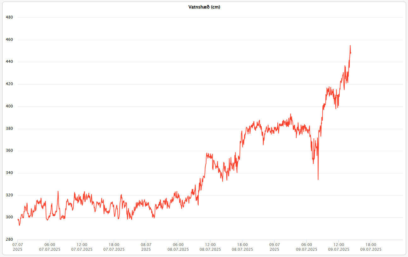
Water level (Figure 1) and conductivity (Figure 2) have decreased over the past 24 hours and are now approaching normal values at the Icelandic Meteorological Office's gauging station in Skálm by the highway. Seismic sensors on nunataks in the Mýrdalsjökull ice cap also show a clear decrease in tremor over the last 24 hours. A webcam on Rjúpnafell shows that water volume in Leirá Syðri has significantly decreased since yesterday. This data, therefore, indicates that the glacial outburst flood is coming to an end.
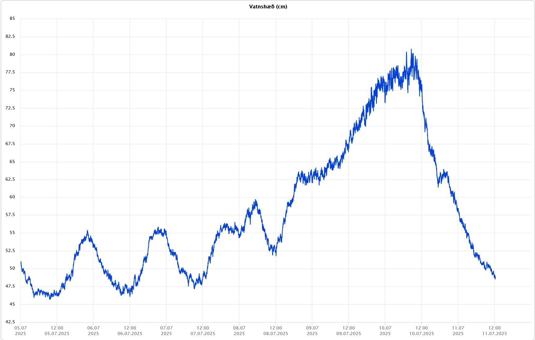
Figure 1: Development of water level in the river Skálm by the highway over the past week (5–11 July). Water level began to rise on 8 July as floodwater started entering the river.
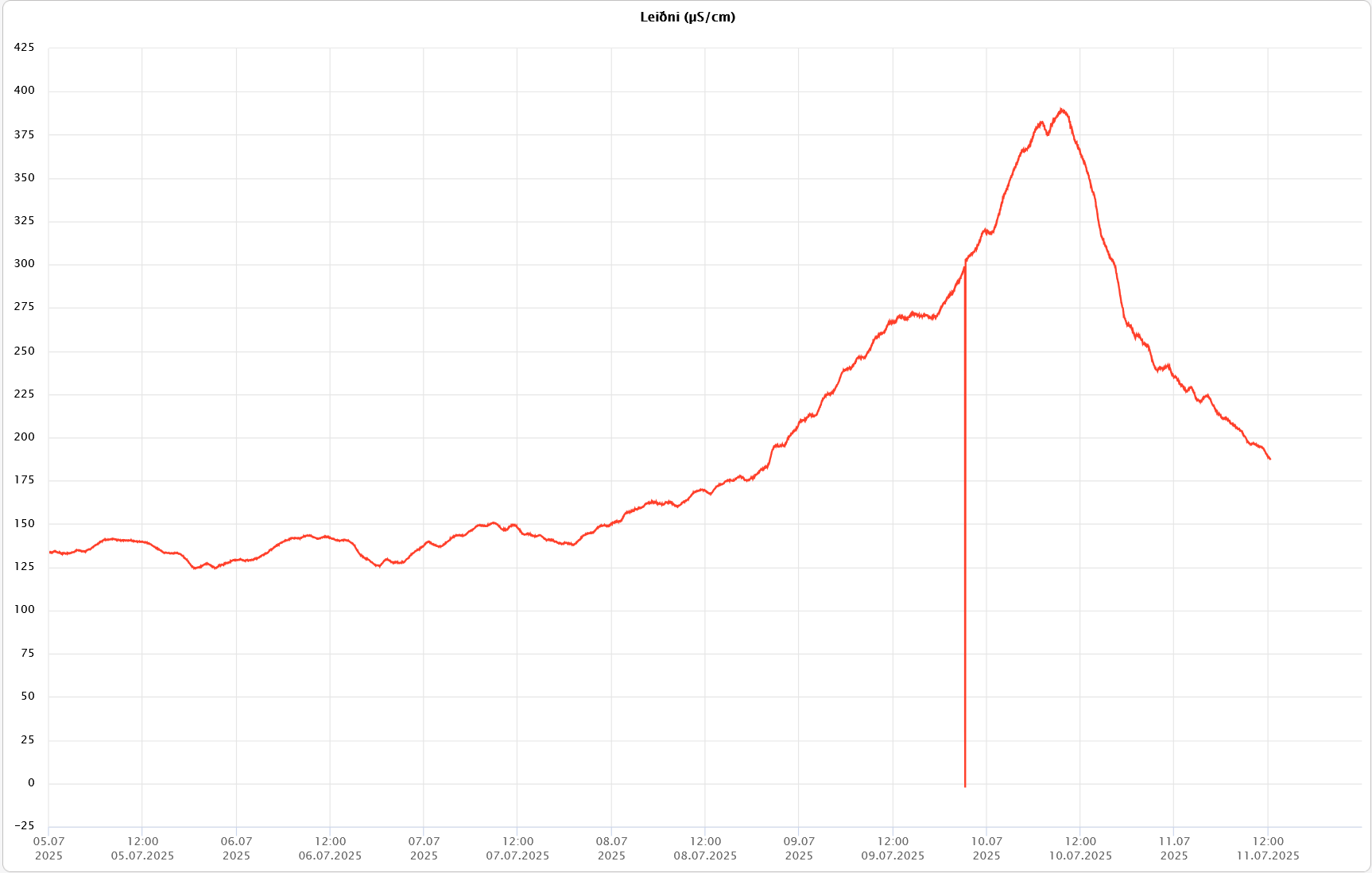
Figure 2: Development of conductivity in Skálm by the highway over the past week (5–11 July).
The gauge in Leirá Syðri shows a decrease in conductivity, while the measured water level, on the other hand, shows an increase. This rise is believed to be due to build-up of sediments in the river channel when the river's transport capacity decreased. This accumulation of sediment raises the riverbed, and consequently, the water surface is measured higher.
Sulfur smell may still be detected in the area, and travelers are advised to exercise caution near the rivers.
Updated 10 July 2025
Conductivity and water level
in Leirá Syðri and Skálm increased gradually overnight into 10 July, following
the rise seen in recent days. Towards the morning of 10 July, both water level
and conductivity began to decrease, suggesting that the peak in Leirá was
reached on the evening of 9 July (see Figure 1) and in Skálm at the bridge over
Highway 1 on the morning of 10 July. The seismic tremor at Austmannsbunga has
also subsided since the morning of 10 July and has remained low.
It is likely that the flood will continue to subside and that discharge will return to normal summer levels. It cannot be ruled out that sudden boiling in geothermal systems beneath the glacier may occur due to depressurization following the flood. Such an event could lead to melting of glacier ice and increased floodwater.
It is still too early to predict further developments at this time, and the Icelandic Meteorological Office's 24-hour monitoring remains in place to closely track measurements in the area.
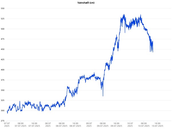
Figure 1: Development of water levels in upper Leirá Syðri from 7 July to 14:00
on 10 July.
Probable
origin of the flood
The flood likely originated
from geothermal cauldrons in Mýrdalsjökull south of Austmannsbunga (cauldrons
13 and 14 in the Kötlukettle numbering system), the same cauldrons that
produced a considerable flood in July last summer. Ice radar
measurements conducted by Eyjólfur Magnússon from the Institute of Earth
Sciences, University of Iceland, in May this year suggest that there may have
been substantial water accumulation beneath these cauldrons at the glacier bed,
and that this reservoir could be the source of the current flood. However, no confirmation has yet
been obtained of a lowering of the glacier surface in the cauldrons, and
therefore this cannot be stated with certainty. Remote sensing data in the
coming days may help confirm this. Reports by pilots flying over the area could
also be valuable.
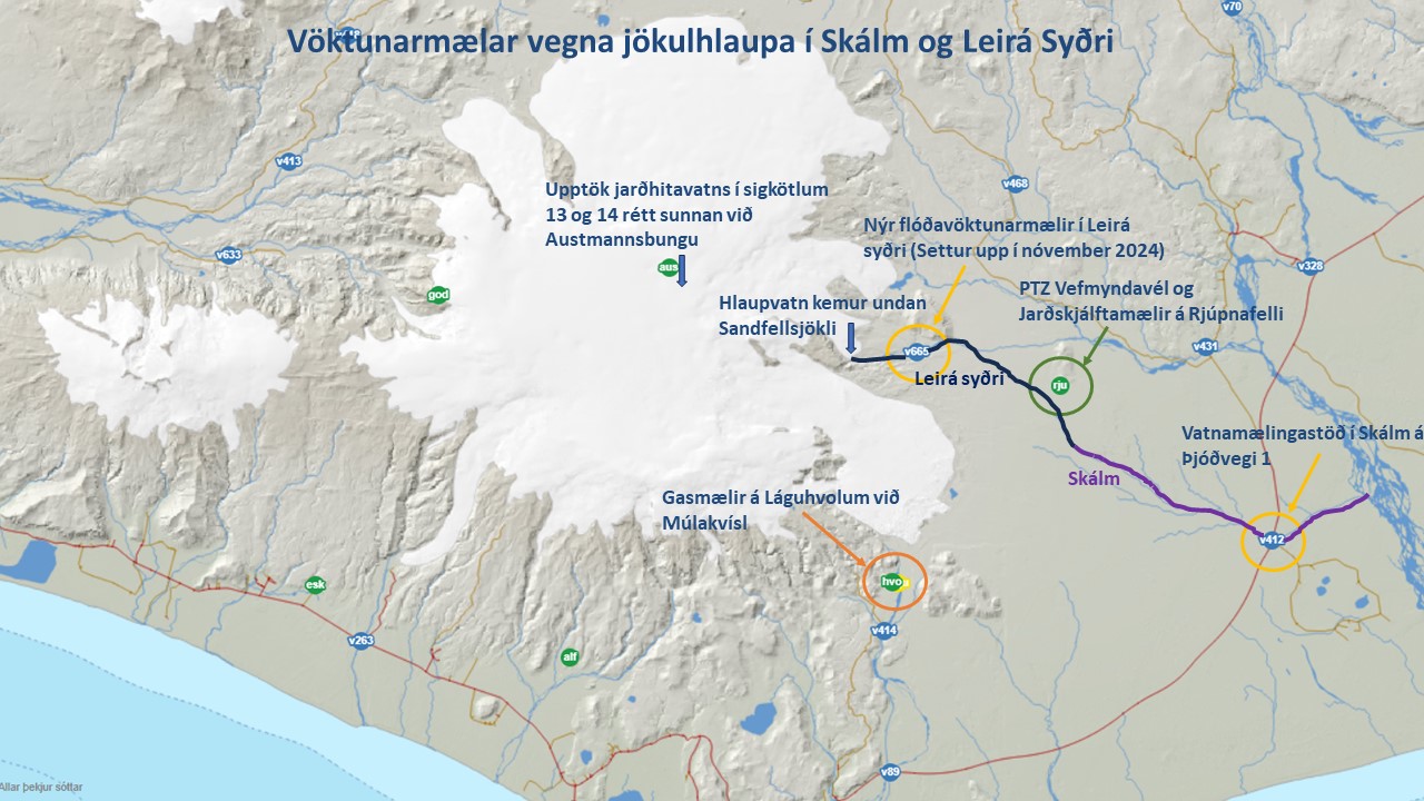
Figure 2: Map showing the location of monitoring instruments around
Mýrdalsjökull and the course of Leirá Syðri in Skálm.
Reports of sulfur odors and advice to travelers
Reports of a sulfur smell near
Skálm have been received by the Icelandic Meteorological Office. Travelers are
advised to exercise caution near the rivers, as gas pollution could be present
in the area. It should also be noted that care should always be taken near
river channels.
Since 8 July 2025, nearly 100 earthquakes have been recorded in Mýrdalsjökull, the largest occurring at 7:00 on 10 July, with a magnitude of 2.7. Larger earthquakes cannot be ruled out, so caution is advised in and around the glacier.
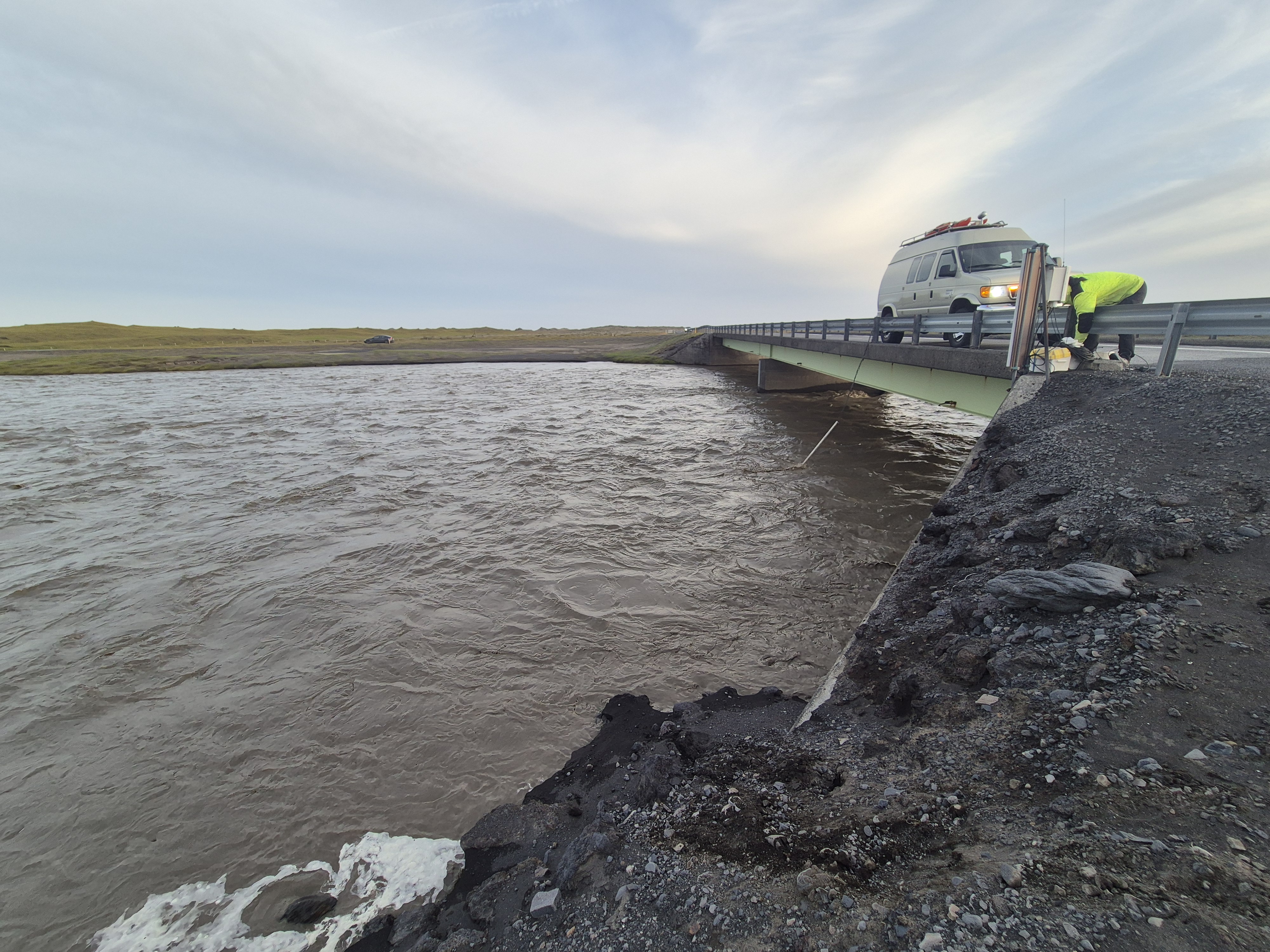
Figure 3: Specialists from the Icelandic Meteorological Office taking
measurements at Skálm on 9 July. Photo: Njáll Fannar Reynisson.
Additional
observations in Fremri-Emstruá
In addition to the flood in
Leirá and Skálm, reports of floodwater in Fremri-Emstruá have been received.
This is most likely an unrelated event, as similar floods occur in this river on
an annual basis. These floods usually happen between late June and early
August. Such floods do not typically cause damage or pose a hazard, except for
potential gas emissions near the riverbed by the glacier. Travelers are
therefore also advised to exercise caution due to possible gas emissions near
Fremri-Emstruá and at the edge of Entujökull.
Updated 9 July 2025
In recent days, conductivity and water level have increased in Leirá Syðri according to measurements from a new monitoring instrument in front of Sandfellsjökull. Elevated conductivity and water level are also seen in measurements at the bridge on Highway 1 over Skálm, as Leirá Syðri flows into Skálm upstream of the road.
At this stage, this is considered a minor flood event, but at this point, water level and conductivity are still gradually increasing.
Reports of a sulfur smell have been received by the Icelandic Meteorological Office. We would therefore like to ask people to exercise caution near the river's source, as gas pollution could be present in the area. It should also be noted that care should always be taken near river channels.
The Icelandic Meteorological Office's 24-hour monitoring continues to closely track the development of measurements in the area. Further information will be provided as the event progresses.
Development of water level in upper Leirá Syðri from 7 July to 15:00 today, 9 July.
Variable size of glacial floods from Mýrdalsjökull into Leirá
Floods of this type, originating in geothermal areas beneath the glacier, are known to occur in several rivers around Mýrdalsjökull, such as Múlakvísl and Fremri-Emstruá.
Over the years, floods of varying size have occurred in Leirá. Between 1995 and 2000, annual floods occurred in the river, in addition to a small flood in 2012. These floods caused no damage other than sediment deposition that built up the Leirá alluvial fan south of Sandfell, which in turn caused the southern channel of Leirá to shift into new areas and eventually over into Skálm.
At the end of July last summer, a minor flood also occurred in Leirá Syðri and Skálm. Following that event, an unexpected substantial flood took place, overflowing Highway 1 and breaching it in places. The flood originated in two cauldrons in Mýrdalsjökull south of Austmannsbunga. These cauldrons are formed by ice melting caused by geothermal heat at the glacier bed.
Since the major flood at the end of July 2024, four smaller floods have occurred in the river. None of these caused any damage. The last such flood occurred this past December.
“The causes of last year's major flood are not fully understood,” says Bergur Einarsson, Head of Hydrology at the Icelandic Meteorological Office.
“If boiling in geothermal systems beneath the glacier, triggered by depressurization following a minor glacial flood, caused the major flood last year, then an event like the one currently underway could lead to a larger flood. We also need to be cautious because the ice radar measurements by Eyjólfur Magnússon at the Institute of Earth Sciences from this past May indicate that there may already be substantial water accumulation at the glacier bed,” says Bergur.


