
Askja volcano continues to inflate at a steady rate and there is currently no indication of an escalation in activity
Inflation has been steady since the end of September 2021
Deformation measurements (GPS and InSAR analysis) indicate that inflation at Askja is continuing at a constant rate since the end of September 2021. Total vertical displacements at GPS station OLAC (on the western edge of Öskjuvatn) have now reached 60 cm since the start of unrest (August 2021). Deformation modeling suggests the top depth of the inflation source is around 2.5-2.9 km below the caldera floor. The source of the deformation has not changed since September 2021.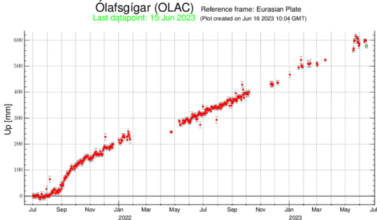
The graph shows uplift in Ólafsgígar, located just west of the lake, from August 2021 until 15 June 2023. Total uplift is now around 60 cm.
Since the end of 2021 until June 2023 seismic activity has been rather stable in Askja and around 20-60 earthquakes (>M0.5) have been detected there each month. The largest earthquakes each month have ranged from M2 up to M3.1. When the deformation was fastest in September 2021 up to 150 earthquakes were detected there that month.
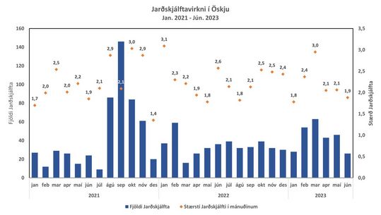
This graph shows seismic activity in Askja from January 2021 until mid-June 2023. Blue bars show the number of earthquakes (> M 0.5) per month and orange dots mark the largest earthquake each month.
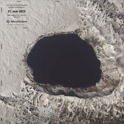
The IMO (Icelandic Meteorological Office) monitors Askja volcano with a network of seismometers, GPS instruments and data from satellites. Satellite images show that the caldera lake in Askja has been ice free since the end of May like other waters in the area.
Further information on Askja volcano is available in the Catalogue of Icelandic Volcanoes.


