
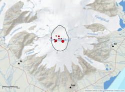
Earthquake 3.6 in the caldera of Öræfajökull
On the 9th February 2018 at 05:07, an earthquake of magnitude 3.6 occurred within the caldera of Öræfajökull volcano. Around 10 aftershocks have been recorded. The earthquake was felt by few people in the area, however most people slept through it.
This earthquake is the largest recorded in Öræfajökull (instrumentation in the area started in 1976). The earthquake occurred inside the caldera just southeast of the ice-cauldron that formed in November last year. The depth seems to be confined in the first few kms of the crust. Öræfajökull has been showing signs of unrest for over a year. Two other earthquakes larger than M3 have been recorded since last fall (M3.5 on the 3rd October 2017 and M3.1 on the 18th January 2018).
No significant changes have been observed for the past weeks with other monitoring data, including deformation, hydrological and geochemical data available to the Icelandic Meteorological Office. An overflight, to measure glacial surface will be done as soon as the weather condition allow. This is important as it can reflect changes of the underlying geothermal system. In addition, satellite images will be acquired in the next days to identify possible changes of the ice-surface. No significant changes have been seen in the satellite images this year (last image required end of January).
The Aviation Color Code for Öræfajökull is kept on a yellow level. IMO keeps monitoring the volcano 24/7 and any detected relevant changes will be communicated promptly through the usual channels.
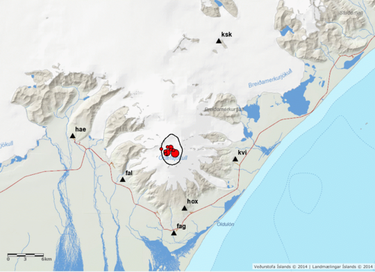
Öræfajökull on the map. The red dots show recent earthquakes; the black triangles show location of IMO's seismographs.


