
Earthquake swarm ongoing offshore Reykjanestá
- Up to 600 earthquakes detected so far
- Many seismic swarms occurred in the area since 2021
- The activity may continue with intermittent behavior
- No clear evidence of deformation in the area
At around 14:30 yesterday (12 March 2025), a rather intense earthquake swarm began offshore Reykjanestá. The swarm was most intense at the beginning when about 50 – 60 earthquakes were recorded in the first few hours. As the day progressed, the activity decreased but then increased again shortly before midnight when an earthquake of magnitude 3.5 occurred. When the activity increased again in the evening, it shifted slightly westward as the image shows (blue circles indicate the location of earthquakes that occurred at the beginning of the swarm yesterday, while yellow and red ones show earthquakes from late last evening and night).
So far, about 600 earthquakes have been detected within in the area, including six earthquakes over magnitude M3. Reports have been received that some earthquakes were felt in populated areas, including Grindavík town, which is about 12 km east of the activity. The behavior of the swarm so far shows that the activity can decrease and then suddenly increase again. Since 2023, five earthquake swarms have occurred in the same area where the activity is now. In addition, there have been considerable swarms there in 2021 and 2022, to name a few examples. The earthquakes are possibly trigger earthquakes due to changes in the stress field on the Reykjanes Peninsula in conjunction with seismic activities and magmatic intrusions in the recent years. Deformation data over the past few days do not show clear evidence that the current seismic activity is due to magma movement at depth. However, scientists at the Icelandic Meteorological Office are closely monitoring all measurements around Reykjanesstá to identify the most likely cause of the earthquake swarm.
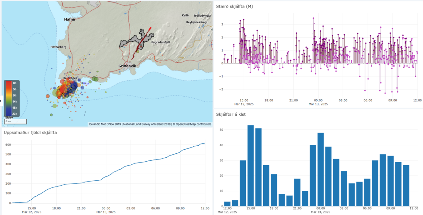
Data from Skjálfta-Lísa, the Icelandic Met Office's earthquake monitoring system. The map displays the locations of earthquakes since noon on March 12, showing two distinct clusters. The graph below the map represents the cumulative number of earthquakes since the swarm began. The top right graph illustrates earthquake magnitudes, with reviewed earthquakes in darker colors and automatic magnitudes in lighter shades. The bar chart on the right shows the number of earthquakes per hour since noon yesterday.


