Flood in Skaftá
Updated on 29 August, at 17:00
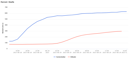
Hydrological measurements in Skaftá at Sveinstindur show that the increase in discharge has slowed down.The discharge is estimated 620 m3/s at 15:00 compared to 600 m3/s at 9:00 this morning.
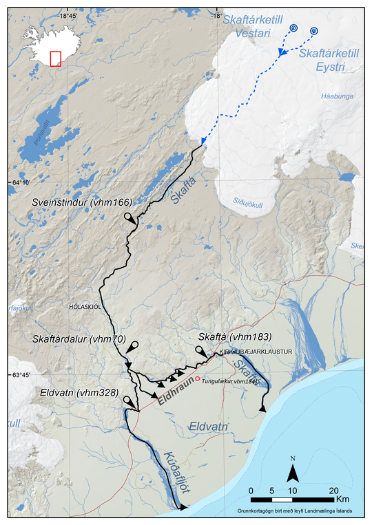
As the image below shows, the discharge gradually increases downstream in the river. It usually takes the flood water about 8-10 hours to travel between the gauging station at Sveinstindur and the gauging station at Eldvatn near Highway 1.
The graph shows the comparison between the discharge measured at Sveinstindur (blue line) and Eldvatn (red line)
Glacial floods in Skaftá have occurred at fairly regular intervals in the past 50 years. During the period from 1955 to 2018, 28 floods originated from the eastern cauldron, while floods from the western cauldron are more frequent. A total of 30 floods came from it between 1972 and 2018. In the past 50 years, it is almost as if there is an average of one flood per year from the cauldrons.
There is a correlation between peak discharge and the time passed since the last flood. Following the longest interval between floods from the eastern cauldron (2010-2015), the largest known flood in Skaftá occurred in October 2015. The peak discharge during that flood reached around 3.000 m3/s. When comparing current discharge with past floods and considering the most recent flood in Skaftá in 2021, it is rather likely that this is a typical flood event. Such floods do not pose a threat to infrastructure, and the floodwater does not overflow Highway 1.
Looking at historical data, it is most likely that the discharge will not increase significantly beyond this, and the flood will decrease within a few days. However, there are instances where another peak in the discharge follows the first one. In those cases, the other cauldron floods following the first one, resulting in a double Skaftá glacial flood. This occurred last in September 2021, with the western cauldron flooding first, and then five days later, water from the eastern cauldron flooded as well. The peak discharge during that flood was estimated around 1,500 m3/s.
The IMO continues to closely monitor the situation. People in the area are warned about the possibility of high concentration of geothermal gas near the source of river Skaftá. Sulfur dioxide is carried by the floodwater when it emerges from beneath the glacier. Air quality at Kirkjubæjarklaustur can be monitored on loftgaedi.is.
Previously issued:Yesterday evening the discharge and conductivity in Skaftá at Sveinstindur started to increase. The IMO has also received reports of sulfuric smell from rangers in the area. It can therefore be concluded that a glacier outburst flood has begun. The last flood occurred in September 2021.
The Skaftár cauldrons are two, the eastern and the western, and are in the western part of Vatnajökull Ice-cap. A flood from the Eastern cauldron are usually larger than from the Western cauldron. It is not confirmed which cauldron is flooding, but scientists are looking at satellite data to confirm which one is flooding or if they are both. That happened in 2021 and could repeat itself.
Discharge at Sveinstindur was 600 m3/s around 9 am and is increasing. It can be expected to reach maximum discharge at Þjóðvegur 1 approximately 10 hours after the maximum discharge at Sveinstindur is reached. The size of the flood depends on which of the cauldron is flooding.
The police and civil protection have declared a state of uncertainty regarding the flood in Skaftá.
Discharge at Sveinstindur was about 600 m3/s at 9 am.
Possible hazards
It is important that locals and people traveling in the area are aware of possible hazards and conditions there.
- In the next few days, it is possible that Skaftá will overflow roads that lie close to the river's pathway.
- High concentration of H2S is expected near the margin of Skaftárjökul and people are advised to stay at a safe distance from the river and the margins of nearby glaciers as it can have effects on the lungs and eyes.
- Travelers are advised to stay away from Skaftá above Skaftárdal and the edge of Skaftárjökull, Tungnárjökull and Síðujökull while the flood is ongoing.
- Crevasses will form rapidly around the cauldron, therefore people travelling on Vatnajökull ice-cap should stay away from the cauldrons and margins of glaciers where floodwater is emerging.
A total of 59 floods are known to have occurred in Skaftá
The Skaftá cauldrons, eastern and western, are located in the western part of Vatnajökull Ice-cap. They form because of geothermal activity that melts the glacier from below and water accumulates beneath them. When the hydrostatic pressure is high enough for the water to lift the ice above and flow from below the cauldrons it causes a flood. Floods from the eastern-cauldron are usually larger than the floods from the western-cauldron. Floods from the Skaftá-cauldrons as we know them today were first observed 1955 and since then 59 floods have occurred. On average floods from each cauldron occur every two years.
Here you can read more
about hazard assesment due to glacier outburst floods in Skaftá. (Icelandic)


