
Conclusion of Grímsvötn Glacial Outburst Flood
Ice cauldron formed south of Grímsfjall
Updated 23 January at 9:00 UTC
Since the glacial flood reached its peak in the river Gígjukvísl approximately a week ago, the water level has been decreasing and is now comparable to what it was before the flood. The seismic tremor measured on the seismometer at Grímsfjall has also declined, with seismic noise now back to normal levels. Since last week Monday, 21 earthquakes have been recorded in Grímsvötn, including two earthquakes exceeding magnitude two.
During the glacial flood from Grímsvötn in 2021, an ice cauldron (GV-33), which is crevassed depression on the glacier surface, formed south of Grímsfjall. The cauldron is located near the flood path, where water drains beneath the glacier. Staff of the Icelandic Meteorological Office, who were on a trip to conduct measurements at Vatnajökull last week, identified a depression similar to the 2021 ice cauldron in the same location. Upon closer examination of satellite images from yesterday, January 21, two cauldrons south of Grímsfjall can be observed. One of them is confirmed to be the cauldron that formed in the 2021 flood, but the other may either be a new cauldron that formed during the recent flood or an older cauldron that has re-emerged. The ice cauldrons are near the route east of Grímsfjall, and it is advisable to avoid the cauldrons when traveling along those routes.
The coordinates for the cauldrons' locations are as follows:
- Cauldron GV-33: 64°23.611', -17°13.017' (decimal degrees, WGS-84)
- New cauldron: 64°23.766', -17°12.729' (decimal degrees, WGS-84)
When the recent glacial flood began, the aviation color code for Grímsvötn volcano was elevated to yellow, signifying the heightened potential for an eruption following pressure changes in the system after water drained from the subglacial lake. Now that the glacial flood is over and that there have been no significant changes in short-term seismic activity, the aviation color code will return to green.
Long-term monitoring of seismic activity at Grímsvötn reveals that, in the last five months, the number of earthquakes has been higher than the typical background seismicity. If an eruption were to occur in Grímsvötn, an increase in seismic activity may be expected before the eruption begins, but warning times may be short. Scientists from the Icelandic Meteorological Office and the Institute of Earth Sciences will continue to closely monitor Grímsvötn and provide information if activity increases further.
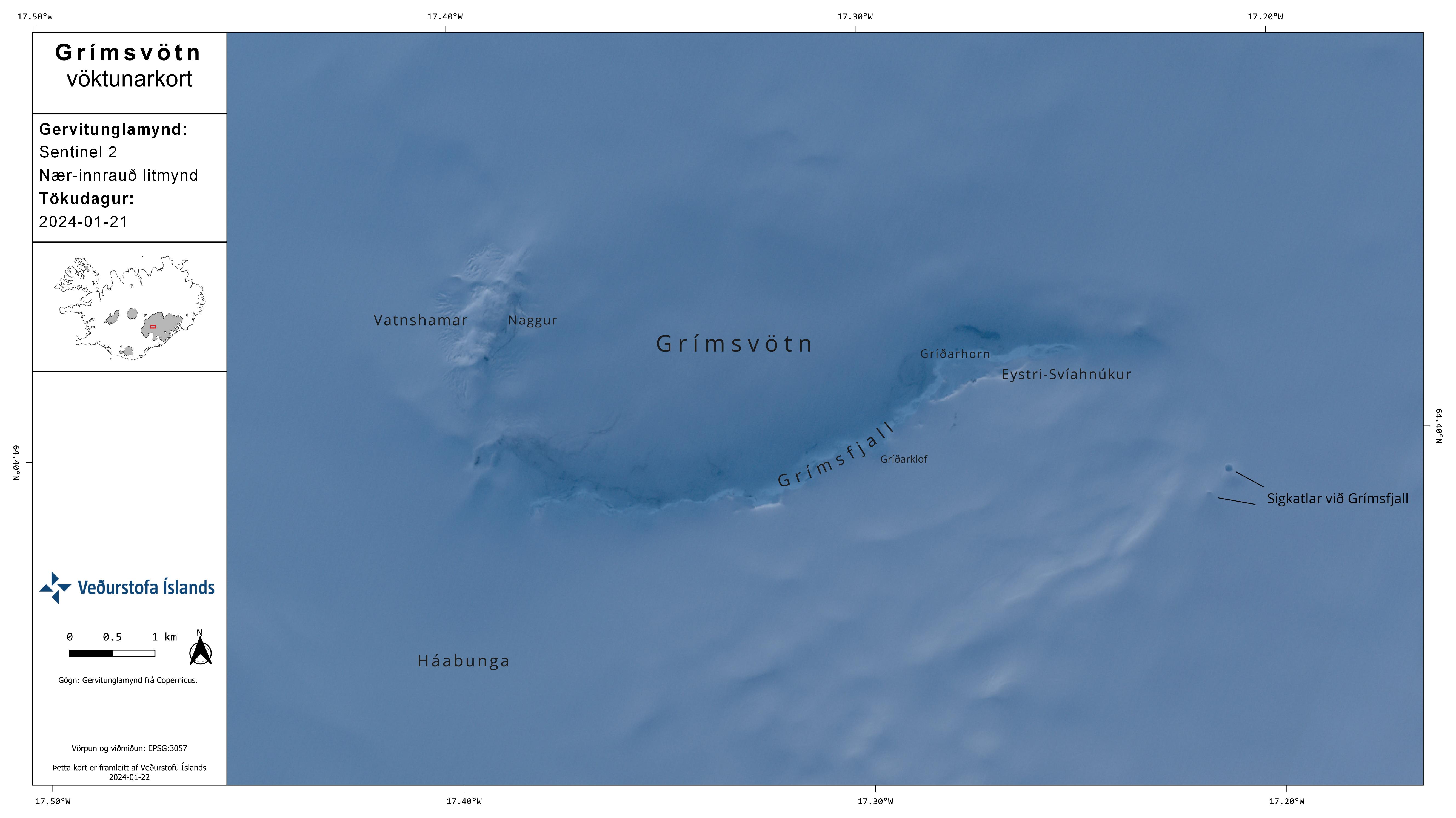
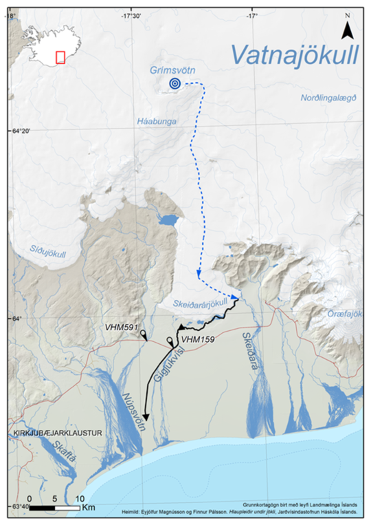
The map shows Grímsvötn and the location of the two ice cauldrons south of Grímsfjall.
Updated 15 January at 18:00 UTC
The water level in Gígjukvísl has remained relatively stable since last night, indicating that the river has reached its peak flow. It is expected that the flow will gradually decrease in the coming days until the flood subsides. Since midnight on January 15, the seismometer at Grímsfjall has recorded increased tremor, which is likely related to heightened geothermal activity in the Grímsvötn system and is a phenomenon commonly observed towards the end of glacial outburst floods. Similar unrest has been documented during previous jökulhlaups from Grímsvötn. While seismic activity in Grímsvötn has been minimal today and over the weekend, the earthquakes that have been detected in the region all measure below magnitude 2.0. If an eruption were to occur in Grímsvötn, a significant increase in seismic activity is expected before the eruption begins.
Updated 15 January 16:00 UTC
The glacial flood out of Grímsvötn is believed to have reached its peak Saturday evening, based on a change in the seismic tremor signals. Discharge and conductivity in Gígjukvísl increased until Sunday night, at which point the discharge stabilized, indicating that the river has reached its peak flow. It is expected that the flow will gradually decrease in the coming days until the flood subsides. Since midnight on January 15, the seismometer at Grímsfjall has recorded increased tremor, which is likely related to heightened geothermal activity in the Grímsvötn system and is a phenomenon commonly observed towards the end of glacial outburst floods. Similar unrest has been documented during previous jökulhlaups from Grímsvötn. While earthquake activity in Grímsvötn has been minimal today and over the weekend, the earthquakes that have been detected in the region all measure below magnitude 2.0. If an eruption were to occur in Grímsvötn, a significant increase in seismic activity is expected before the eruption begins.
The Icelandic Meteorological Office, along with scientists from the University of Iceland's Institute of Earth Sciences, will continue to closely monitor Grímsvötn.
Updated 12. January at 10:30 UTC
In the last two days, the water level
of Gígjukvísl has been steadily and significantly increasing. This is evident
in the river, which is spreading out and widening in its channel, and by the
water level gauge at the bridge crossing of the national Highway 1, which
indicates that the water surface beneath it has risen by about 70 cm in two
days. The conductivity in the river has also slightly increased, indicating
signs of an increased amount of glacial outburst flood water in the river. No
earthquake activity has been detected in Grímsvötn or along the subglacial
flood path beneath Skeiðarárjökull since yesterday. Seismic tremor from the
flood exhibits a consistent increase in strength at the Grímsfjall seismometer,
suggesting that the water outflow is still increasing from Grímsvötn. It is
still expected that the glacial outburst flood in Grímsvötn will reach its peak
flow around or shortly after the weekend, and in Gígjukvísl 1-2 days later.
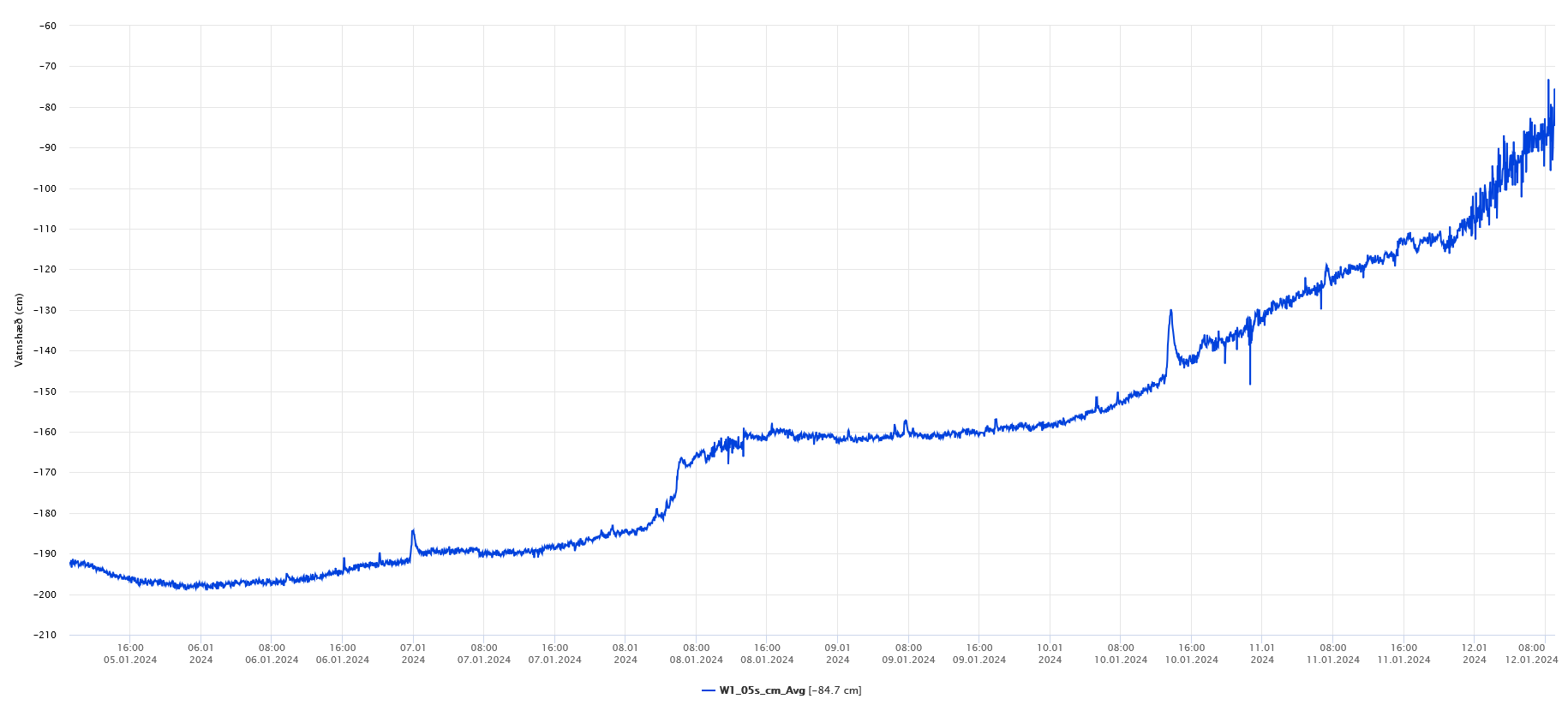
Image 1: Data from the water level gauge at the bridge over Gígjukvísl, displaying data for the last 7 days.
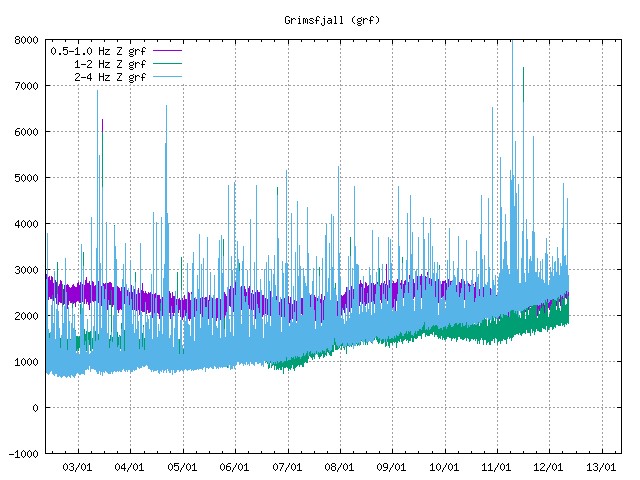
Image 2: Average seismic amplitude measurements at Grímsfjall over the past 10 days. The blue curve illustrates that tremor from the glacial outburst flood has been steadily increasing in the past few days, exhibiting strong frequencies between 2 and 4 Hz. The ground vibration (tremor) contains a range of frequencies and it has proven to be useful to analyze it in different frequency intervals, so the signal is band-pass filtered for three different frequency bands (ranges). They are shown in different colors, 0.5 - 1.0 Hz (violet), 1.0 - 2.0 Hz (green), and 2.0 - 4.0 Hz (blue). It is often helpful to have these three different ranges to analyze of which origin the detected signal is.
The Icelandic Meteorological Office, along with scientists from the Institute of Earth Sciences at the University of Iceland, will continue to monitor Grímsvötn. The next news update can be expected on Monday, January 15, unless changes in activity arise over the weekend. The Meteorological Office's 24-hour monitoring team will keep a close eye on the area and issue notifications earlier if necessary.
Further information about Grímsvötn can be found in the Catalogue of Icelandic Volcanoes.
Released 11. January at 13:30 UTC
This morning at 06:53, a magnitude 4.3 earthquake occurred in Grímsvötn. This is the largest earthquake that has occurred in Grímsvötn since the beginning of measurements in 1991. A gradual increase in tremor has been detected at Grímsfjall since January 7, and the water level in Gígjukvísl has been increasing since last night. Therefore, a glacial lake outburst flood (jökulhlaup) has started from Grímsvötn. It is likely that the earthquake this morning is due to pressure relief following the onset of the glacial flood. There is no communication with the GPS device operated by the Institute of Earth Sciences at the University of Iceland on the ice shelf in Grímsvötn, which complicates efforts to estimate the outflow rate from the subglacial lake and the ensuing developments.
The last flood from Grímsvötn occurred in October 2022, and before that in November and December 2021. The current water volume in Grímsvötn is estimated to be around 0.29 km3, which is a 50% greater volume than at the start of the 2022 flood and just under one-third of the volume of the 2021 flood. It is therefore expected that this glacial flood will be relatively small, with no impact on infrastructure such as roads and bridges.
If this event resembles the last two floods, it can be expected that the peak discharge from Grímsvötn will occur during or shortly after the upcoming weekend. Peak flow would then occur beneath the ringroad (Route 1) bridge over Gígjukvísl approximately 1-2 days later. The maximum discharge from Grímsvötn will likely not exceed 1000 m3/s, and it can be anticipated that the peak discharge in Gígjukvísl will be similar.
There are examples of volcanic eruptions occurring in Grímsvötn in the aftermath of jökulhlaups (glacial floods). In those cases, it is believed that the eruptions are triggered by the sudden pressure drop due to decreasing water level. The last such sequence occurred in 2004, and before that in 1934 and 1922. However, it is more common that floods from Grímsvötn occur without triggering volcanic eruptions. Since 2004, twelve glacial floods have taken place without causing volcanic activity. The most recent eruption from Grímsvötn occurred in 2011, but this was not preceded by a jökulhlaup.
In response to the onset of the glacial flood and increased seismic activity, the aviation color code for Grímsvötn volcano will be changed to yellow, in accordance with the volcano showing signs of activity beyond background levels.
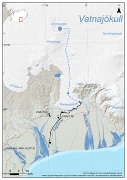
Map showing the floods pathway from Grímsvötn down to Skeiðarársandur
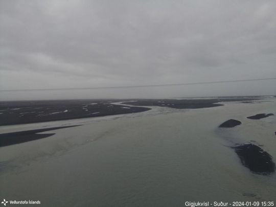
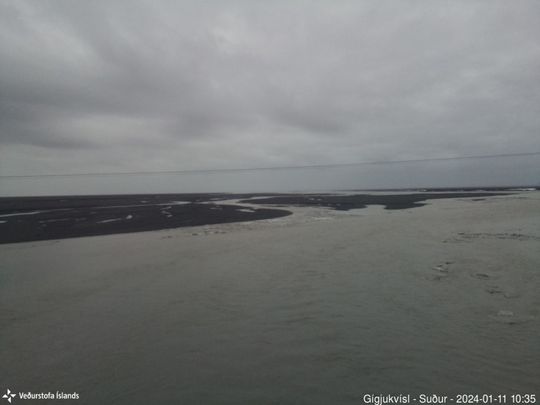
These photos are from a webcam on the bridge over Gígjukvísl on Road 1 and they show the difference in water lever between January 9th and 11th
The Icelandic Meteorological Office, along with scientists from the University of Iceland's Institute of Earth Sciences, will continue to monitor Grímsvötn and will provide information on the development of the event as it unfolds.


