Glacial outburst flood from Grímsvötn likely in progress
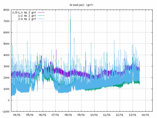
Gradual increase in seismic tremor associated with flooding recorded in Grímsfjall in recent days
- Peak discharge is likely to be reached at the end of this week if this event unfolds like previous glacial outburst floods from Grímsvötn.
- The flood is not expected to affect infrastructure, such as roads and bridges.
- Glacial outburst floods from Grímsvötn have occurred almost annually since November 2021, with the last prior flood being in 2018.
- There have been instances where volcanic eruptions followed the pressure release from Grímsvötn after water was discharged. However, glacial outburst floods occur more often without triggering eruptions.
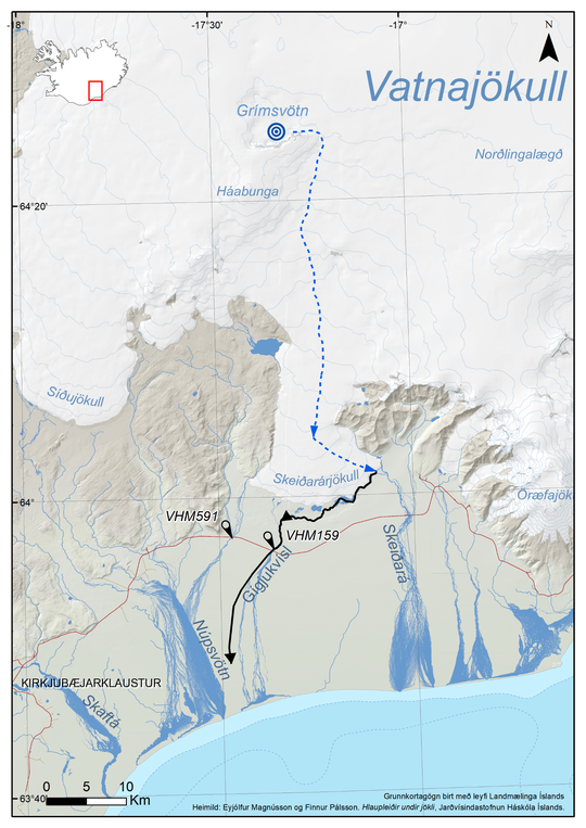
In recent days, a gradual increase in seismic tremor has been recorded on the Grímsfjall seismometer, suggesting that a glacial outburst flood has begun from Grímsvötn. These floods emerge from the base of Skeiðarárjökull glacier, flowing into the Gígjukvísl river. Typically, these glacial outburst floods increase gradually, and it can take a few days for the first signs of floodwater to be detected at the hydrological station in Gígjukvísl river and an additional few days before peak discharge is reached. With precipitation in southeast Iceland in the past days, and more expected in the coming days, the identification of the initial signs of the flood In Gígjukvísl could prove to be challenging.
Tremor graph from Grímsfjall seismometer. The graph displays data across three different frequency bands, each represented by a separate color. The graph helps scientists to evaluate the origin of the different tremors. The blue line (2-4 Hz) shows steadily increasing flood tremor over recent days.
The last glacial outburst flood from Grímsvötn occurred nearly a year ago, and floods have been recurring approximately annually since November 2021. Prior to this, the intervals between floods were longer, with the last flood before 2021 occurring in 2018. According to data from the Institute of Earth Sciences (University of Iceland), the water volume in Grímsvötn is currently estimated at 0.25 km³, comparable to or slightly less than the volume before the previous flood. This volume is about one-third of the amount stored before the larger flood in late 2021.
Currently there is no communication with the GPS device operated by the Institute of Earth Sciences at the University of Iceland on the ice shelf in Grímsvötn, which complicates efforts to estimate the outflow rate from the subglacial lake and the ensuing developments. However, seismic tremor measurements at Grímsfjall provide indications of the flood's progress. If this event unfolds like previous ones, peak discharge from Grímsvötn is expected by the end of the week. Peak flow at Gígjukvísl by road number 1 will likely follow 1-2 days later. Based on the current water volume in Grímsvötn, peak discharge is not expected to exceed 1,000 m³/s. This peak flow is unlikely to affect infrastructure, including roads and bridges.

Map showing the estimated flood path from Grímsvötn into Gígjukvísl river across Skeiðarársandur. The IMO hydrological station in Gígjukvísl (V159) is marked on the map.
In recent floods, new cauldrons have formed on the glacier's surface above the flood path southeast of Grímsfjall. Thus, travelers on Vatnajökull should show extreme caution if near Grímsfjall. There is also a hazard of gas pollution at the glacier edge at Skeiðarárjökull, where floodwater emerges.
There are instances of volcanic eruptions in Grímsvötn following glacial outburst floods. Sudden pressure drops due to decreased water levels are believed to possibly trigger eruptions. This sequence last occurred in 2004 and previously in 1934 and 1922. However, floods without eruptions are much more frequent, with 13 floods since 2004 not triggering eruptions. The last eruption in Grímsvötn was in 2011, unrelated to a previous glacial outburst flood.
The seismic activity in Grímsvötn in recent months has not exceeded background levels. However, during the flood, earthquake activity is likely to increase. The IMO's 24-hour monitoring team, along with experts from the Institute of Earth Sciences, will closely monitor Grímsvötn's activity in the coming days. This news report will be updated later in the week, with daily updates from the natural hazard specialists on the IMO´s webpage.
Due to uncertainties about the event's progression and the connection between floods and eruptions in Grímsvötn, the IMO will reassess the aviation color code for Grímsvötn as the flood approaches its peak, or if conditions change.
Grímsvötn and its glacial floods
Grímsvötn is one of Iceland's most active volcanic systems, located near the center of Vatnajökull glacier. In the volcano's caldera is a subglacial lake formed by geothermal heat and surface meltwater. When the water volume and pressure reach a critical level, the water breaks through the glacier's base, flowing eastward. The floodwater emerges at the edge of Skeiðarárjökull, flowing into Gígjukvísl river.
Approximately 20 eruptions have occurred in Grímsvötn and its vicinity over the past 200 years. The most recent eruption, in 2011, was large and intense (Volcanic Explosivity Index=4). Other recent eruptions have been smaller, lasting only a few days. More information about Grímsvötn can be found in Catalogue of Icelandic Volcanoes


