Grímsey earthquake swarm
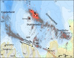
Earthquake swarms are happening frequently in the vicinity of Grímsey. An earthquake swarm about 10-12 km North-East of Grímsey started on February 14. As of noon on February 16, over 1000 earthquakes have been detected, with 10 over magnitude 3. As of this time, the intensity of the swarm is diminishing, however the activity could reinvigorate. The largest, with an estimated magnitude of 4.1, occurred at 19:27 on February 15. Some of the earthquakes have been felt in Grímsey. This is the most intense swarm in the area since 2013, when a magnitude 5.5 triggered a significant aftershock sequence.
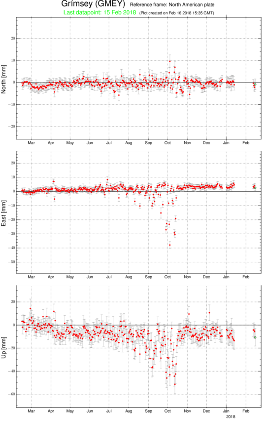
The energy release associated with this swarm, until noon on February 16, is significantly less than the 2013 sequence, see older news, although this swarm is more steady. Continuous GPS measurements in Grímsey show no detectable deformation associated with the swarm, suggesting that the swarm is tectonic in nature although geothermal activity in the area may act as a trigger. There is no sign of magmatic activity.
This area is an active seismic zone and earthquake swarms like this one can potentially trigger much larger events. Information about preparedness for large earthquakes can be found in Icelandic at the Department of Civil Protection and Emergency Management of the National Commissioner of the Icelandic Police .
Figure above:
Earthquakes since the beginning of 2018 are seen as red dots. Earthquakes with a magnitude between 3-4 are indicated as black stars and earthquakes with a magnitude over 4 as white stars. Grey dots show earthquake activity in 1994-2017. Black triangles show the location of seismic stations and the black arrows show the movement across the Húsavík Flatey fault.
Figure below:Displacements of the GPS station in Grímsey in mm for North, East and Up directions are shown as a time series for the past year. No detectable change is observed during the current seismic swarm.


