
Re-evaluation needed of the size of the hazard area
Updated 03.05. at 12:15
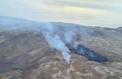
The eruption in Fagradalsfjall continues through one main crater. The active crater is the fifth fissure opening that opened in the area on the 13th of April. Since the 27th of April, the volcanic activity was characterized by continuous lava fountains, while the activity changed at around midnight on the 2nd of May, and has since been showing pulsating behaviour. These pulses have intermittent active periods of 8-12 minutes, with 1-2 minutes of rest periods in between. The active pulses start with a strong fountain activity, with fountains reaching up to 100-150 m above ground level, and some even higher. These pulses are very apparent in the seismic tremor from seismic stations in a wide area around the eruption site.
On Sunday morning, just after 6 am, the wind direction changed to slow easterly, and a few hours later smoke was detected in the southwest slopes of Geldingadalir. Possibly, hot pyroxene from the eruptive crater has been carried by the wind to the southwest of the lava field for about 300 meters distance and started a brush fire which can be seen on one of the two RÚV webcams.
It is not clear what is causing these changes in volcanic activity, but changes in magma flow, the chemical composition of magma/gas, or possibly changes in the volcanic conduit cannot be ruled out.
Considering these changes in activity, the size of the hazard area at the eruption site is being re-evaluated.
Updated 21.04. at 16:00
With the Fagradalsfjall eruption continuing for over a month, it is natural to ask how long the eruption will last. New fissure openings have formed several times since the eruption began and, in recent days, volcanic activity at the northernmost crater has ceased.
„It is not clear what this means for the progress of the eruption.“ says Sara Barsotti, volcanic hazards coordinator at IMO. „Since the eruption began about thirty days ago, it has been changing constantly. Presently, there is no magma flowing from the first crater that opened outside Geldingadalir. This, for example, reflects the constant changes, although it is uncertain if the crater is completely asleep”, says Sara. "Therefore, it is not possible to claim that these are the first signs that the eruption is subsiding. On the contrary, the latest summary of our colleagues at the University of Iceland shows that lava flow has not decreased. If anything, it has increased slightly in recent days ", Sara concludes.
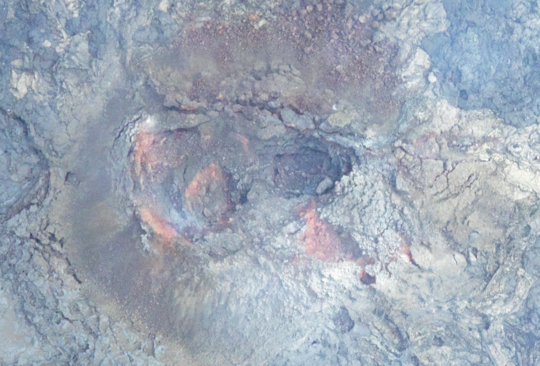
Aerial photo of the northernmost crater at the eruption site, taken on Sunday 18 April. Judging from the picture, there seems to be no activity in the crater. (Photo: Icelandic Institute of Natural History).
Power of the eruption can be estimated from satellite information
To assess the power of the eruption, it is also possible to use information from satellites that detect heat radiated from the Earth's surface. Such measurements can be seen, for example, on the website of the MIROVA project (Middle InfraRed Observation of Volcanic Activity), which analyses and publishes near real-time information on deviations in thermal radiation from the Earth's surface.
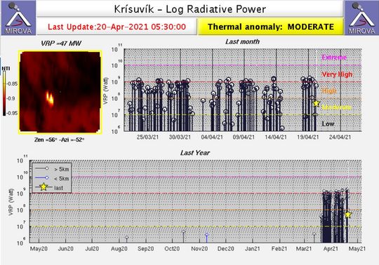
Overview from the MIROVA website showing temperature deviations over the eruption sites. (Photo: MIROVA)
An animated summary of how the lava field from the eruption sites has developed. The outlines of the lava field are based on measurements from the Icelandic Institute of Natural History, with additional processing from the National Land Survey of Iceland and the Institute of Earth Sciences at the University of Iceland.
A summary from the Institute of Earth Sciences states that the average lava flow for the first 30 days of the eruption was 5.6 m3/s. Compared to most other Icelandic eruptions, the flow is remarkably low and relatively stable. The measurements on the lava now show that there has been some increase in the last 1-2 weeks. The average flow for the first 17 days was 4.5-5 m3 / s, but for the last 13 days it is close to 7 m3 / s.
A comparison with other eruptions shows that despite the increase, the flow is now only about half of what occurred on average during the first 10 days at Fimmvörðuháls in the spring of 2010, which was a small eruption. A comparison with Holuhraun shows that the current flow is 6-7% of the average lava flow during the six months that the eruption lasted. In terms of lava flow, the closest historical example would be the effusive phase of the Surtsey eruption, which began in April 1964 and continued until the end of the eruption in June 1967.
The power of the eruption has increased in parallel with the opening of more craters
Below you can see an overview published on 19 April by the Institute of Earth Sciences of lava discharge from the Fagradalsfjall eruption. The results represent the total flow from all craters over a six-day period, 12-18 April. This is a slight increase from the average flow in the eruption and confirmation that in parallel with the opening of more craters last week, the power of the eruption has increased somewhat, the area of the lava has reached 0.9 km2 and the total volume is now over 14 million cubic meters.
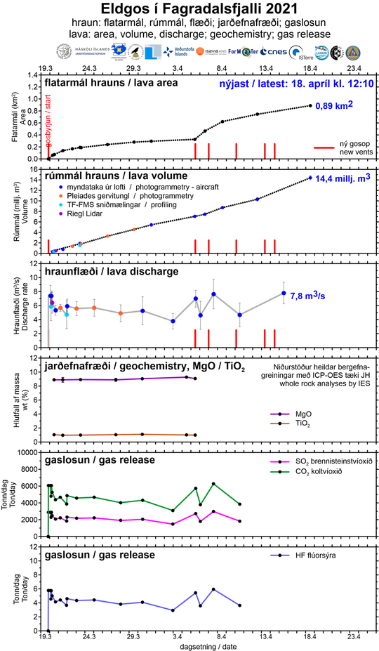
The graphs above show, among other things, the development of the area and volume of lava and lava flow. Development of the area of the lava is not as "linear" as the development of the volume, but that is because to begin with, the lava field grew in thickness within Geldingadalur rather than spreading out. Ongoing work on processing geochemical and gas data is being done, and the graphs will be updated as soon as it is completed.
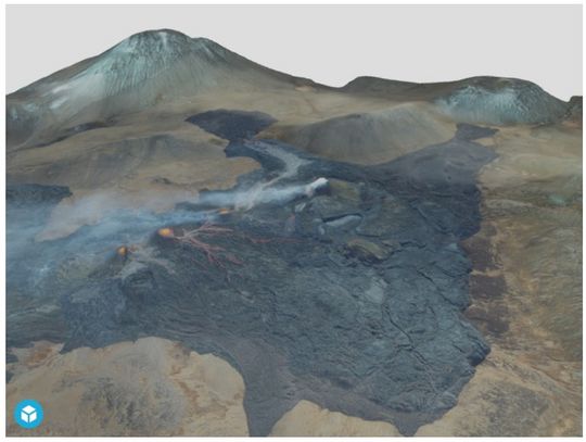
3D model of the eruption sites
The Icelandic Institute of Natural History operates an aerial photography studio where geological mapping is carried out using aerial photographs to create three-dimensional models. This method has been useful in mapping the eruption area by Fagradalsfjall, but with the 3D models it is possible to estimate the volume and thickness of the lava, lava flow and much more. You can view the 3D model by clicking on the image below.
Updated 08.04 12:25
The lava flow from the latest
eruption fissure seems to mostly flow down into Geldingadalir. This third eruption
fissure opened at midnight on the 6th of April and is between the
two existing fissures. Rescue teams from the Icelandic Association for Search
and Rescue had detected subsidence in the area on the 6th of April about
420 meters northeast of the original eruption area in Geldingadalir, which was
about 150m long and about 1 meter deep.
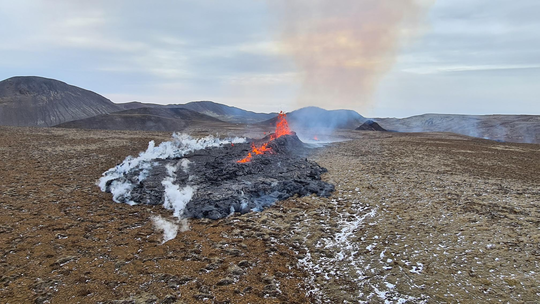
In the photos that were taken during the reconnaissance flight on the 7th of April it can be seen that the lava fields from the three eruption fissures are now merging. Lava from the third fissure has flowed south into Geldingadalir and northeast towards the eruption site above Meradalir. There is a continuous lava field between the three eruption sites, which in fact belong to the same volcanic fissure over the magma intrusion at Fagradalsfjall.
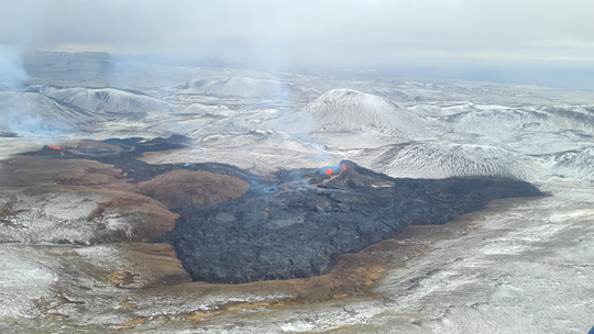
A continuous lava field between the three eruption sites at Fagradalsfjall. (Photo: Almannavarnir / Björn Oddsson)
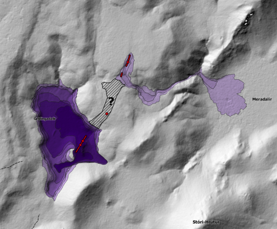
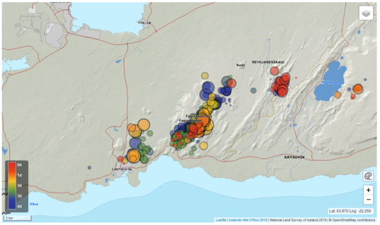
Overview map showing the location of the three eruption sites in red and lava flow from them as the situation was on the 7th of April.The lava flow from the latest fissure has not been mapped exactly. The outlines of the lava have been approximated from aerial photographs of the region.
Updated 05.04 at 15:40
Photos of two new volcanic fissures near to the initial eruption site in Geldingadalir, located approximately 700 meters NE of the craters in Geldingadalir. The new fissures are in total 200 meters long. The lava from the fissures is non viscous and flows fast in a narrow lava-river into Meradalir valley, east of the new fissures, where a new lava field is forming.
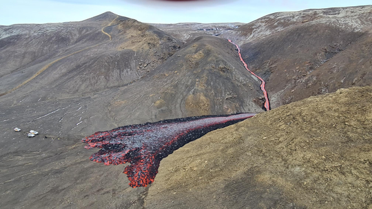
Photos: Björn Oddsson/Department of Civil Protection and Emergency Management
Updated 05.04 at 14:15
A new additional fissure opened at ca. 12:00 hrs today near the initial eruption site in Geldingadalir. First estimates of the length of the fissure is ca. 200 meters, and the middle of the fissure is approximately 1 kilometer NE of the eruption site in Geldingadalir. The lava from the new fissure flows toward Meradalir valley, east of the new fissure.
Helicopters from the Icelandic Coast Guard are at the new eruption site to make sure the area is evacuated. An airplain with scientists is on its way to the fissure for evaluating more presicely the location and the size of the new fissure.
Because of the lack of ash and tephra emission in the atmosphere, the aviation color code for Keflavik airport remains orange as there are no imminent hazard for the aviation.
A live stream from the new fissure can be seen at RUV 2 .


