Uplift continues beneath Svartsengi
The dike intrusion on April 1 is the largest since November 2023
Updated April 8, at 16:15 UTC
- Ongoing microseismic activity near the dike, but gradually decreasing
- Clear evidence of continued uplift beneath Svartsengi
- Uplift is currently occurring at a faster rate than after previous eruptions
- Too early to determine how magma accumulation rates will evolve
- Approximately 30 million cubic meters of magma left the magma chamber on April 1, making this the largest magma intrusion since November 10, 2023
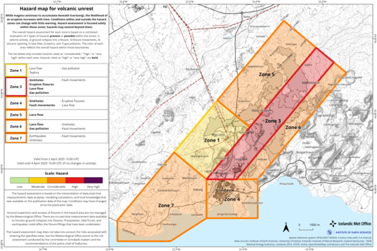
- Hazard assessment has been updated and is valid until April 15, if conditions remain unchanged
- As long as magma continues to accumulate beneath Svartsengi, further intrusions and even eruptions remain likely
Deformation measurements clearly show that uplift beneath Svartsengi is ongoing. The current uplift rate is faster than that observed following previous eruptions. This may be explained by the large volume of magma — around 30 million cubic meters — that was released from the system during the most recent event.
However, it is still too early to predict how the rate of magma accumulation will develop. Past events have shown that accumulation rates typically decline as more time passes between eruptions. At least a week, and possibly several weeks, will need to pass before we can evaluate if — and how — the rate of accumulation will change.
Based on the data currently available, magma continues to flow into the Svartsengi system, indicating that the volcanic activity in the Sundhnúkur crater row area is not over. As long as this accumulation continues, repeated intrusions — and potentially eruptions — remain likely. The Icelandic Meteorological Office continues to monitor the area closely and assess possible scenarios based on the latest data.
Displacement at GPS station SENG
in the Svartsengi area since November 11, 2023, in the north, east, and
vertical directions (top, middle, bottom). The bottom graph shows vertical
displacement in millimeters, with the most recent measurement (April 7) marked
by a green dot.
Red lines indicate the timing of the last eight eruptions (December 18, 2023;
January 14; February 8; March 16; May 29; August 22; November 20, 2024; and
April 1, 2025).
Blue lines mark the timing of magma intrusions that occurred without leading to
an eruption (November 10, 2023, and March 2, 2024).
Dike intrusion largest since November 2023
According to model calculations, approximately 30 million cubic meters of magma flowed from the magma chamber beneath Svartsengi into a newly formed dike on April 1. This marks the largest magma intrusion since November 10, 2023.
Microseismic activity continues to be measured along the northern part of the April 1 dike. Additionally, triggered earthquakes are still being detected near Reykjanestá and west of Kleifarvatn. While deformation has decreased around the northern part of the dike, deformation continues to be detected near the dike itself on GPS stations and satellite imagery.
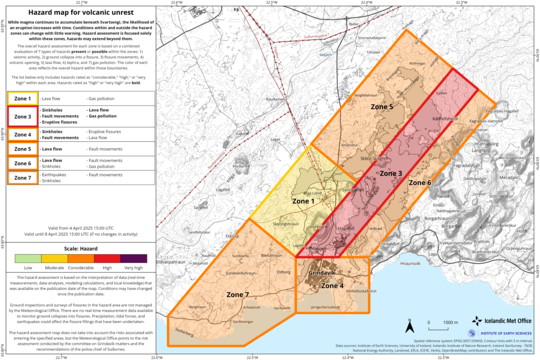
Updated hazard assessment
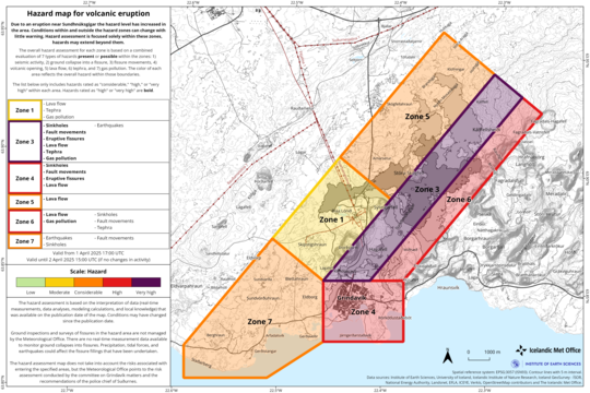
The hazard assessment has been updated and is valid until April 15, provided no major changes occur.
Significant changes have occurred across nearly all zones since the last assessment:
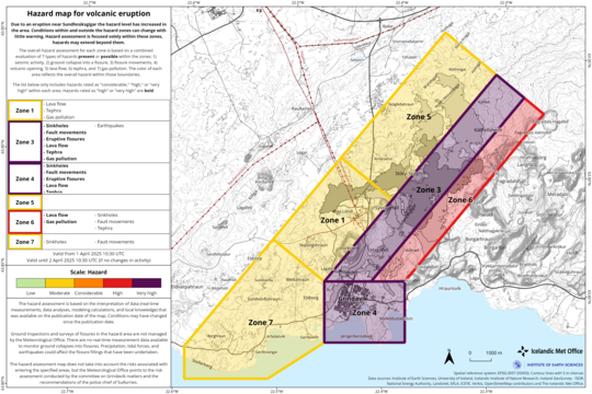
- Zone 3 (Sundhnúkur crater row) has been downgraded from „high“ (red) to „considerable“ (orange)
- Zone 4 (Grindavík), as well as Zones 5, 6, and 7, have moved from „considerable“ (orange) to „moderate“ (yellow)
- Zone 1 remains at „moderate“ (yellow)
Despite the reduction in hazard levels in many areas, there is still a notable risk of ground collapse into existing faults.

Updated April 4, at 14:55 UTC
- Indications that uplift has resumed in Svartsengi
- Seismic activity near the dike has decreased
- Deformation measurements still show movement at GPS stations around the northern part of the dike
- Uncertainty remains about the coming days, and magma movements within the dike cannot yet be ruled out
- Triggered seismic activity at Trölladyngja last night, the largest measuring 3.9 in magnitude
- The hazard assessment has been updated and is valid until April 8 unless conditions change
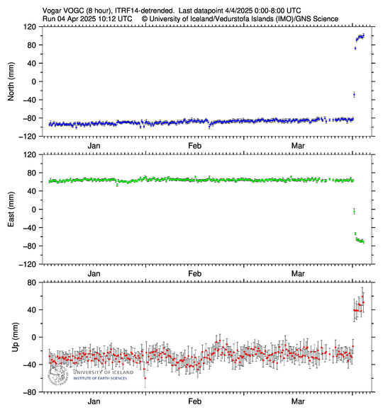
GPS measurements indicate that uplift may have resumed in Svartsengi, as shown in the accompanying figure. The most likely cause is continued magma accumulation beneath Svartsengi, though part of the uplift may be attributed to the effects of the dike formation on April 1. This is because when dikes form, they push the crust away on either side. At this stage, it is difficult to determine the rate of magma accumulation, and it may take up to a week to assess how it evolves beneath Svartsengi.
Deformation data also shows that movement continues at GPS stations around the northern part of the dike, including in Vogar and near Keilir. Satellite images showing changes between April 2 and 3 at 16:00 confirm this movement. The same data also reveals measurable fault displacements of a few millimetres in the eastern part of Grindavík.
The graphs show 8-hour solutions for GPS stations SENG (located in Svartsengi) and VOGC (in Vogar). The data presents displacements in the north, east, and vertical directions (top, middle, bottom). The vertical motion at SENG shows signs that uplift has resumed after considerable subsidence when magma entered the dike on April 1. Data from VOGC still reflects movements related to the northern part of the dike, although the station is located nearly 7 km from it.
Decreasing seismicity but deformation and microseismic activity persist
Seismic activity over the northern part of the dike continues to decrease, though small earthquakes are still being recorded in the area. During the past night and this morning, about 20 to 30 earthquakes were measured per hour, most below magnitude 1.0. At peak activity, over 100 earthquakes were detected per hour. Most earthquakes are spread from Stóra-Skógfell in the south to just north of Keilir. Their depths are mostly between 4 and 6 km, which has remained stable in recent days.
The vast majority of magma that left Svartsengi is now within the dike formed on April 1, in some places at depths of around 1.5 km, according to modeling data. Deformation due to the dike and microseismic activity in its northern part remain unusually high, even though it is decreasing. Due to this, there is still considerable uncertainty about developments in the coming days, and magma movements within the dike cannot be ruled out.
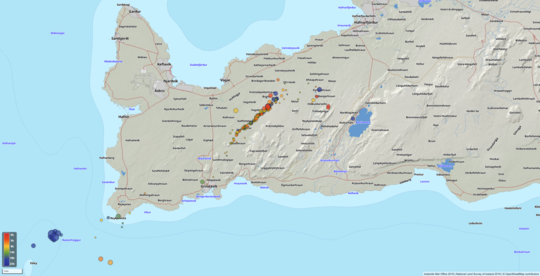
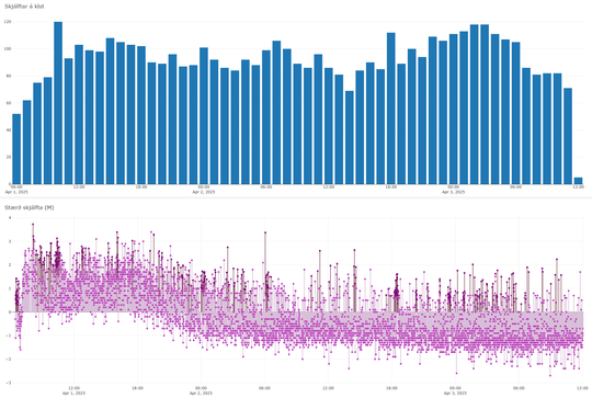
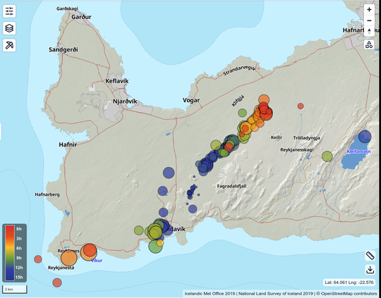
The map shows the location of all reviewed earthquakes on the Reykjanes Peninsula over the past 24 hours. It also shows preliminary estimates of the dike's location, extending from Grindavík in the south to an area about 3 km northwest of Keilir. The blue bars show the number of earthquakes—both reviewed and unreviewed—per hour since the morning of April 1. The total number of earthquakes has declined over the past day. The bottom graph shows the magnitudes of the earthquakes, which have continued to decrease. Darker circles indicate reviewed events; lighter ones are unreviewed.
Swarm near Trölladyngja likely triggered by stress changes
At 17:30 on April 3, a notable earthquake swarm began near Trölladyngja, northwest of Kleifarvatn. The largest eartquake in the sequence occurred around 23:00 and measured M3.9. Since the swarm began, six earthquakes above magnitude 3 have been recorded. Many reports were received that the events were felt in populated areas. After midnight, activity in the area began to decline. The earthquakes near Trölladyngja are likely triggered earthquakes due to stress changes following the dike intrusion on April 1. There remains a possibility of similar-sized triggered events in nearby areas like Trölladyngja and Reykjanestá in the coming days and weeks. Setja link hér
Hazard assessment unchanged
The Icelandic Meteorological Office has updated the hazard assessment, and the overall hazard level for all zones remains unchanged from the previous version. The assessment is valid, unless otherwise noted, until 15:00 on April 8.
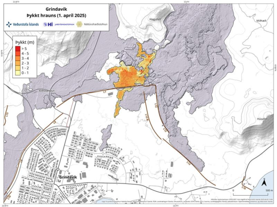
Data collected by experts from the Icelandic Institute of Natural History during an aerial survey of the eruption site in the afternoon of April 1 has been processed. The resulting map shows that the lava field formed during the 6-hour eruption covered about 0.23 km² and had an average thickness of approximately 1.7 m.
Updated April 3, at 15:25 UTC
- The event is not over, as a number of small earthquakes are still being measured along the northern part of the magma intrusion.
- The likelihood of a new vent opening in the northeastern part of the intrusion decreases with time.
- Significant uncertainty remains regarding the continuation of this event, as a high number of small earthquakes are still detected at the northern end of the dike.
- Magma flow from beneath Svartsengi into the Sundhnúkur crater row has stopped.
- Deformation measurements over the coming days and weeks will shed a light on how magma accumulation beneath Svartsengi is evolving.
- Deformation data indicate that the northernmost part of the dike has reached a region just under 4 km north of Keilir.
Analysis of webcam footage, drone videos, and gas measurements show that the eruption, which began at 9:44 AM on April 1st, ended around 4:45 PM the same day. The eruption lasted just over 6 hours, making it the shortest eruption in the current eruption cycle at the Sundhnúkur crater row.
However, the event is not yet over, as small earthquakes continue to be measured along the dike, particularly north of Stóra-Skógfell, although seismic activity has decreased over the past 12 hours. Little earthquake activity is recorded in the southern part of the dike.
Seismic activity has also decreased in areas such as Reykjanestá, Eldey, and Trölladyngja, where triggered seismicity has occurred in recent days.
The map shows the location of all reviewed earthquakes on the Reykjanes Peninsula during the past 24 Hours. The blue bars indicate the number of earthquakes per hour since the morning of April 1. The chart shows that the number of earthquakes remains considerable. However, the graph below, which displays the magnitudes of the earthquakes, indicates that their size has generally decreased over the past 24 hours.
Unlikely that a new vent will form
Subsidence is not measured in Svartsengi anymore, which indicates that magma flow from Svartsengi into the dike has decreased to such a degree that surface deformation is no longer detected by GPS stations.
It becomes increasingly unlikely that a new vent will form in the northeastern part of the dike, although uncertainty remains as long as earthquake activity persists in the area. This assessment is based on the lack of continued subsidence in Svartsengi, implying that magma influx into the dike has become minimal. Furthermore, most of the magma has already moved from Svartsengi into the dike, making it unlikely that sufficient pressure remains to force magma to the surface.
Deformation measurements in the coming days and weeks will clarify how magma accumulation under Svartsengi develops.
The hazard assessment issued on April 2nd remains in effect until 3:00 PM on April 4th, unless conditions change.
New graben formed at the northern end of the new dike
Deformation measurements show that the northernmost part of the dike lies in an area just under 4 km north of Keilir. Satellite imagery and modeling indicate that the magma intrusion came closest to the surface about 5 km northeast of Stóra-Skógfell, where its uppermost section lies at a depth of around 1.5 km.
Satellite images also show fault movements above the northern section of the dike, in the area northeast of Litla-Skógfell, where a new graben (subsidence valley) has formed.
Fault movements have also been observed within the town of Grindavík, although to a lesser extent than those seen during the January 2024 eruption. Additionally, faulting was recorded at Reykjanestá following a magnitude 5.3 earthquake that occurred in the afternoon of April 1st.
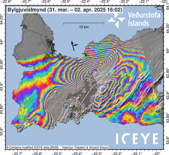
The interferogram illustrates surface deformation that occurred between March 31 and April 2. The white fault line marks the estimated location of the magma intrusion that formed on April 1. Additional white lines indicate where surface fault movements were detected. The greatest deformation has been measured in areas where the colored fringes are most tightly spaced. This includes the Svartsengi area, where the land subsided by approximately 25 cm, and on both sides of the northern part of the dike. The gray overlay shows the extent of lava flows formed since the beginning of the eruption episode in December 2023, while the orange overlay shows the lava field produced by the April 1 eruption.
Updated April 2, at 15:15 UTC
- No eruptive activity has been observed at the fissure since yesterday afternoon, although glowing is still visible in the new lava field.
- The dike that formed yesterday is nearly 20 km long and is the longest one observed since the seismic unrest began in November 2023.
- Since yesterday morning, the ground has subsided more than 25 cm at the GPS station in Svartsengi (SENG) and continues to subside, although at a much slower rate.
- Approximately 90% of the magma that had accumulated in the magma chamber beneath Svartsengi since the end of the previous eruption in December 2024 has already transferred into the dike that formed on April 1.
- Over time, the likelihood of a new eruptive opening forming along the dike is decreasing, though it cannot be ruled out due to ongoing microseismicity in the area.
- Displacements were recorded on several GPS stations within Grindavík in connection with fault movements.
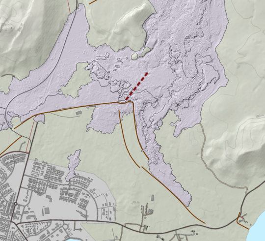
No activity has been observed at the eruptive fissure since yesterday afternoon, though glowing is still visible in the newly formed lava. The area remains unstable and hazardous. Measurements show that the lava volume erupted yesterday was about 0.4 million cubic meters. This estimate is based on data collected by experts from the Icelandic Institute of Natural History during an aerial survey of the eruption site yesterday afternoon. The lava field formed is the smallest one observed since the eruption sequence at Sundhnúkur crater row began in December 2023. Its volume is approximately 1/6 of the lava field from the January 2024 eruption, which was the second smallest event in the sequence.
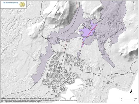
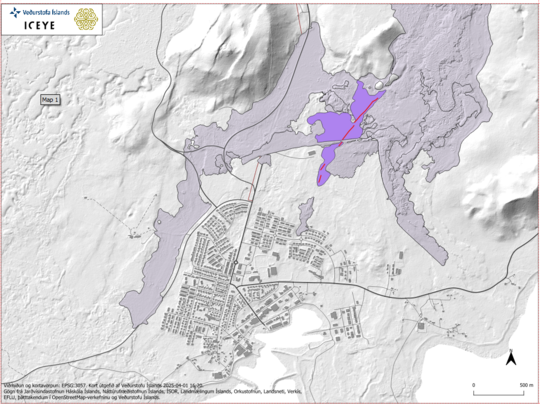
The map shows the extent of the lava field formed during
yesterday's eruption, based on measurements by the Icelandic Institute of
Natural History.
Despite the small lava field, the dike that formed yesterday is nearly 20 km long—the longest since the onset of seismic unrest in November 2023. This suggests that the vast majority of magma that left the magma chamber beneath Svartsengi, about 90% of the volume accumulated since the previous eruption in December 2024, was used in forming the dike, and only a small portion reached the surface north of Grindavík.
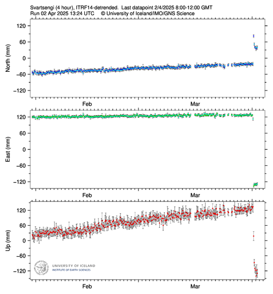
Since yesterday morning, ground subsidence of more than 25 cm has been recorded at the GPS station in Svartsengi (SENG). The latest GPS measurements, from 8 a.m. this morning, confirm that subsidence is ongoing, though it has slowed significantly. Most of the magma that had accumulated since the last eruption has now moved from Svartsengi into the newly formed dike.
The graph shows 4-hour solutions for the GPS station SENG, located in Svartsengi. The data displays displacements in the north, east, and vertical directions (top, middle, bottom).
In connection with faulting within Grindavík, displacements were measured at several GPS stations in the town. The largest displacements occurred in the eastern part of the town. For instance, vertical movement of just over 10 cm and horizontal displacement of 5–8 cm was recorded at a station on Austurvegur. In the western part, horizontal movement of about 6 cm was measured at the station on the western edge of town. The total displacement observed within Grindavík since the onset of the event yesterday morning is up to about 50 cm, distributed over several faults in the area.
Seismicity and deformation have decreased since last night
Since the magma intrusion began around 06:30 yesterday morning, approximately 2,400 earthquakes have been detected in connection with the dike formation. The dike propagated steadily northeast until about 21:00 last night. Since then, activity has remained focused north of Fagradalsfjall and extending past Keilir. Seismic activity continues at a moderate level, but earthquake magnitudes have generally decreased compared to yesterday, as illustrated in the accompanying figure. Deformation measurements also indicate that the dike extends beyond Keilir, aligning with the distribution of seismicity.
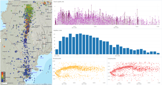
Seismic activity above the dike from 06:30 on April 1 to 12:00 on
April 2. Top right: earthquake magnitude. Middle graph: number of earthquakes
per hour. Lower left: earthquake latitudes. Lower right: earthquake longitudes.
Likelihood of new eruptive opening decreasing over time
Given the current development in the southern part of the dike—marked by the absence of eruptive activity and low seismicity—it is increasingly unlikely that the eruption which began yesterday will reinitiate. Regarding the northeastern part of the dike, the likelihood of a new eruptive opening is also considered lower with time, although it cannot be ruled out due to persistent microseismicity in the area.
Deformation measurements over the coming days will provide a clearer picture of whether magma continues to flow from Svartsengi into the dike and how magma accumulation beneath Svartsengi evolves.
The hazard assessment has been updated and is valid until 15:00 on Friday, April 4, if no changes occur. Key updates include:
- Zone 3 (Sundhnúkur crater row): Overall hazard level now assessed as high (red), down from very high (purple).
- Zone 4 (Grindavík): Hazard level reduced to considerable (orange), from high (red), as the likelihood of a new eruptive opening has decreased.
- Zone 6: Hazard level now considered considerable (orange), previously high (red).
Geological inspection and monitoring of faults within Grindavík does not fall under the jurisdiction of the Icelandic Meteorological Office. However, GPS data from the IMO indicate fault movements within Grindavík related to the dike intrusion that formed on April 1.
The hazard map issued by the Icelandic Meteorological Office does not take into account the personal risk associated with entering the marked zones. The IMO refers instead to the risk assessment prepared by the Government Task Force on Grindavík and the recommendations of the Police Commissioner of Suðurnes.
Updated April 1st at 21:40 UTC
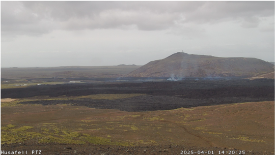
Based on webcam observations, no eruptive activity is visible at the fissure that opened this morning just north of Grindavík. Only minor glow is detectable here and there along the eruption fissure and within the lava field.
Seismic activity and deformation due to magma movement continue at the northeastern end of the dike that formed today. In total, seismic activity has been recorded across a roughly 20 km long area, extending from the southern end of the eruptive fissure to the location where seismicity is now most intense.
The earthquakes are still occurring at considerable depth, and there are no signs that the migrating magma is approaching the surface. According to model calculations from this afternoon, approximately 15 million cubic meters of magma had flowed from Svartsengi into the dike beneath the Sundhnúkur crater row, with only a small fraction of that volume having reached the surface. Prior to the eruption, around 22 million cubic meters of magma had accumulated in the magma reservoir beneath Svartsengi since the last eruption, suggesting that there may still be potential for further magma movement.
As long as seismic activity and deformation continue within the dike, the possibility of a new eruptive fissure opening must be considered. The most likely location for such an opening is in the area where seismic activity is currently most intense. Should an eruption occur, it may be accompanied by significant seismic activity, potentially noticeable to residents in Vogar.
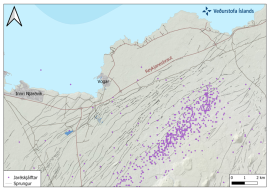
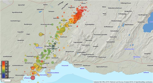
Map showing reviewed earthquakes on the Reykjanes Peninsula since 6 AM, April 1st.
Updated April 1st at 18:30 PM
Volcanic activity north of Grindavík continues to decrease, with little visible activity on webcams or in recent drone footage. However, seismic activity continues. Earthquake activity near the southern part of the magma dike, close to Grindavík, has decreased, while activity at the northern end of the dike continues with similar intensity and has shifted even further north in recent hours. The seismic activity now extends almost 9 km farther north than the northernmost eruption fissure formed during the August 2024 eruption. The largest earthquakes have been around magnitude 3 and have been felt in Vogar, which is about 7 km northwest of the active area.
The map shows the location of earthquakes recorded today, April 1, 2025, along with known fault lines in the area. It indicates that the dominant fracture orientation in the region is NE-SW. No known fractures are mapped in the Vogar area.
Deformation measurements show that magma is still flowing from Svartsengi into the dike beneath the Sundhnúkur crater row. The seismic activity suggests that the magma is moving northeast. Earthquakes are occurring at depths of approximately 4–6 km, and deformation data from this area is currently being analyzed. As long as significant seismic activity and deformation continue, there remains a possibility that magma could reach the surface again in the Sundhnúkur crater row or nearby where activity is most concentrated.
The following map shows the lava extent as of 12:34 PM, formed by the eruption that began this morning. The map is based on ICEYE satellite imagery.
The hazard assessment has been updated and is valid until 3:00 PM tomorrow, April 2, unless conditions change. The hazard level for Zone 3 (Sundhnúkur crater row) remains very high (purple). In Zone 4 (Grindavík), the hazard level has been downgraded to high (red), due to reduced risk from ashfall and gas pollution. Changes have also been made to the hazard levels in Zones 7 and 5, which have been raised from moderate (yellow) to considerable (orange) due to ongoing seismic activity near the northeastern end of the dike.
Updated April 1st at 14:40 PM
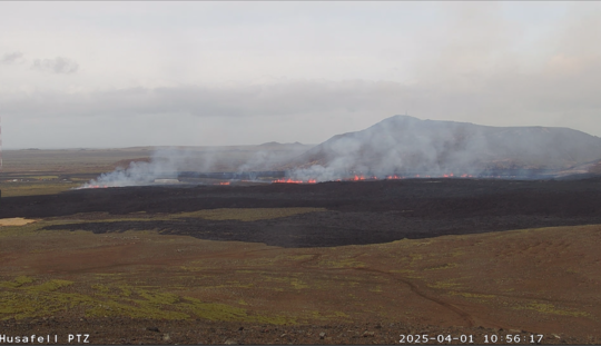
According to webcam observations, the volcanic activity appears to have decreased significantly in the past hour.
Seismic activity is still ongoing but is mostly located at the northern and southern part of the dike intrusion.
Deformation measurements still show continued movement to the northeast, indicating that magma is still flowing into the dyke
Updated April 1st at 12:35 PM
The total length of the eruptive fissure is now about 1,200 meters and continues to extend southward.
The Icelandic Meteorological Office received a report that a hot water pipeline has broken in the northern part of Grindavík. This confirms that significant fault movements have occurred within the town.
Ongoing seismic activity is being recorded along the entire dike intrusion, with the most intense activity at the northeastern end. The intrusion now extends over 3 km further to the northeast than observed in previous eruptions. Deformation data also show continued displacement toward the northeast. This indicates that magma is still moving through the dike intrusion.
Seismic activity over the dike intrusion since 4 AM this morning, April 1st.Updated April 1st at 11:00 AM
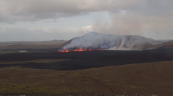
The fissure has extended southward. A new eruptive fissure has opened a few hundred meters inside the protective barriers north of Grindavík – between the barriers and the town itself.
(The new fissure opening is on the left on the photo).
The weather forecast indicates southwesterly winds today (Tuesday), carrying volcanic gas northeastward, including over the capital area. Winds are expected to calm in the evening, concentrating the gas pollution mainly around the eruptive fissure. Tomorrow morning (Wednesday), winds will shift to northwesterly and later westerly, dispersing the gas southeastward and later eastward – including over Þorlákshöfn and the Ölfus region. The gas dispersion forecast can be found here.
Seismic activity continues at the southern end of the magma intrusion and also north of Stóra-Skógfell. Earthquakes have also been measured near Reykjanestá, which are likely triggered (fault-slip) earthquakes due to stress release related to the activity in the Sundhnúkur crater row. More information about the activity can be found here .
Updated April 1st at 10:30 AM
Initial reports from the Coast Guard surveillance flight indicate that the fissure is now about 700 meters long and has remained relatively stable, although it cannot be ruled out that it may extend further north or south. Seismic activity and deformation measurements continue to show ongoing activity.
The hazard assessment has been updated. The alert level for the Sundhnúkur crater row (Zone 3) has been raised to very high hazard (purple), and in Grindavík (Zone 4) has been increased from high hazard (red) to very high hazard (purple). This hazard assessment is valid until April 2 at 10:30 AM, unless conditions change.
Updated April 1st at 10:00 AM
The fissure is now about 500 meters long and has reached through the protective barrier north of Grindavík. The fissure continues to grow, and it cannot be ruled out that it may continue to open further south.
Updates from the Coast Guard helicopter are still awaited.
The map shows the fissure that is now about 500 m. long.
Updated April 1st at 9:45 AM
An eruption has started just north of the protective barrier near Grindavík.
A Coast Guard helicopter will take off shortly to confirm the exact location and size of the eruption.
The length of the magma intrusion under the Sundhnúkur crater row that has already formed is about 11 km, which is the longest measured since November 11, 2023.
More information will be available soon.
Given the current wind direction, gas pollution from the eruption will be carried northeast toward the capital area. It is not possible to predict the intensity of the pollution.
Here is a link to the Icelandic Met Office's gas dispersion forecast.
Updated April 1st at 9:20 AM
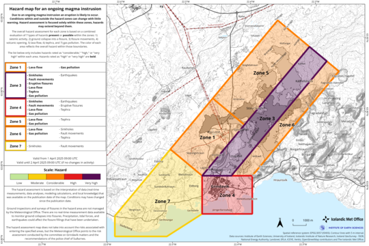
The hazard assessment has been updated due to a magma intrusion in the Sundhnúkur crater row. As a result of the intrusion, the likelihood of a volcanic eruption has increased.
The hazard level in area 3 has been raised from “high hazard” to “very high hazard” (purple), and in area 4 (Grindavík), the hazard level has been raised from “considerable hazard” (orange) to “high hazard” (red).
The updated hazard assessment is valid until 9:00 AM on April 2, provided that conditions do not change.
Updated April 1st at 8:20 AM
Signals from GPS meters are stronger than those observed during recent events in the Sundhnúkur crater row. This indicates that a considerable amount of magma is currently on the move.
The signals show that magma is moving both to the northeast and southward toward Grindavík. At this stage, it is not possible to determine where the magma will emerge, but it's noteworthy that the southern displacement of deformation signals was not observed during the eruption that began in November 2024.
Emergency responders in Grindavík have reported that earthquakes can be felt in the town, and signs of deformation are also visible there, suggesting that fault movements could occur within the town itself.
Updated on April 1st at 7.25 AM
An earthquake swarm began at around 6:30 AM this morning on the Sundhnúks Crater Row. The swarm is located between Sýlingarfell and Stóra-Skógfell, in a similar are as seen prior to previous eruptions.
The earthquake swarm was followed by a clear change in deformation and pressure changes in boreholes operated by HS Orka. Both independent measurements were a clear sign of the onset of a magma intrusion.
No magma has reached the surface as of now, but an eruption is likely to occur.
The new will be updated.
