
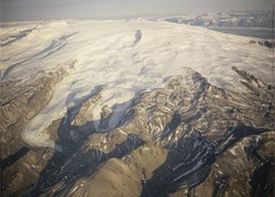
New seismic stations installed around Öræfajökull
Seismic activity has been increasing in Öræfajökull volcano in the recent months and the Icelandic Meteorological Office (IMO) has responded by strengthening the surveillance in the area.
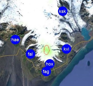
In the last week of October, staff from IMO installed two new seismic stations near the glacier Öræfajökull: at Háöxl (Hox), south of the glacier; and at Kvísker (Kvi), on the eastern side of the glacier. In addition earlier in the month, IMO gained access to the seismic station, owned by the British Geological Society, located near Falljökull (Fal), west of Öræfajökull. This station, which was installed for ice-quakes research, has proofed to be very beneficial to locate earthquakes in this volcanic area.
When looking at long-term changes in the seismicity, activity has been increasing in Öræfajökull since 2016. In June and since early September this year, the activity has increased still further. The new stations are therefore an important addition to the pre-existing monitoring network for improving the sensitivity of the surveillance system. The current seismic network provides better information on the seismicity, it particularly detects small earthquakes (magnitude between M0 and M1), and also allows a better assessment of either location and magnitudes of the earthquakes. There is still considerable uncertainty in the depths of the earthquakes, but their seismic waveforms are consistent with a source located in the crust at a few kilometers depth. The 48-hours seismicity is available on the IMO website and updated in real-time.
Scientists from IMO met on the 17 of October with colleagues from the Institute of Earth Sciences of the University of Iceland and representatives of the Civil Protection Department of the National Police. The purpose of the meeting was to review all the available monitoring data for this volcano, including deformation data coming either from satellite-based (InSAR) and ground-based measurements (GPS). The deformation data set analysed for the period 2015-2017 is consistent with a slight uplift of the area in correspondence of Öræfajökull volcano. Such a trend could also be attributed to glacial changes on-going over the entire Vatnajökull area. The deformation data did not show any acceleration in the process associated with the increasing seismicity observed in June and in September this year.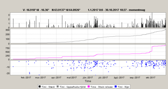
Seismicity in Öræfajökull volcano in 2017: Top, the graph shows the magnitude of each detected earthquake; the next graph shows the cumulative number of earthquakes; the third graph shows the cumulative seismic moment. From this graph it is well visible the M3.5 earthquake measured at the beginning of October 2017. This is the largest earthquake detected in Öræfajökull volcano since the beginning of the measurements; the last graph shows the depth of earthquakes in kilometers


