
Hydrology of Eyjafjallajökull
Measurements at river Markarfljót
Meltwater from the eruption in Eyjafjallajökull runs down glacier Gígjökull, which protrudes from the ice cap to the north, and into river Markarfljót.
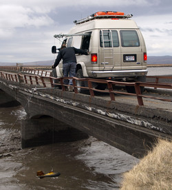
A team of specialists from IMO went there for hydrological measurements 28 April 2010, in order to verify indications from continous automatic gauges and from web-cameras.
Discharge of meltwater from Gígjökull increased signifcantly that day, reaching levels not exceeded since 16 April.
Meltwater draining beneath the old Markarfljót bridge, approximately 18 km downstream from Gígjökull, had a temperature of over 11°C.
The discharge was measured twice: The flood that began at Gígjökull at around 11:30, reached a peak discharge of 250 m3/s two hours later at the old bridge. Both 28 and 29 April, mean discharge from Gígjökull was 130-150 m3/s, which was higher than the days before.
Additionally, the electrical conductivity of Krossá and Steinholtsá rivers remained high.
For more photos of the hydrological measurements, see article.
For earlier news of Eyjafjallajökull eruption, and of Fimmvörðuháls before that, click 2010.


