
Severe weather tomorrow
Warning for Saturday 29th December
Issued: 28. december 2012 at 11:30 UTC
The Icelandic Met. Office has issued a warning of severe weather in the Westfjords in the afternoon and tonight; and tomorrow in the northern and the western parts of Iceland. People are advised against travelling in the northern og western parts of the country tonight and tomorrow.
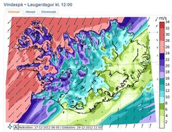
The forecast: NE 20-25 m/s and snow in the Westfjords in the afternoon. N and NE 18-33 m/s (Beaufort force 9 and in places hurricane force, 12) in the western part tonight and tomorrow, most windy in the Westfjords and the southern side of Snæfellsnes. Much weaker winds in the East, Southeast and in forecast area South (Suðurland). Moderate or heavy snowfall in the northern half, rain or sleet in the east and south parts. Slowly decreasing winds and precipitation in the west part on Saturday evening but increasing winds in the east, up to 15-20 m/s.
Avalanche danger: It has been snowing in mountains and on mountain slopes for the past few days (and heavy snowfall is forecast) and the risk of avalanches can increase quickly with increasing winds and blowing snow. The Met. Office recommends that skiers, snowmobiles and others traveling in the mountains avoid known avalanche slopes and do not travel where avalanches can fall. Also, avoid stopping vehicles on parts of the roads where there is a risk of avalanches.
Coastal warning: Combination of high tide, low pressure, big waves and storm surge can create danger areas along the northern and western coastline.
Repeat: No travelling weather in the northern og western parts of the country tonight and tomorrow. Please keep up to date on weather and travel conditions.
Forecasters on duty: Björn Sævar Einarsson, Elín Björk Jónasdóttir and Árni Sigurðsson.
Avalanche specialist on duty: Sveinn Brynjólfsson.


