
Earthquake sequence east of Grímsey
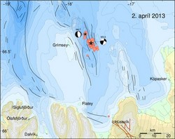
A M5.5 earthquake occurred at 00:59 on 2nd April 2013 about 15 km east of Grímsey island offshore North Iceland. The earthquake was felt at Grímsey, Húsavík, Raufarhöfn, Mývatnssveit, Akureyri and Sauðarkrókur. Several hundruds aftershocks have been detected following the mainshock. The source region is located on a fault system that reaching from Öxarfjörður to the north of Grímsey, the so called Grímsey lineament. Another M4.7 earthquake followed this morning at 08:56 and was located about 7.5km northwest of the night's main event.
Both mainshocks are shown as black stars in the map, aftershocks that have been manually revised so far are shown as red dots. The M5.5 mainshock is located on a north-south striking left lateral strike-slip fault, see black lines in the map. The M4.7 event around 9 am was located on a normal fault to the north-west.
This cluster at about 7.5 km distance to the main cluster was most likely activated due to static stress changes induced by the M5.5 earthquake. The mechanisms are illustrated in the figure below: M5.5 strike-slip faulting (sniðgengishreyfingar) on the right, M4.7 normal-faulting (siggengishreyfingar) on the left.

Earthquake sequences are common in this area. It is impossible to predict the further development of the seismic activity and how it might influence faults in its vicinity. Further large events can not be excluded.


