
The segmented dyke intrusion explained
An article in Nature on the rifting event at Bárðarbunga
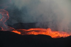
Advanced online publication in Nature today reports research by an international team of geoscientists on the formation of the intrusive dyke which extends 45 km in the subsurface from the Bárðarbunga central volcano to the eruptive site in Holuhraun. There, the eruption has been ongoing for more than 100 days.
The paper in Nature reports how the dyke formed mostly over two weeks prior to the onset of main eruptive activity. A model for the dyke also explains unusual and varying direction of dyke segments, that relate to interaction of topography and stresses in the ground caused by divergent plate movements in Iceland.
The model was made by joint interpretation of crustal deformation results, both from GPS geodetic measurements and interferometric analysis of satellite synthetic aperture radar images, and earthquake observations.
The team includes 37 scientists from the University of Iceland, the Icelandic Meteorological Office and eight universities in other countries. This is part of the research project FUTUREVOLC funded by the European Union. The team was coordinated by Freysteinn Sigmundsson at the Institute of Earth Sciences, University of Iceland.
The seismic swarm began just outside the northeast caldera rim, but already on the first day the seismicity propagated a few kilometers to the southeast. There it took a sharp bend towards northeast, marking the start of the dyke's journey towards the eruption site at Holuhraun. A short eruption occurred at the beginning of day fourteen, but the eruption that is still on-going started in the early hours of the sixteenth day, on 31 August. At about the same time as the eruption started, the seismicity on the caldera rim increased. Over 70 earthquakes over magnitude 5 have been recorded since then.


