
Warning against heavy rainfall
Warm southerlies and snow melt
Heavy rainfall and mild conditions are forecast for west, south-west, south, and south-east Iceland on Saturday 14 February, lasting until late afternoon on Sunday.
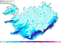
In these regions, the heaviest rainfall is expected around mountains and ice caps, where cumulative rainfall and snow melt amounts could exceed 100 mm over 24 hours (see map).
The map shows accumulated runoff (precipitation and melt water) in millimeters from 1PM Friday 13 February 2015 until noon Sunday 15 February. Please note that this forecast is only for the next 48 hours and that runoff will continue on Sunday.
Rising stream- and river levels are expected on the Snæfellsnes peninsula, around the Eyjafjallajökull and Mýrdalsjökull ice caps, and south of the Vatnajökull ice-cap. Travellers are cautioned against fording rivers in these regions.
It is advised to check drainage and keep it clear of leaves, rubbish, ice and the like in order to prevent water damage.
The southerlies that cause these changes may reach storm conditions (over 20 m/s) in West- and Northwest Iceland when rushing down from the mountains. They may also give rise to very sharp gusts of wind.
Late on Sunday afternoon winds will calm down and cool and then turn into southwesterly showers and/or hail.


