
Warning due to intense rainfall
Rising river levels, possible landslides and mudflows
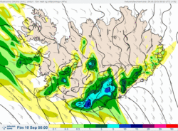
It should be noted that this week's weather is dominated by wet and windy conditions due to a series of low-pressure systems. A deep low resulted in storm-force south-easterly winds (20 - 25 m/s) yesterday that affected southern and western regions. Prolonged rainfall is continuing to affect the west, south, and south-east of the country.
The storm will be followed closely by another low tonight, Wednesday evening, 9 September, which will bring intense rainfall to south-east Iceland and, for a time, the Snæfellsnes peninsula. Rising stream and river levels are expected on the southern coast from Wednesday afternoon and throughout Thursday, from Eyjafjallajökull eastwards to Djúpivogur in the East Fjords. In mountainous coastal regions, intense rainfall could trigger hazardous landslides and mudflows without warning.
All travel plans this week should be made with the latest weather warnings in mind. Travellers are advised to stay away from all watercourses during the coming days. We strongly advise against crossing streams and rivers in the above-mentioned regions.


