The weather in Iceland in 2016
A short overview
The year 2016 was very warm in Iceland. It was the warmest year on record in all stations in North-West part of Iceland and one of the warmest in other parts of the country. During the first two months of the year temperature were close to long-term means, but the last three months of the year were particularly warm. Wind speed was slightly lower than average. During late winter to mid-summer conditions were rather dry, but the autumn was very wet, especially in the southern part of Iceland.
Temperature
The annual average in í Reykjavík was 6.0°C, 1.7°C above the 1961 to 1990 mean. This is the 21st consecutive year with an annual average above this mean and in a joint second to third place (in a series extending back to 1871) along with 2014. The record year 2003 was slightly warmer.
The longest continuous series of temperature measurements in Iceland comes from Stykkishólmur, where 2016 was the warmest since the start of measurements (in 1846) with annual temperature of 5.5°C, which is +2.1°C above the mean. In Akureyri the average was 4.9°C, +1.7°C above the mean, there 2014 was warmer.
The highest annual temperature, 7.1°C, was measured at Steinar near the South coast, but the lowest, -0.1°C, at the mountain station Þverfjall in the northwest. The lowest annual temperature in inhabited areas, 1.8°C, was measured at Möðrudalur in the north-eastern uplands.
Relative to the 1961 to 1990 mean it was coldest in Vestmannaeyjar off the Southern coast, but warmest in the island of Grímsey off the Northern coast.
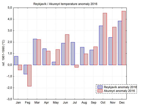
The temperature was above normal in Reykjavík in all months except February, but it was below normal at Akureyri in January, February and also slightly below in July. The last three months of the year were exceptionally warm.
The highest maximum temperature of the year was measured at Egilsstaðir in the East on 3 June, 24.9°C, but the lowest minimum was -25.3°C in Svartárkot in the north-eastern upland on 30 March.
The absolute maximum in Reykjavík was 21.3°C, on 27 July. The absolute minimum in Reykjavík was -10.3°C on 31 January.
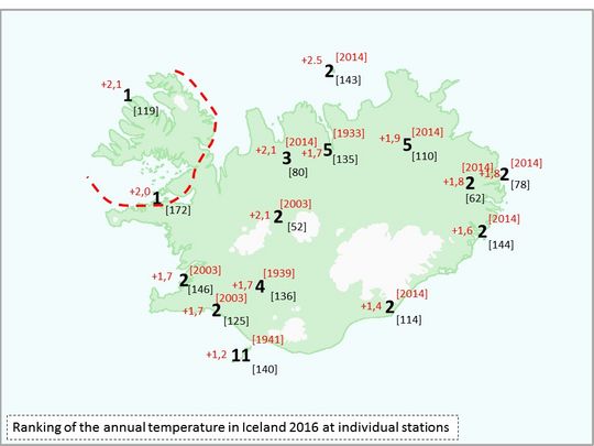
The year was the warmest on record in the north-western part of the country. The large bold numbers show the ranking of the year‘s temperature at selected stations. The red numbers indicate the deviation from the 1961 to 1990 normal, the red numbers in the brackets the warmest year of the series at that station and the numbers in black the number of years in the station series.
Precipitation
The annual total precipitation was above the 1971 to 2000 mean at most stations.
The total in Reykjavík was 933.9 mm, 14 per cent above the 1971 to 2000 mean. In Akureyri the total was 629.2 mm, 21 per cent above the 1971 to 2000 mean.
The number of days with precipitation equal to or exceeding 1.0 mm was 153, 5 which is above the 1961 to 1990 average, but the fewest since 2010. In Akureyri these days were 109 in 2016, six more than in an average year.
The absolute maximum 24-hr precipitation was measured on 12 October at Nesjavellir in the Southwest, 157.3 mm. The absolute maximum in Reykjavík was 31.1 mm on 6 October.
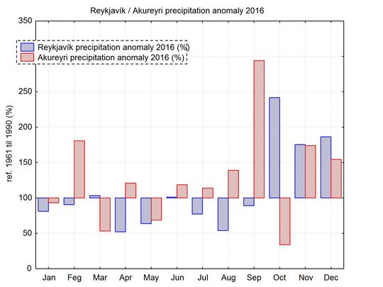
In Reykjavík (blue bars) the precipitation was near normal or slightly below during the first nine months of the year but far above the norm during the last three months of the year. In Akureyri (red) the precipitation was heavy in February, November and December, and particularly heavy in September. October was relatively dry in Akureyri.
Snow
Snow conditions in Reykiavik were heavy during winter of 2015 to 2016 , especially in December and February. There was, however, not much snow in March. Snow cover during the last months of the year was unusually light in the whole country.
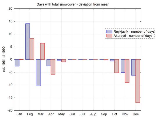
Snow conditions were heavy in both Reykjavík and Akureyri in February, the number of days with snow covering the ground was above normal - but in March the snow cover was well below normal in Reykjavík and during the last months of the year the snow cover was particularly light.
Bright sunshine duration
There were 1302.2 hours of bright sunshine during the whole year, 34 above the 1961 to 1990 mean. In Akureyri the total was 1150.0, 105 above the mean.
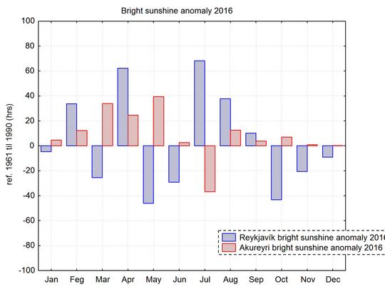
April and July were particularly sunny in Reykjavík (blue bars), but May, June and October rather gloomy. July was gloomy in Akureyri (red) but in most of the other months the sunshine duration was above the average.
Sea level pressure
The annual average in Reykjavík was 1005.5 hPa, 0.4 hPa below the 1961 to 1990 mean.
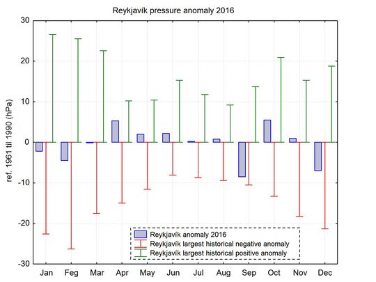
Sea level pressure was not far from average during most months of 2016, except during September when it was on the low side.
The absolute highest pressure of the year was measured at Reykjavík airport on 31 December, 1040.1 hPa, but the lowest at Gufuskálar in the west on 20 December, 944.1 hPa.
Wind speed and direction
The mean wind speed was below average and stormy days fewer than usual.
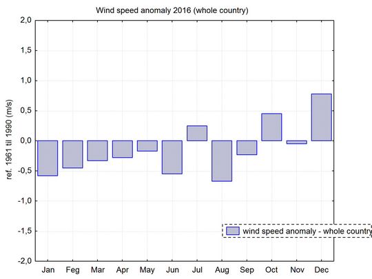
The wind speed was below the 1961 to 1990 mean during the first six months of the year and also in August and September. It was slightly above normal in July and October but well above normal in December.
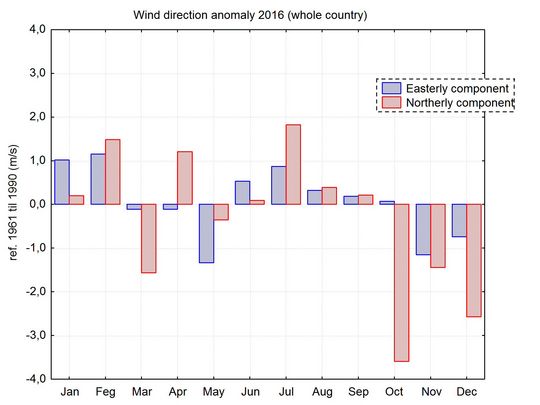
All wind observations at manned stations are decomposed into an easterly and northerly component and compared to the 1961 to 1990 mean. Winds from the East and North are defined positive, but West and South winds negative. Northerly winds (red) prevailed in February, April and July, but Southerly in March and the last three months of the year. Westerly winds were above average in May, November and December, but Easterly in January and February, and also in July.
A short overview of the individual months
January
January was favourable, the temperature in most districts was slightly above the 1961 to 1990 average. It was cold in the northern inland. Precipitation was below average in most of the country and in a part of the northwest it was the driest January over a long period.
February
February was cold, especially in the inland areas. Snow conditions were heavy, but the winds were mostly light so the snow did not cause considerable problems for communication or outdoor activities. The precipitation was above the mean in the Northeast and East, but close to average in the Southwest and West. In spite of the generally light winds there were two significant windstorms, one from the E on the 4th and 5th and from the SE and later SW and W on the 15th and 16th.
March
The weather was favourable for most of the month, mainly warm except for a few days in the beginning and the end of the month. Stormy weather prevailed for a few days near the middle of the month, especially on the 12th to 15th. There was some wind related damages, especially in the Northwest.
April
The weather was favourable, and the temperature well above the 1961 to 1990 mean. It was very wet in the East, but dry and sunny in the West.
May
A favourable month, but a bit on the dry side for the spring vegetation. The temperature was above the average. In spite of the dry weather cloud cover was persistent.
June
A favourable month, a bit on the dry side during the first half. It was very warm, the warmest June on record in the central highlands.
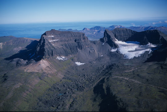
Dyrfjöll and Stórurð. Photo: Oddur Sigurðsson.
July
A very favourable month in the South and West, but wet and gloomy in the Northeast. There was excessive precipitation in places in the East, but below average in the West.
August
This was a warm and favourable month in most areas, rather dry and warm.
September
It was very wet in the North and East, but in other areas the weather was favourable. The winds were unusually light considering the season. The agricultural harvest was good.
October
October was exceptionally warm and in many areas the warmest on record. The weather was mainly favourable as well, except for very heavy precipitation for a period in the South and West, the monthly totals were record high at a few stations. The month was totally frost-free in most coastal areas, which is unusual.
November
The month was a warm one with heavy precipitation and the weather was favourable but dark and gloomy.
December
The warm weather continued until just before Christmas, in the East this was the warmest December on record. The precipitation was heavy and the weather was very dark. The only storms of significance occurred just after Christmas. The whole country had white Christmas – the only snow of the whole second part of the year.
