
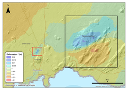
Update on the activity in the Reykjanes peninsula
Since the intense seismic swarm started in Fagradalsfjall on
the 18th of July, the activity has been slowly decreasing over time. The acquisition of recent satellite images enabled mapping
of new surface deformation in the area associated with the sequence of large
earthquakes which occurred between the 18th and 20th of July. The satellite
data processing clearly shows a deformation signal corresponding to
approximately 3 centimeters of movement along a NE-SW oriented fault in the
region of Fagradalsfjall (See black box in the figure above. Click here for a larger view ). This fault was identified during the 2017 earthquake swarm
which also occurred in this area. The current earthquake activity is interpreted to be part of a
larger scale volcano-tectonic reactivation event in the Reykjanes peninsula.
Localised subsidence signal detected at Svartsengi
The satellite images also reveal a localised subsidence signal in the Svartsengi area (See picture above - red box). The observed subsidence commenced between the 16th-18th July (slightly before the occurrence of the large tectonic earthquakes in Fagradalsfjall) and the next satellite image (expected for the end of this week) will confirm if the deflation is still ongoing or if this has stopped. Deformation modelling will be undertaken to verify the origin of this signal.
No significant changes are reported regarding the geochemical measurements performed this week on the peninsula. In addition the geothermal power plant in Svartsengi reports no changes in their routine measurements.
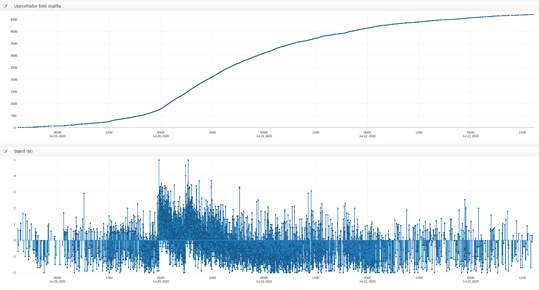
Seismicity in the Reykjanes peninsula since the
18th of July.
The ongoing activity on the Reykjanes peninsula, which commenced at the end of 2019, reflects a widespread volcano-tectonic reactivation of a large section of the peninsula, currently spanning Eldey in the west to Krýsuvík in the east. Activity (including additional earthquakes and magmatic intrusions) is likely to continue, with the focus switching between different areas along the peninsula.
Possible hazards:
- Landslides and falling rocks might be triggered by earthquakes, most likely in regions with unstable slopes, steep cliffs and loose material
- Earthquakes up to M5.5-6 might occur in areas along the Reykjanes peninsula with the potential to effect the captial region
- Gas accumulation in depressions might occur in the event of very still wind conditions
Scenarios:
The same scenarios identified since the beginning of the ofReykjanes peninsula volcanic unrest are all still valid.


