
Home-page - Icelandic Meteorological Office
Weather forecast
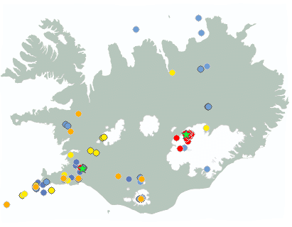
Weather forecast for the next 24 hours
Light northerly or variable winds, mostly cloudy, with some patchy, light rain, but partly fair in the west parts and isolated afternoon showers, with a risk of local downpours. Starting to rain in the northeast late evening.
North 8-15 m/s tomorrow, windiest by the east coast and wiedly rain or drizzle, but fair in the south and west. Temperatures 6 to 17 deg. C, mildest in South- and West-Iceland.
Forecast made 28.07.2026 05:09
If the map and the text forecast differs, then the text forecast applies
Forecast for station - 1
Forecast for station - 2
Forecast for station - 3
Forecast for station - 4
Forecast for station - 5
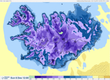
Maximum wind in Iceland today
| Lowlands | |
|---|---|
| Highlands | |
|---|---|
Maximum and minimum temperature in Iceland today
| Lowlands | |
|---|---|
| Highlands | |
|---|---|
Maximum precipitation in Iceland today
| Lowlands | |
|---|---|
| Highlands | |
|---|---|
Maximum wind in Iceland during the last hour
| Lowlands | |
|---|---|
| Highlands | |
|---|---|
Maximum and minimum temperature in Iceland during the last hour
| Lowlands | |
|---|---|
| Highlands | |
|---|---|
Maximum precipitation in Iceland during the last hour
| Lowlands | |
|---|---|
| Highlands | |
|---|---|
Preliminary results
Earthquakes
Earthquakes during last 48 hours. at 28 Jul 07:15 GMT

Biggest earthquakes during the last 48 hours
| Size | Time | Quality | Location |
|---|---|---|---|
| 5.2 | 28 Jul 05:36:38 | Checked | 3.6 km NE of Bárðarbunga |
| 4.1 | 27 Jul 00:36:17 | Checked | 3.5 km NE of Skeggi á Hengli |
| 3.1 | 26 Jul 22:19:55 | Checked | 575.0 km NNE of Kolbeinsey |
Specialist remark
A M5.2 earthquake took place in Bárðarbunga at 5:36am today. An earthquake of this magnitude last took place on June 13 and they happen regularly in the Bárðarbunga caldera.
An earthquaek of magnitude 4.1 was measured at Nesjavellir in Hengill at 00:36 on July 27th and was felt well in SW Iceland. Some light aftershock activity has been observed. This is the largest earthquake in this area since 1998 when a magnitude 4.6 earthquake was measured in Nesjavellir. Seismicity is however common in the area.
Written by a specialist at 28 Jul 06:35 GMT
Week overview -
Earthquake activity throughout the country is described in a weekly summary that is written by a Natural Hazard Specialist. The weekly summary is published on the web every Tuesday. It covers the activity of the previous week in all seismic areas and volcanic systems in the country. If earthquake swarms are ongoing or significant events such as larger earthquakes have occurred during the week, they are specifically discussed. More
Hydrology
Average flow and temperature last 24 hours
| River | Place | Flow | Water temperature |
|---|
Remarks of a specialist
The MET Office has received reports of sulfur smell near the Múlakvísl and Jökulsá á Sólheimasandi glacier river. In addition over the past few days, an increased level of volcanic gases (CO2 and H2S) have been measured at Láguhvolar. It is important for people to exercise caution due to gas pollution, especially near the riverbanks and the river's source.
Due to malfunction we have turned off the service publishing hydrological data on the map. Instead see the data using our Rauntímavöktunarkerfi.
Written by a specialist at 28 Jul 07:18 GMT
Avalanche forecasts are now published on Icelandic Met Office’s new website:
New avalanche pages on gottvedur.is/en
News from the Icelandic Met Office’s landslide monitoring service will continue to be published on vedur.is (in Icelandic)
News
Increased hazard due to changing conditions at the margin of Sólheimajökull glacier
Recent changes at the terminus of Sólheimajökull call for increased caution. Unstable glacier ice and rockfall from the surrounding slopes may pose a risk to people visiting the area.
Read more
Situation on the Reykjanes Peninsula
Magma accumulation and ground uplift continue beneath Svartsengi. The average rate of magma accumulation over the past few weeks has remained steady.
The most likely scenario remains continued slow magma accumulation, eventually leading to a new dike intrusion and possibly a volcanic eruption.
Read more
Ground uplift and magma accumulation continue beneath Svartsengi
The Icelandic Met Office receives international grant to strengthen aviation safety in relation to volcanic hazards
In October 2025, the Icelandic Meteorological Office (IMO) received a grant of ISK 147 million from the International Civil Aviation Organization (ICAO) for four new development projects in the fields of volcanic hazards and aviation safety. The projects involve, among other things, the development of new measurement methods, automatic analysis of eruption plumes, coordination of responses among European volcano observatories, and research into the effects of sulphur dioxide (SO₂) on aviation.
Read more
IMO expert to lead international collaboration on geohazards

Nordic report on the impacts of a AMOC tipping urges stronger mitigation, monitoring and preparedness
The report A Nordic Perspective on AMOC Tipping reviews the current state of science on the impacts of potential Atlantic Meridional Overturning Circulation (AMOC) collapse and provides recommendations for policy actions.
Read moreShort articles
HARMONIE - numerical weather prediction model
HARMONIE is a numerical weather prediction model (NWP) that is non-hydrostatic and convection-permitting. It is operated at 2.5 km horizontal resolution over a domain that covers Iceland and the surrounding seas. At this resolution it is possible to simulate explicitly some processes that are important for clouds and precipitation as well as meteorological phenomena related to up- and downdrafts. In order to simulate the interaction between the atmosphere and the surface, the model takes into account different types of land surface as well as processes in and at the surface.
Read moreNew publications and research
- Guðrún Nína Petersen (2025). Alviðruhamrar - Meteorological conditions
- Michelle Parks, Freysteinn Sigmundsson, Vincent Drouin, Ásta R. Hjartardóttir, Halldór Geirsson, Andrew Hooper, Kristín S. Vogfjörð, Benedikt G. Ófeigsson, Sigrún Hreinsdóttir, Esther H. Jensen, Páll Einarsson, Sara Barsotti & Hildur M. Friðriksdóttir. (2023).
- Sahar Rahpeyma, Benedikt Halldórsson, Birgir Hrafnkelsson & Atefe Darzi. (2023). Frequency-dependent site amplification functions for key geological units in Iceland from a Bayesian hierarchical model for earthquake strong-motions.
- Sara Klaasen, Solvi Thrastarson, Yesim Cubuk-Sabuncu, Kristín Jónsdóttir, Lars Gebraad, Patrick Paitz & Andreas Fichtner. Subclacial volvano monitoring with fiber-optic sensing: Grímsvötn, Iceland. (2023).
- Ismael Vera Rodriquez, Marius P. Isken, Torsten Dahm, Oliver D. Lamb, Sin-Mei Wu, Sigríður Kristjánsdóttir, Kristín Jónsdóttir, Pilar Sanchez-Pastor, John Clinton, Christopher Wollin, Alan F. Baird, Andreas Wuestefeld, Beat Booz, Eva P.S.Eibl, Sebastian Heimann, Bettina P. Goertz-Allmann, Philippe Jousset, Volker Qye, Vala Hjörleifsdóttir, Anne Obermann. (2002).
- Lamb, O.D., Gestrich, J.E., Barnie, T.D., Jónsdóttir, K., Ducrocq, C., Shore, M.J., Lees, J.M., Lee, S.J (2022). Acoustic observations of lava fountain activity during the 2021 Fagradalsfjall eruption, Iceland. Bull Volcanol 84, 96. doi.org/10.1007/s00445-022-01602-3
- Freysteinn Sigmundsson, Michelle Parks, Andrew Hooper, Halldór Geirsson, Kristín S. Vogfjörd, Vincent Drouin, Benedikt G. Ófeigsson, Sigrún Hreinsdóttir, Sigurlaug Hjaltadóttir, Kristín Jónsdóttir, Páll Einarsson, Sara Barsotti, Josef Horálek & Thorbjörg Ágústsdóttir (2022). Deformation and seismicity decline before the 2021 Fagradalsfjall eruption. Nature 609, 523–528. doi.org/10.1038/s41586-022-05083-4
Search
Contact IMO
© Veðurstofa Íslands | Bústaðavegi 7- 9 | 105 Reykjavík | Phone 522 6000 | Fax: 522 6001
Recording 902 0600 | SSN 630908-0350
Contact us | Employees | Terms and conditions | Sitemap


