
Home-page - Icelandic Meteorological Office
Weather forecast
Weather forecast for the next 24 hours
Southerly or variable wind 3-8 m/s with light scattered rainshowers in the afternoon, but increased precipitation in the evening.
More westerly tomorrow, partly cloudy and isolated rainshowers, but southeasterly 5-10 in the westernmost part and light precipitation.
Temperature 7 to 15 deg. C tomorrow, warmest in the east part.
Forecast made 19.06.2025 04:39
If the map and the text forecast differs, then the text forecast applies
Forecast for station - 1
Forecast for station - 2
Forecast for station - 3
Forecast for station - 4
Forecast for station - 5
Maximum wind in Iceland today
| Lowlands | |
|---|---|
| Highlands | |
|---|---|
Maximum and minimum temperature in Iceland today
| Lowlands | |
|---|---|
| Highlands | |
|---|---|
Maximum precipitation in Iceland today
| Lowlands | |
|---|---|
| Highlands | |
|---|---|
Maximum wind in Iceland during the last hour
| Lowlands | |
|---|---|
| Highlands | |
|---|---|
Maximum and minimum temperature in Iceland during the last hour
| Lowlands | |
|---|---|
| Highlands | |
|---|---|
Maximum precipitation in Iceland during the last hour
| Lowlands | |
|---|---|
| Highlands | |
|---|---|
Preliminary results
Earthquakes
Earthquakes during last 48 hours. at 19 Jun 04:40 GMT

Biggest earthquakes during the last 48 hours
| Size | Time | Quality | Location |
|---|---|---|---|
| 3.4 | 18 Jun 22:26:22 | Checked | 3.9 km N of Krýsuvík |
| 2.9 | 17 Jun 15:58:15 | Checked | 4.4 km SW of Hrómundartindi |
| 2.1 | 18 Jun 09:39:08 | Checked | 33.1 km N of Borgarnes |
Specialist remark
This evening at 22:26 an earthquake of M3.4 was detected in Móhálsadalur just W of Krýsuvík and it was felt all over Reykjanes peninsula and in the capital area. Many aftershocks have followed. Earthquakes are common in the area.
On June 16th at 18:05 an earthquake of M3,7 was measured near Grjótárvatn. This is one of the biggest earthquakes measured in that area since the ongoing activity started in 2021. The 15th of April and the 8th of May earthquakes of M3,7 were also measured. The earthquake was felt in nearby areas.
Yesterday at 15:58 an earthquake of M2,9 was measured in the Hengill area. The earthquake was felt in nearby areas.
Written by a specialist at 18 Jun 22:40 GMT
Week overview -
Earthquake activity throughout the country is described in a weekly summary that is written by a Natural Hazard Specialist. The weekly summary is published on the web every Tuesday. It covers the activity of the previous week in all seismic areas and volcanic systems in the country. If earthquake swarms are ongoing or significant events such as larger earthquakes have occurred during the week, they are specifically discussed. More
Hydrology
Average flow and temperature last 24 hours
| River | Place | Flow | Water temperature |
|---|
Remarks of a specialist
Due to malfunction we have closed the service with the water stations on the map. In stead it is possible to see this in the link. Rauntímavöktunarkerfi.
Written by a specialist at 12 Jun 20:29 GMT
Avalanches
Avalanche bulletins for selected areas
The avalanche bulletin is at a regional scale. It does not necessarily represent avalanche danger in urban areas.
| Region | N/A | N/A | N/A |
|---|---|---|---|
|
Southwest corner
|
|
|
|
|
Northern Westfjords
|
|
|
|
|
Tröllaskagi
|
|
|
|
|
Eyjafjörður (experimental)
|
|
|
|
|
Eastfjords
|
|
|
|
News
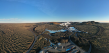
Continued Uplift in Svartsengi
Update 3. June
Uplift and magma accumulation continue beneath Svartsengi. However, the rate of magma accumulation continues to gradually decrease compared to the rates observed in April and the first half of May. If magma accumulation continues at a similar pace as in recent weeks, the likelihood of a magma intrusion or eruption is expected to increase as autumn approaches. Changes in the rate of uplift—and therefore magma accumulation—beneath Svartsengi could, however, influence this assessment.
Read more
The most significant May heatwave ever recorded in Iceland
Temperatures
reached or exceeded 20°C at several weather stations for 10 consecutive
days.
May temperature records were repeatedly broken at weather stations across the country.
A new national May temperature record of 26.6°C was set at Egilsstaðir Airport on May 15th.
Read more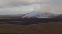
Uplift continues beneath Svartsengi
Updated April 8, at 16:15 UTC
Deformation measurements clearly show that uplift beneath Svartsengi is ongoing. The current uplift rate is faster than that observed following previous eruptions. This may be explained by the large volume of magma — around 30 million cubic meters — that was released from the system during the most recent event.
However, it is still too early to predict how the rate of magma accumulation will develop. Past events have shown that accumulation rates typically decline as more time passes between eruptions. At least a week, and possibly several weeks, will need to pass before we can evaluate if — and how — the rate of accumulation will change.
Read more
Eruption at the Sundhnúkur crater row remains likely
Updated 25. March at 15:00 UTC
GPS deformation data shows that magma continues to accumulate beneath Svartsengi, although the pace of land uplift has slightly decreased in recent weeks. Despite the slower uplift, experts still consider it likely that a magma intrusion and/or eruption will occur along the Sundhnúkur crater row.
Read more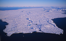
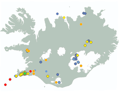
Earthquake swarm ongoing offshore Reykjanestá
At around 14:30 yesterday (12 March 2025), a rather intense earthquake swarm began offshore Reykjanestá. The swarm was most intense at the beginning when about 50 – 60 earthquakes were recorded in the first few hours. As the day progressed, the activity decreased but then increased again shortly before midnight when an earthquake of magnitude 3.5 occurred. When the activity increased again in the evening, it shifted slightly westward as the image shows (blue circles indicate the location of earthquakes that occurred at the beginning of the swarm yesterday, while yellow and red ones show earthquakes from late last evening and night).
Read more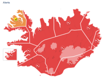
Red weather warnings in effect today – no travel recommended
A southerly storm or violent storm is expected later today and tomorrow, with very strong wind gusts, widely 35 – 45 m/s and especially near mountains, but locally exceeding 50 m/s. Considerable or heavy rain is expected in the south and the west regions of the country. More details can be found here.
Read moreShort articles
Avalanches in Iceland
Catastrophic avalanches in the villages Súðavík, 16 January 1995, and Flateyri, October 1995, which killed 34 people and caused extensive economic damage, totally changed the view regarding avalanche safety in Iceland.
New publications and research
- Michelle Parks, Freysteinn Sigmundsson, Vincent Drouin, Ásta R. Hjartardóttir, Halldór Geirsson, Andrew Hooper, Kristín S. Vogfjörð, Benedikt G. Ófeigsson, Sigrún Hreinsdóttir, Esther H. Jensen, Páll Einarsson, Sara Barsotti & Hildur M. Friðriksdóttir. (2023).
- Sahar Rahpeyma, Benedikt Halldórsson, Birgir Hrafnkelsson & Atefe Darzi. (2023). Frequency-dependent site amplification functions for key geological units in Iceland from a Bayesian hierarchical model for earthquake strong-motions.
- Sara Klaasen, Solvi Thrastarson, Yesim Cubuk-Sabuncu, Kristín Jónsdóttir, Lars Gebraad, Patrick Paitz & Andreas Fichtner. Subclacial volvano monitoring with fiber-optic sensing: Grímsvötn, Iceland. (2023).
- Ismael Vera Rodriquez, Marius P. Isken, Torsten Dahm, Oliver D. Lamb, Sin-Mei Wu, Sigríður Kristjánsdóttir, Kristín Jónsdóttir, Pilar Sanchez-Pastor, John Clinton, Christopher Wollin, Alan F. Baird, Andreas Wuestefeld, Beat Booz, Eva P.S.Eibl, Sebastian Heimann, Bettina P. Goertz-Allmann, Philippe Jousset, Volker Qye, Vala Hjörleifsdóttir, Anne Obermann. (2002).
- Lamb, O.D., Gestrich, J.E., Barnie, T.D., Jónsdóttir, K., Ducrocq, C., Shore, M.J., Lees, J.M., Lee, S.J (2022). Acoustic observations of lava fountain activity during the 2021 Fagradalsfjall eruption, Iceland. Bull Volcanol 84, 96. doi.org/10.1007/s00445-022-01602-3
- Freysteinn Sigmundsson, Michelle Parks, Andrew Hooper, Halldór Geirsson, Kristín S. Vogfjörd, Vincent Drouin, Benedikt G. Ófeigsson, Sigrún Hreinsdóttir, Sigurlaug Hjaltadóttir, Kristín Jónsdóttir, Páll Einarsson, Sara Barsotti, Josef Horálek & Thorbjörg Ágústsdóttir (2022). Deformation and seismicity decline before the 2021 Fagradalsfjall eruption. Nature 609, 523–528. doi.org/10.1038/s41586-022-05083-4
Search
Contact IMO
© Veðurstofa Íslands | Bústaðavegi 7- 9 | 105 Reykjavík | Phone 522 6000 | Fax: 522 6001
Recording 902 0600 | SSN 630908-0350
Contact us | Employees | Terms and conditions | Sitemap


