
A minor eruption underway
Please see IMO's Twitter account for the latest info on earthquakes. @Vedurstofan
Updated 29.3 at 09:30
The Civil
Protection and Emergency Management's Science Board held a meeting Friday (Mars
26.) to discuss the volcanic eruption in Geldingadalir on the Reykjanes
Peninsula. A lot of data has been collected including on-site and remote
measurements along with modeling work forecasting the event's possible behavior
over the coming days. A report detailing the event's general status and
proposals for regular monitoring will be released shortly.
Both the Icelandic Met Office and the University of Iceland's Institute of
Earth Sciences regularly post results and people are encouraged to view their
web pages, twitter streams and Facebook pages.
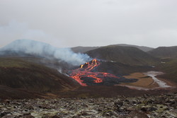
The volcanic eruption in Geldingadalir has now been ongoing for nine days. The lava is basaltic and highly fluid with little explosive activity. It is a very small eruption and the lava flow has been steady at 5-7 m3/s since its onset. Currently the extent of the lava field is within Geldingadalur but if the eruption keeps ongoing at a similar rate, it is modeled that the lava will flow east towards Merardalur valley. If the volcano continues to erupt it could eventually end up being categorized as a shield volcano. Shield volcanoes are generally formed over long time periods with lava fields extending from a few to several kilometers around its source. There is no way to tell how long the eruption will last.
The current magma is rich in MgO (8.5%) which indicates that it is from depths of around 17-20 km. There has been constant gas pollution close to the eruption site, spatially determined by local wind conditions. Gases can accumulate to life-threatening levels in certain weather conditions. There have been no indications of significant tectonic movements since the eruption started. There is currently no indication of new openings at other locations along the magma injection path.
This eruption calls for specific and targeted monitoring of the eruption itself and also of the gas´s effects on air quality and the downwind environment.
Uptdated 23.3 at 12:38
Decreasing SW-ly wind today and unhealthy air quality can be expected near the eruption site after 19:00 today. SO2 concentration close to the volcano can surpass over 9000 µg/m3, and CO2 can also gather in valleys in the landscape. It is advised to leave the area before 17:00, keeping away from valleys and following the marked path.
Updated 21.03. 17:25
The Icelandic Met Office closely monitors the development of gas pollution from the eruption in Geldingadalur. Gas pollution from the volcanoes is not expected to have a significant impact on the well-being and health of residents on the Reykjanes Peninsula and the capital area in the next few days. Weather, wind direction and pollutants (such as SO2 and CO2) from the volcanic eruption all affect the strength and distribution of the gas pollution.
The Icelandic Met Office has prepared a forecast model that predicts the probable distribution and concentration of gas pollution due to the eruption in Geldingadalur. The forecasts are updated twice a day.
Updated 21.03 13:40
The Scientific Advisory Board of the Icelandic Civil Protection met yesterday afternoon, 20 March, to evaluate the latest developments of the volcanic eruption in Geldingardalur on the Reykjanes Peninsula. The conclusion of the meeting was that the following developments are possible:- The eruption will decrease gradually and end in the coming days or weeks.
- New volcanic fissures could open at the eruption site or along the magma dike near to Mt. Fagradalsfjall.
- The likelihood of a large earthquake close to Mt. Fagradalsfjall has reduced due to the ongoing volcanic activity.
- An earthquake up to magnitude 6.5 could be triggered in the Brennisteinsfjöll volcanic system, located east of Mt. Fagradalsfjall.
The Scientific Advisory Board of the Icelandic Civil Protection warns of dangers in the area of the eruption site.
It is important to keep in mind that the vicinity of the eruption site is dangerous as sudden changes can be expected. The Scientific Advisory Board of the Icelandic Civil Protection outlined the following hazards close to the ongoing eruption:
New volcanic fissures could form in the area without notice.
- Glowing pieces of lava could fall from the edges of the lava front, and sudden lava outbreaks can be expected where new lava tongues find their way out of the lava stream. This can happen very quickly, making it difficult for people to get out of the way, even when running.
- The volcanic craters are now several meters high and can therefore be unstable and crumble without notice with the consequences that the lava flow can suddenly change direction.
- Explosions can happen where the lava flows over water-logged ground, resulting in lava being thrown in different directions.
- The lava is streaming into a closed valley. Therefore, lethal volcanic gases, many of which are heavier than air, can accumulate in low-lying areas. The danger increases in calm weather conditions.
The IMO continues to monitor gas dispersion from the eruption. It is unlikely that gas pollution will seriously affect people living in the capital region and the towns of the Reykjanes Peninsula in the coming days. However, weather conditions and the concentration of gases (e.g. SO2 and CO2) will affect the dispersion and concentration of gas pollution. The latest gas dispersion forecast is accessible at the top of the IMO website, en.vedur.is.
Updated 20.03 13:45
What we know so far
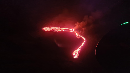
At around 20:45 UTC 19 March 2021, a volcanic eruption began at Geldingadalur, close to Fagradalsfjall on the Reykjanes Peninsula. The eruption was first seen on a web camera positioned close the mountain. It was also confirmed on thermal satellite imagery.
The eruption site is in a valley, about 4.7 km inland from the southern coast of the peninsula. The coastal town of Grindavík is the closest populated region to the eruption site, located approximately 10 km to the southwest.
The eruption is considered small at this stage and the eruptive fissure is appr. 200 m long. The area of the lava is covering an area that is appr. 500 m wide and considered less than 1 km2. Lava fountains are small and lava flows are currently a very local hazard. The seismic activity is minor and spread around the Fagradalsfjall area.
The aviation colour code for Keflavik international airport has been lowered to orange as there is no indication of production of ash and tephra and no imminent hazard for the aviation.
Volcanic gas (SO2) has been detected at the source of the eruption. A model for gas dispersion can be seen at the IMO web site. Currently, gas pollution is not expected to cause much discomfort for people except close up to the source of the eruption. The gas emissions will be monitored closely.
The area of the eruption is considered very dangerous – the eruption site can change without notice and put people at risk unexpectedly.
Reykjanesbraut – the main road from the capital region to Reykjanesbær and the international airport at Keflavík is open. However, Suðurstrandarvegur – the road along the south coastline of Reykjanes peninsula is closed between the two coastal towns Grindavík and Þorlákshöfn. Other roads and unpaved tracks in the vicinity of the eruption site are also closed.
Updated 20.03 11:10
The eruption is considered small at this stage and the volcanic activity has somewhat decreased since yesterday evening. The eruptive fissure is appr. 500 - 700 m long. The lava area is less than 1 km2 covering an area that is appr. 500 m wide. Lava fountains are small and lava flows are currently a very local hazard. The seismic activity is minor and spread around the Fagradalsfjall area. There is no indication of production of ash and tephra and currently gas pollution is not expected to cause much discomfort for people except close up to the source of the eruption. The gas emittions will be monitored closely.
The aviation color code for Keflavik international airport has been lowered to orange as there is no indication of production of ash and tephra and there is no imminent hazard for the aviation.
Reykjanesbraut – the main road from the capital region to Reykjanesbær and the international airport at Keflavík is open. However, Suðurstrandarvegur – the road along the south coastline of Reykjanes peninsula is closed between the two coastal towns Grindavík and Þorlákshöfn. Other roads and unpaved tracks in the close vicinity of the eruption site are also closed.
Updated 19.03 23:20
At around 20:45 UTC today, 19 March, a volcanic eruption began at Geldingadalur, close to Fagradalsfjall on the Reykjanes Peninsula. The eruption was first seen on a web camera positioned close the mountain. It was also confirmed on thermal satellite imagery. At the time of writing, the weather on the peninsula is wet and windy, and an orange glow can be seen in low clouds on the horizon from Reykjanesbær and Grindavík. The eruption site is in a valley, about 4.7 km inland from the southern coast of the peninsula. The coastal town of Grindavík is the closed populated region to the eruption site, located approximately 10 km to the southwest.
Earthquake activity in the region of the magma intrusion has been lower in recent days, and there is presently no intense seismicity occurring in the region. Earlier in the day, several low-frequency earthquakes were recorded below Fagradalsfjall. There are presently no reports of ash fall, although tephra and gas emissions are to be expected. In line with well-rehearsed contingency plans, the aviation colour code for the Reykjanes Peninsula has been elevated to red, signifying an eruption in progress. Additional domestic restrictions have been put in place, including the closure of Reykjanesbraut – the main road from the capital region to Reykjanesbær and the international airport at Keflavík.
Updated 18.03 at 11:33
About 400 earthquakes have been detected between midnight and seven AM on the Reykjanes peninsula. This is somewhat less seismic activity in comparison to previous mornings where the numbers have been around 1,000 earthquakes.
Yesterday around 1400 earthquakes were detected. Three were larger than magnitude 3, the largest M3.3 at 2:37AM located around 1km N of Nátthagi valley.
Today at 13:00GMT the Scientific Advisory Board of the Icelandic Civil Protection will meet to evaluate the latest monitoring data. Findings of the meeting are expected shortly after 15:00GMT.
Updated 15.03 at 11:00
Since midnight over 1000 earthquakes have been detected on the Reykjanes Peninsula, with the most active area located south of Mt. Fagradalsfjall. The largest earthquakes measured at M3,2, at 01:20 GMT last night and 07:39 GMT this morning.
Yesterday, March the 14th, over 3000 earthquakes were detected in the Reykjanes Peninsula. The largest earthquake measured M5,4 at 14:15 GMT. Yesterday evening four earthquakes measuring M3,3-M3,6 were detected, three of which were located by Mt. Fagradalsfjall and the fourth northwest of Grindavík village.
Updated 11.03 at 16:00
Over 1700 earthquakes have been measured in the Reykjanes Peninsula since midnight, few of which were over M3, the largest one measured M4,6 at 08:53 GMT this morning. As before, the magmatic activity is centered around Mt. Fagradalsfjall southwest of Mt. Keilir.
Yesterday, March 10th, 2500 earthquakes were detected in the Reykjanes Peninsula, 40 of which were over M3, the largest one measuring M5,1 at 3:14 GMT.
Yesterday, the Scientific Advisory Board of the Icelandic Civil Protection met to discuss the latest monitoring results from the seismic unrest on the Reykjanes Peninsula. The main findings of the meeting were:
- The dike intrusion is expanding with the most active magma flow centered at the southern part of it. A volcanic eruption remains a possibility as magma is still flowing into the corridor. With the ongoing activity the probability of an eruption increases day by day. It is considered very unlikely that lava from a possible eruption would reach populated areas.
- It is important to follow the activity in the southern region of Mt. Fagradalsfjall in order to evaluate whether the dike is expanding to the south.
- Latest satellite images and GPS data show that accumulation of magma is concentrated at the southern end of the dike beneath Mt. Fagradalsfjall. This is currently the most likely site for a possible eruption.
- If the dike keeps expanding and increasing stresses in the area, continuing earthquake activity that can be felt in populated areas is expected.
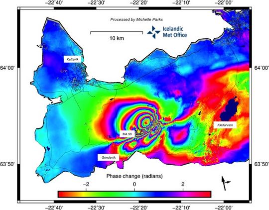
Latest satellite images and GPS data show that accumulation of magma is concentrated at the southern part of the dike beneath Mt. Fagradalsfjall. This is the most likely site for a possible eruption. InSAR image reflects changes between March 3 to March 9 2021. Image contains modified Copernicus Sentinel data [2021]
Possible eruption could begin without strong precursory signals
Currently, the magma is shallow, lying 1-1,5 km beneath the crust. Therefore, it can be expected that an eruption could start without a strong precursory signal, as the magma can easily brake through the last hundreds of meters of the crust once the critical pressure is reached. From experience of lava flow eruptions (as we might expect), the eruption tremor is weak and has a low amplitude. For this reason, the IMO has installed webcams which can be used to monitor the area, in case of an eruption will start without clear precursory signals.
Updated 09.03. at 12.30
About 5:20 this morning, the activity at Mt. Fagradalsfjall, south of the corridor, increased with a sudden increase in seismic tremor. However, the unrest soon decreased. Magma movements are a likely cause for this activity which is very localized to the south of the magma intrusion. The tremor is an indication that the intrusion is expanding.
Variable levels of seismic tremor are to be expected during such periods of seismic unrest. Therefore, it is likely that there will be periods of intense tremor interspersed with less intense activity over the coming days. A volcanic eruption remains a possibility. Therefore, scientists and civil protection staff are on alert, and they are ready to respond to a range of situations, including damaging earthquake activity or a volcanic eruption.
Possible development is as follows:
The ongoing seismic activity reduces in the coming days and weeks.
The seismic swarm will increase in intensity, possibly with an earthquake up to magnitude magnitude 6 in the area.
An earthquake up to magnitude 6.5 could be triggered in a nearby volcanic system, roughly 20 km east of the current location of the activity.
Magma intrusions continue, resulting in:
An eventual decrease in magma inflow, resulting in the magma solidifying in place without an eruption.
An effusive volcanic eruption could occur, resulting in lava flows that should not threaten inhabited areas of the peninsula.
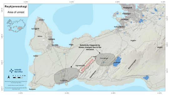
Click here to view alarger image or to download the picture. This picture shows the location where the magma chamber is forming under the earth's crust. When magma flows into the sedimentary strata and forms magma tunnels, as is currently the case in the area of unrest between Keilir and Fagradalsfjall, pressure is formed in the earth's crust. This creates tension on the east and west sides of the area of unrest.
Updated 03.03. at 19.00
At 14:20 today a sudden increase in seismic tremor was detected throughout most of Iceland's national seismic network. At the time of writing, the tremor continues although its intensity has reduced slightly. The tremor, which comprises many small, overlapping earthquakes, is sourced from a region 2 km southwest of Keilir on the Reykjanes Peninsula. Similar bursts of tremor have been observed ahead of previous volcanic eruptions in Iceland. Magma movements are a likely cause for the ongoing signal, and it is possible that an effusive (lava-producing) eruption could occur close to Keilir. However, at the time of writing, no volcanic eruption is occurring on the Reykjanes Peninsula.
Analysis of various sensor and satellite-based monitoring data continues at pace, with further spaceborne radar images becoming available late this evening. As a precaution for domestic and international air travel, the volcanic aviation colour code for the Reykjanes Peninsula has been elevated from yellow (elevated unrest) to orange (heightened unrest). The orange alert represents the third-highest level, with red reserved for an imminent or ongoing volcanic eruption.
Updated 03.03.
On 1 March, the Scientific Advisory Board of the Icelandic Civil Protection met to discuss the latest monitoring results from the seismic unrest on the Reykjanes Peninsula. In particular, the latest satellite-based radar (InSAR) image was reviewed. The displacements in the InSAR scene show more ground deformation than can be explained by the earthquake activity alone. The most likely explanation is that magma intrusions are occurring close to Fagradalsfjall, where the earthquake activity has persisted in recent days. The latest satellite results will be processed with additional geodetic modelling to better understand the causes of the ground deformation.
Given the new results discussed by the Scientific Advisory Board, it is important to consider scenarios in the development of the seismicity that could involve volcanic activity close to Fagradalsfjall.
Possible developments
- The ongoing seismicity reduces in the coming days and weeks.
- The seismic swarm will increase in intensity, possibly with an earthquake up to magnitude 6 in size nearby Fagradalsfjall.
- An earthquake up to magnitude 6.5 in size could be triggered in the Brennisteinsfjöll mountain range, over 20 km east of Fagradalsfjall.
- Magma intrusions
continue in the vicinity of Fagradalsfjall.
- The intrusive magma movements stop and eventually solidify.
- An effusive volcanic eruption could occur, resulting in lava flows that should not threaten inhabited areas of the peninsula.
The evolution of the seismicity continues to be monitored day and night, and in the event of an eruption, various contingency plans are in place.
Updated 24.02.
On February 24th 2021, two earthquakes above magnitude M5 were recorded. The larger one, M5.7, was at 10:05 and at 10:30 a M5.0 was measured. Later that day at 12:37 a M4.8 was recorded. Since the beginning of this unrest 16 earthquakes above M4 have been recorded and 90 earthquakes above M3. They have been felt widely in the SW part of the country and the larges once in the NW part as far as Ísafjörður. Note that all reviewed earthquakes have occurred on the Reykjanes Peninsula, roughly between Kleifarvatn and Svartsengi. Be aware that our web shows in accurate locations from the automatic system.
Today five earthquakes above M4 have been measured
in the northern part of Fagradalsfjall, M4,4 at 12:06, M4,0 at 12:24, M4,1 at
13:51 og M4,2 at 15:10. All those are in a similar location as the M5,7
earthquake. Our interpretation is that these are triggered earthquakes caused
by the intense activity and deformation that has occurred in the area. The
swarm is still ongoing and roughly 5000 earthquakes have been detected with the
automatic system since the beginning of the swarm.
The satellite image below displays a Sentinel-1 interferogram spanning the period 19-25th February. This shows ground deformation associated with the recent earthquake activity on the Reykjanes Peninsula and indicates this was related to a combination of movement on north-south trending faults and left-lateral movement over a large section of the plate boundary (~25 km segment - from Svartsengi to Kleifarvatn).
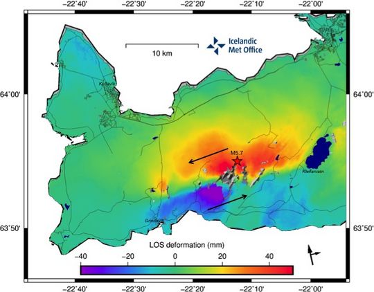
Red amplitudes represent movement towards the satellite and purple
amplitudes movement away from the satellite (path is west of Iceland). The
black arrows in the right corner below show the heading and look direction of
the satellite. The magnitude 5.7 earthquake that occurred on the 24th February
is displayed by the red star. Here is a PDF version of the picture above.
There is no indication in this interferogram for shallow magmatic intrusions, however the inflow of magma from depth cannot be ruled out, as this activity is part of an ongoing volcano-tectonic reactivation of the ReykjanesPeninsula.


