
Increased electrical conductivity and gas pollution at Múlakvísl
Updated 1 September
Electrical conductivity in Múlakvísl has remained high for this time of year over the past few days. Values have ranged between 250 and 270 μS/cm since 30 August. Electrical conductivity measurements indicate the amount of geothermal water present in rivers, and high values suggest an ongoing discharge of geothermal water, similar to that observed on 19 August. The river level has not risen alongside the increased conductivity, although a rise cannot be ruled out in the coming hours. Glacial outburst floods of this magnitude are well known in Múlakvísl.
This geothermal discharge is currently accompanied by significant gas pollution. The Icelandic Meteorological Office operates a gas monitor at Láguhvolar, approximately 2 km from the margin of Kötlujökull glacier. An increase in hydrogen sulphide (H₂S) was detected overnight, and concentrations are now above health protection limits. People are therefore advised not to remain near the river or its source at the glacier margin.
Winds in the area are light or calm, allowing gas to accumulate in depressions in the terrain. This may pose a serious hazard to travellers in the area. Anyone experiencing symptoms such as irritation of the nose or eyes should leave the area immediately.
The Icelandic Meteorological Office's 24-hour monitoring team continues to monitor measurements in the area and will issue further information if conditions change.
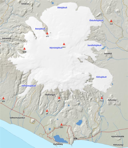
The map shows the locations of the webcam and the electrical conductivity meter.
Updated 20 August
Glacial outburst flood in Múlakvísl appears to be subsiding
The glacial outburst flood in Múlakvísl, which began on 18 August, now
appears to be subsiding. Both conductivity and discharge have decreased
since yesterday, and currently there is no gas pollution being detected
in the area. However, it is still too early to say whether the event has
ended. Travelers are still urged to exercise caution and to leave the
area if they notice symptoms that could indicate gas pollution. The
Icelandic Meteorological Office will continue to monitor the area
closely and provide updates as needed.
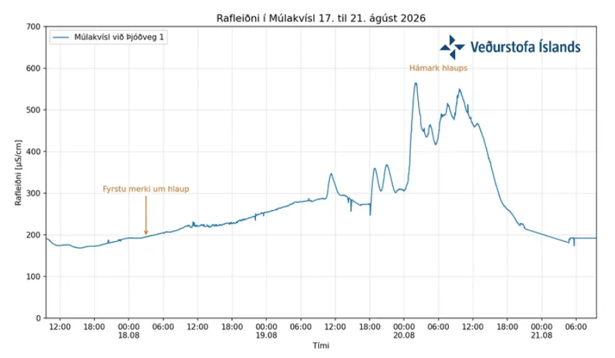 The graph shows conductivity measurements in Múlakvísl at Route 1 (Þjóðvegur 1) from 17 August until this morning, 21 August.
The water level in the river did not rise significantly, but the river spread out across its channel, indicating that discharge had increased. The Icelandic Meteorological Office's webcameras near Múlakvísl show this in the following images.
The image on the left shows Múlakvísl at Láguhvolar, and on the right at Route 1 (Þjóðvegur 1), from 18–21 August.
Updated 20 August
Increased discharge and significant gas pollution in Múlakvísl
The glacial outburst flood that began in Múlakvísl on 18 August is ongoing. Since yesterday, electrical conductivity and discharge in the river have increased, and gas pollution continues to be detected in the area. Yesterday evening, electrical conductivity rose fairly sharply and now measures just over 500 µS/cm, which is unusually high compared with recent glacial outburst floods in the river. Conductivity last reached a similar level during the glacial outburst flood in July 2017, when it peaked at 580 µS/cm.
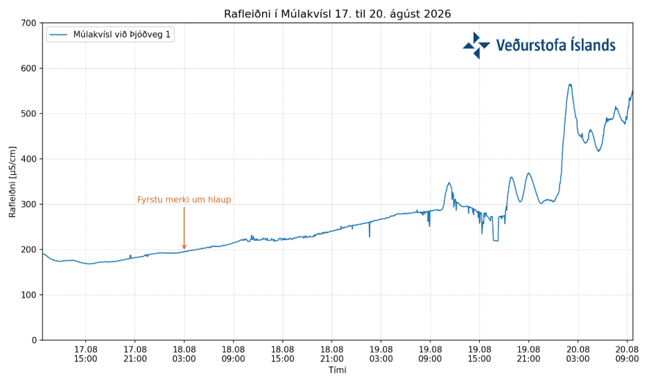
Electrical conductivity measurements in Múlakvísl at Route 1 from 17 August until the morning of 20 August.
So far, the water level in the river has not risen significantly. However, webcam footage shows that the river has spread across a wider area, indicating that discharge has increased.
Several geothermal areas are known to exist beneath Mýrdalsjökull. Meltwater drains continuously from these areas, and the local topography determines whether or not it accumulates. The amount of water that collects in these subglacial lakes before an outburst occurs varies, as does the rate at which they drain.
Glacial outburst floods of this magnitude are well known in Múlakvísl. This event is accompanied by significant gas pollution. People are therefore advised not to remain near the river or close to where it emerges at the glacier margin. The calm weather in recent days also increases the risk of gas accumulating in depressions. Anyone experiencing symptoms such as irritation of the nose or eyes should leave the area immediately.
The Icelandic Meteorological Office is closely monitoring developments and remains in direct contact with Civil Protection.
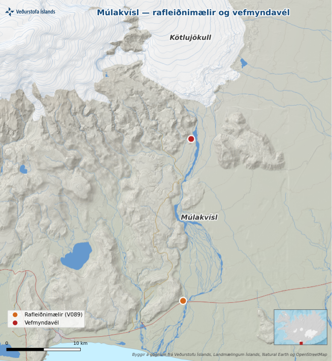
The map shows the locations of the webcam and the electrical conductivity meter.
News from 19 August
Minor glacial outburst flood in Múlakvísl
Over the past few days, electrical conductivity in the Múlakvísl river has risen steadily and is now unusually high for this time of year, measuring approximately 285 µS/cm. Conductivity measurements indicate the amount of geothermal water in rivers, and high values suggest that a minor glacial outburst flood is under way. So far, the river's water level has not risen in line with the increase in conductivity, but it may do so over the coming days.
Glacial outburst floods of this magnitude are well known in Múlakvísl. This event is accompanied by significant gas pollution. The Icelandic Meteorological Office operates a gas monitor at Láguhvolar, approximately 2 km from the margin of Kötlujökull glacier. Overnight, concentrations of hydrogen sulphide (H₂S) exceeded the health protection limit at the site. People are therefore advised not to remain near the river or its source at the glacier margin. The calm weather in recent days also increases the risk of gas accumulating in depressions. Anyone experiencing symptoms such as irritation of the nose or eyes should leave the area immediately.
The Icelandic Meteorological Office's 24-hour monitoring team continues to monitor measurements in the area and will issue further information if conditions change.
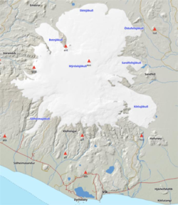
The orange triangles indicate IMO seismic stations around Mýrdalsjökull. The gas monitor at Láguhvolar is located south of Kötlujökull, at the same site as the seismic station marked Hvo on the map.


