Renewed movement detected at Svínafellsheiði
The landslide monitoring system at Svínafellsheiði, above the eastern part of Svínafellsjökull glacier, has detected movement since 23 September. This is the first movement to be detected so clearly since monitoring began in autumn 2018. Measured deformation since 23 September amounts to approximately one to three centimetres and has been confirmed by different monitoring instruments, including GPS stations and extensometers. Experts from the Icelandic Meteorological Office and the University of Iceland consider the measurements to indicate that the slope has begun moving again, and the Icelandic Meteorological Office has increased monitoring. A field visit is planned in the coming days to examine conditions and verify the measurement results.
No displacement has been detected at other GPS stations on or near Öræfajökull, strongly suggesting that the movement is localised to Svínafellsheiði. No indications have emerged of any connection to changes in the volcano.
What do the measurements mean?
The movement is slow and does not, in itself, indicate an imminent risk of a rock avalanche. Changes in the rate of movement of large unstable slopes are not uncommon, and at this stage it is not possible to predict with certainty how the situation will develop. It is therefore too early to assess whether the movement will increase, remain at a similar level or subside.
Based on the available data, there is currently not considered to be an imminent risk of a rock avalanche. However, this assessment could change if further changes occur in the measured movement or in other factors affecting the stability of the area.
In the assessment of experts, the movement detected so far does not call for any special response measures at this stage beyond increased monitoring, analysis and follow-up by the Icelandic Meteorological Office and the University of Iceland. This conclusion was reached in consultation with the Department of Civil Protection and Emergency Management and the South Iceland Police.
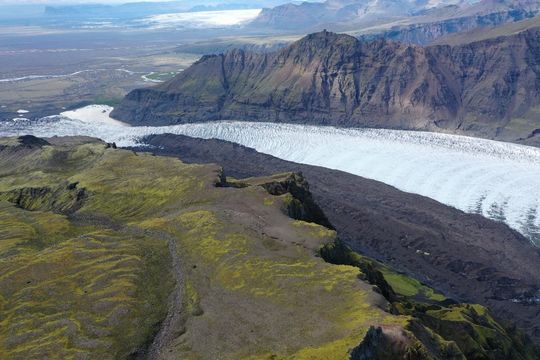
An aerial photograph of Svínafellsjökull glacier and Svínafellsheiði. The unstable slope, which is now being monitored following recent movement, can be seen above the glacier. In 2013, a large landslide fell from the slope onto the glacier, and the landslide debris remains visible as a dark band on its surface.
Why is the area monitored?
A fracture system approximately 1.7 kilometres long extends across the mountainside. It is thought to have formed around 15 to 20 years ago. Satellite data and direct measurements showed deformation of the slope between 2015 and 2017, after which the movement slowed considerably.
However, the full extent of the fracture system did not become clear until 2018, prompting the installation of a monitoring system in the area. Since then, movement has been very limited, with total displacement recorded by continuously operating instruments remaining below one centimetre until this autumn.
According to the Icelandic Meteorological Office's 2025 hazard assessment (in Icelandic), the most likely scenario is that a rock avalanche from the slope onto the glacier would stop on the glacier without reaching the lagoon in front of the glacier terminus and would therefore not threaten populated areas.
However, it cannot be ruled out that a very large rock avalanche could reach the glacier margin and potentially enter the lagoon, causing flooding.
The hazard assessment is based on numerical modelling carried out between 2018 and 2020. It is now being considered whether the assessment needs to be revised in light of new data.
What could explain the movement?
The cause of the renewed movement has not been established. One possible explanation is increased water pressure within the mountain.
Precipitation at Skaftafell has been above average since August, although not unusually high compared with previous years. However, approximately 100 millimetres of precipitation was recorded over a 24-hour period in early October, followed later by another rainfall event of around 95 millimetres. The extensometers began registering movement around the same time.
All precipitation gauges are located at low elevations, so it is uncertain how much precipitation fell higher up on the mountain.
Over recent decades, glaciers in Iceland have been retreating and thinning, affecting the stability of the slopes above them.
Glacial retreat at Svínafellsjökull has largely followed the same pattern as elsewhere on the glacier, with the exception of the area directly below the unstable slope.
In 2013, a large landslide fell onto the glacier, covering a substantial part of its surface below the slope. The landslide debris has an insulating effect on the glacier ice, significantly reducing melting beneath it.
As a result, the ice beneath the landslide debris has been better preserved than the ice in surrounding areas, leaving a thicker mass of ice. This ice mass may have provided additional support to the slope, thereby contributing to its stability.
However, this mass of ice is now moving down-glacier and gradually away from the foot of the slope. As the ice retreats, the support it provides to the slope decreases, which could explain the movement now being detected in the area.
It is possible that a combination of all these factors has contributed to the renewed deformation.
Next steps
Experts from the Icelandic Meteorological Office and the University of Iceland are closely monitoring developments and conducting further analysis of the data. Monitoring data are now being reviewed more frequently, including during the night. Research at Svínafellsheiði is a collaborative project between the Icelandic Meteorological Office and the University of Iceland.
A field visit is planned as soon as conditions allow, to survey fixed measurement points, capture drone imagery and inspect the monitoring equipment. The possibility of installing an additional GPS station is also being considered to provide a better overview of the movement.
The Icelandic Meteorological Office has informed the civil protection authorities of the situation and is consulting with them on the next steps and the provision of information to local residents.