
Ash plume and lightnings
Flash flood unlikely
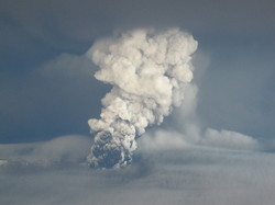
The eruption in Grímsvötn began after 17:30 on Saturday May 21st (see photos). The altitude of the plume is monitored by two weather radars, one located in Keflavík International Airport 220 km from the volcano, and a mobile one currently situated approx. 80 km away from the volcano. For further information, see Update.
Initially the plume reached approx. 20 km altitude but during the night it fell to 15 km, occasionally rising to 20 km. During the morning of the 22nd the plume was lower still, or at around 10 km in altitude, rising occasionally to 15 km.
Lightning is monitored using the British Met. Office lightning detection system. Lighthing activity follows a similar pattern as the plume altitude with intermittent periods of strong lightning activity. During the most intense lightning period the number of lightnings per hour were 1000 times more than during the Eyjafjallajokull Eruption.
The Grímsvötn volcano is Iceland‘s most active volcano. It last erupted in 2004 and the current eruption is in a similar location. Flash floods south of the volcano often occur associated with eruptions, but can also happen in between eruptions. The latest such flood occurred in October 2010, so a big flood currently appears unlikely.
The MODIS satellite picture taken around 5 o'clock this morning shows the plume; at sunrise the plume casts a dark shadow to the west:

For flight traffic concern, please consult London VAAC, the Volcanic Ash Advisory Centre.


