
SeisComP becomes the new primary earthquake monitoring system of the Icelandic Meteorological Office
- As of today, SeisComP has formally become the primary system of the Icelandic Meteorological Office (IMO) for earthquake monitoring and analysis.
- The SIL system, which has been in operation since 1991, is now being replaced by a more modern and flexible system after more than three decades of service.
- SeisComP significantly strengthens the IMO's ability to monitor seismic activity in real time and supports reliable and efficient communication of information related to natural hazards.
- SIL will continue to operate as a secondary system while SeisComP is being fine-tuned and historical data are transferred, ensuring continuity in earthquake records.
- An updated version of Skjálftalísa has replaced the previous version, and a new data gateway enables users to more easily access and work with earthquake data.
Today, the Icelandic Meteorological Office formally commissioned SeisComP as its primary system for earthquake monitoring and analysis. This marks the end of decades of reliance on the SIL system, which has been a cornerstone of earthquake monitoring in Iceland since the introduction of digital, automated seismic measurements and analysis in 1991. At the time of its development, SIL was highly innovative and a pioneer in the field, particularly in terms of automation and the use of neural networks. Data harmonisation will be carried out retroactively to 1 February.
A major step forward in earthquake monitoring
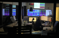
The implementation of SeisComP represents a major step forward in the development of the IMO's earthquake monitoring capabilities. Preparations have been underway for several years, and the system transition involves both technical and procedural changes aimed at improving analytical capability, data dissemination, and providing a more modern working environment for specialists.
“With SeisComP, we are strengthening the Icelandic Meteorological Office's capacity to detect and assess seismic activity in real time. Such developments are vital for public safety and for the reliable communication of information on natural hazards.”
Kristín Jónsdóttir,
Head of the Department of Earth Sciences (volcanology, seismology and crustal
deformation), Service and Research Division, Icelandic Meteorological Office
New Skjálftalísa and improved data access
In connection with the system transition, the Skjálftalísa web interface has been upgraded. The new version offers a wide range of layers and new analytical tools.
Work is currently underway to transfer the historical SIL earthquake catalogue into SeisComP, and Skjálftalísa will be updated accordingly. At the same time, a new data gateway (Quakes API) is being introduced, enabling users to access and work with earthquake data more efficiently.

The new Skjálftalísa of the Icelandic Meteorological Office, based on data from the SeisComP system, displays seismic activity on a map along with analyses of earthquake depth, frequency, and temporal evolution.
What can users expect?
- The number of reviewed earthquakes may initially be lower while manual analysis reaches the same pace as before.
- Earthquake locations may change slightly due to differences in processing methods between the systems.
- SeisComP has been tuned to detect small earthquakes and may be more sensitive in certain regions.
- The new Skjálftalísa has now been launched.
SeisComP – a new system built on a solid foundation
SeisComP is the most widely used earthquake monitoring system in the world. The Icelandic Meteorological Office's partners, including ÍSOR, the Swedish National Seismic Network (SNSN), and the Swiss Seismological Service (SED), use SeisComP in their operations and have supported the IMO during the implementation process.
SeisComP is an open-source system (AGPL). Development and maintenance are carried out in collaboration with the software company Gempa, which also offers licensed extensions and services. One of SeisComP's key strengths is the ease with which custom processing methods can be integrated directly into the system. In recent years, the IMO has been fine-tuning specialised software modules to meet the sensitivity requirements of Iceland's active seismic regions. The system is fully integrated, covering the entire workflow from data acquisition and distribution to quality control and real-time analysis.
The history of SIL – a system that shaped earthquake research in Iceland
The SIL earthquake monitoring system was commissioned in 1991, coinciding with the introduction of digital and automated seismic measurements in Iceland. The system was designed to automatically detect micro-earthquakes down to magnitude M0, providing sufficiently detailed data for research into earthquake forecasting and stress accumulation in the Earth's crust.
The development of SIL involved seismologists from across the Nordic countries, led by Ragnar Stefánsson, including Reynir Böðvarsson of Uppsala University and Ragnar Slunga of the Swedish Defence Research Agency (FOI). The system was designed for the South Iceland Seismic Zone, also known as the South Iceland Lowland, from which it derives its name (South Iceland Lowland / Södra Islands Lågland).
To achieve its objectives, a dense network of seismic stations was established, and processing methods were developed to detect very weak micro-seismic signals despite high environmental noise levels. The project was highly successful, and for a time the SIL system ranked among the world's leading systems for micro-earthquake detection and analysis.
The first eight seismic stations were installed in South Iceland in 1989–1990, and automated processing began in late May 1991. Since then, the network has expanded significantly and now monitors Iceland's plate boundaries as well as its volcanic systems. The network currently consists of approximately 100 stations.
In the early years of operation, between two and three thousand earthquakes were recorded annually. As the network expanded, its sensitivity increased substantially, and the number of detected earthquakes has grown accordingly, particularly during seismic swarms, magma intrusions, and volcanic eruptions. In total, the SIL system has automatically detected more than 1.1 million earthquakes, of which approximately 780,000 have been reviewed by specialists at the Icelandic Meteorological Office.

Example of earthquake recording in the SIL system, showing manual picking of P- and S-waves. The system was commissioned in 1991 and has been a cornerstone of earthquake monitoring in Iceland for more than three decades but is now being replaced by SeisComP.
Further development ahead
The implementation of SeisComP marks the beginning of the second phase of the project. In the coming months, continued work will focus on improving analytical capability, earthquake locations, documentation, and the system's user interface.
The Icelandic Meteorological Office thanks all those who have contributed


