Update on the weather forecast and flood conditions
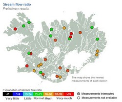
Stream and river levels remain high
The south
Following continued, heavy rainfall overnight, stream and river levels remain high in south of the country.
The west
Rivers in the west, such as Hvítá at Kljáfoss and Vatnsdalsá, peaked earlier today, although further rain is expected in the region this afternoon.
The southern glaciers
Streams and rivers around Eyjafjallajökull, Mýrdalsjökull, and southern parts of Vatnajökull are very high, including Krossá, Jökulsá á Sólheimasandi, Múlakvísl, and Djúpá. Further heavy rainfall is forecast for this region today, so river levels will increase further until late on Thursday evening.
Southern inland
Hvítá í Árnessýslu continues to rise in response to heavy rainfall during the past two days. All tributaries to Hvítá are high, including Sog. In Selfoss, the discharge of Ölfusá is presently 650 m3 / s and the flow is expected to increase until late on Friday or early on Saturday. It is likely that the flood peak in Ölfusá will be over 1,000 m3 /s, which last occurred in February 2013.
Reykjavík area
Streams and rivers in the capital region are also in flood, including Elliðaá and Korpa. River levels in this region will decrease later today.


