
Gasmengun
Volcanic gases
Gas pollution forecast, distribution model and registration form for gas pollution.
Below is a text forecast regarding gas pollution from the eruption in Fagradalsfjall. At the bottom of the page is a forecast model showing sulfur pollution (SO2) in inhabited areas for the next 48 hours.
The first map shows the level of pollution at ground level. The other three maps shows an impact forecast for the next 6hrs and 24hrs. These maps indicate areas, not level of pollution.
Important information about gas pollution for people in the volcanic hazard zone:
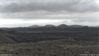
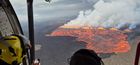
- Gas pollution can always reach unhealthy levels near the eruption zone. The gas plume is advected down wind.
- In calm wind conditions (< 5 m/s) the distribution of gas pollution can become unpredictable, as the heat from the lava field can affect wind direction in the area.
- The lava field also produces gas pollution because of degasification.
- If you experience symptoms it is important to leave the polluted area.


