
- Orange alert for weather: South Iceland, Faxafloi - Southwest Iceland, Southeast Iceland and Central highlands - Uninhabited part of Iceland More
- Yellow alert for weather: Reykjavik - Capital Region, South Iceland, Faxafloi - Southwest Iceland, Breidafjordur - Westnorthwest Iceland, Westfjords, Northwest Iceland, Northeast Iceland, East Iceland, Eastfjords and Southeast Iceland More
Home-page - Icelandic Meteorological Office
Weather forecast
Weather forecast for the next 24 hours
Northeast 8-13 m/s and snowshowers, but lighter winds and mainly fair in the southwest. Day time temperatures of around freezing, but sub zero temperatures during night time.
Increasing easterly wind tomorrow, 20-28 m/s with snow and blowing snow around noon, first and strongest wind in the far south. Windgusts can excess more than 40 m/s around mountains. Much lighter winds and dry in the north until in the afternoon. Turning into rain or sleet in the south in the evening and becoming warmer.
Forecast made 05.04.2026 13:31
Forecaster's remarks
Becoming easterly blizzard on tomorrow, Monday. Please check latest weather warnings.
Prepared by the meteorologist on duty 05.04.2026 13:31
If the map and the text forecast differs, then the text forecast applies
Forecast for station - 1
Forecast for station - 2
Forecast for station - 3
Forecast for station - 4
Forecast for station - 5
Maximum wind in Iceland today
| Lowlands | |
|---|---|
| Highlands | |
|---|---|
Maximum and minimum temperature in Iceland today
| Lowlands | |
|---|---|
| Highlands | |
|---|---|
Maximum precipitation in Iceland today
| Lowlands | |
|---|---|
| Highlands | |
|---|---|
Maximum wind in Iceland during the last hour
| Lowlands | |
|---|---|
| Highlands | |
|---|---|
Maximum and minimum temperature in Iceland during the last hour
| Lowlands | |
|---|---|
| Highlands | |
|---|---|
Maximum precipitation in Iceland during the last hour
| Lowlands | |
|---|---|
| Highlands | |
|---|---|
Preliminary results
Earthquakes
Earthquakes during last 48 hours. at 05 Apr 14:00 GMT
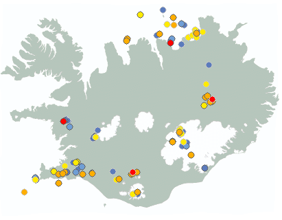

Biggest earthquakes during the last 48 hours
| Size | Time | Quality | Location |
|---|---|---|---|
| 2.0 | 04 Apr 20:00:59 | 50.0 | 43.7 km W of Grímsey |
| 1.8 | 05 Apr 02:46:20 | Checked | 26.1 km ENE of Hraun á Skaga |
| 1.7 | 04 Apr 07:46:01 | Checked | 120.9 km ENE of Kolbeinsey |
| 1.6 | 05 Apr 06:54:13 | Checked | 11.4 km NNW of Álftavatn |
| 1.4 | 03 Apr 16:37:10 | 50.0 | 5.2 km SE of Flatey |
| 1.3 | 03 Apr 16:48:36 | 50.0 | 12.0 km ESE of Húsafell |
Week overview -
Earthquake activity throughout the country is described in a weekly summary that is written by a Natural Hazard Specialist. The weekly summary is published on the web every Tuesday. It covers the activity of the previous week in all seismic areas and volcanic systems in the country. If earthquake swarms are ongoing or significant events such as larger earthquakes have occurred during the week, they are specifically discussed. More
Hydrology
Average flow and temperature last 24 hours
| River | Place | Flow | Water temperature |
|---|
Remarks of a specialist
Due to malfunction we have turned off the service publishing hydrological data on the map. Instead see the data using our Real-time monitoring system.
Written by a specialist at 23 Mar 16:00 GMT
Avalanche forecasts are now published on Icelandic Met Office’s new website:
New avalanche pages on gottvedur.is/en
News from the Icelandic Met Office’s landslide monitoring service will continue to be published on vedur.is (in Icelandic)
News
Magma volume beneath Svartsengi has never been greater since the start of the eruption sequence

Nordic report on the impacts of a AMOC tipping urges stronger mitigation, monitoring and preparedness
The report A Nordic Perspective on AMOC Tipping reviews the current state of science on the impacts of potential Atlantic Meridional Overturning Circulation (AMOC) collapse and provides recommendations for policy actions.
Read moreThe weather in Iceland in 2025
The year 2025 was the warmest year in Iceland since measurements began. The national average temperature was 5.2 °C, which is 1.1 °C above the average for the years 1991–2020 and the highest ever recorded. Temperatures were well above average for almost every month of the year. The spring weather was exceptionally favourable; it was the warmest spring ever recorded nationwide, and May was by far the warmest May on record. In mid-May, a 10-day heatwave occurred across the entire country. It was the most significant heatwave known in Iceland for the month of May. Overall, the weather in 2025 was unusually calm, with few stormy days and generally favourable conditions. It was relatively wet at the beginning of the year but dry toward the end. Snow cover was light across the entire country.
Read more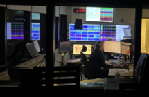
SeisComP becomes the new primary earthquake monitoring system of the Icelandic Meteorological Office
The implementation of SeisComP represents a major step forward in the development of the IMO's earthquake monitoring capabilities. Preparations have been underway for several years, and the system transition involves both technical and procedural changes aimed at improving analytical capability, data dissemination, and providing a more modern working environment for specialists.
Read more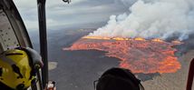
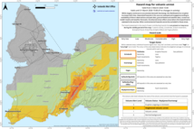
The ninth eruption on the Sundhnúkur crater row has ended
Updated 5 August
The volcanic eruption that began on 16 July on the Sundhnúkur crater row is now officially over, and a new hazard map has been issued. Despite the end of the eruption, life-threatening conditions remain in the area due to unstable lava and the potential for gas pollution. Uplift has resumed, and magma continues to accumulate beneath Svartsengi.
Read moreHeavy thunder and lightning in Northwest Iceland and the Westfjords
By 11:00, more than 450 lightning strikes had been recorded since the activity began.
Read moreShort articles
Past temperature conditions in Iceland
This has been a period of a general rise in temperatures, interrupted by two cold periods. The late 19th century cold period was colder than a corresponding period in mid to late 20th century.
Read moreNew publications and research
- Guðrún Nína Petersen (2025). Alviðruhamrar - Meteorological conditions
- Michelle Parks, Freysteinn Sigmundsson, Vincent Drouin, Ásta R. Hjartardóttir, Halldór Geirsson, Andrew Hooper, Kristín S. Vogfjörð, Benedikt G. Ófeigsson, Sigrún Hreinsdóttir, Esther H. Jensen, Páll Einarsson, Sara Barsotti & Hildur M. Friðriksdóttir. (2023).
- Sahar Rahpeyma, Benedikt Halldórsson, Birgir Hrafnkelsson & Atefe Darzi. (2023). Frequency-dependent site amplification functions for key geological units in Iceland from a Bayesian hierarchical model for earthquake strong-motions.
- Sara Klaasen, Solvi Thrastarson, Yesim Cubuk-Sabuncu, Kristín Jónsdóttir, Lars Gebraad, Patrick Paitz & Andreas Fichtner. Subclacial volvano monitoring with fiber-optic sensing: Grímsvötn, Iceland. (2023).
- Ismael Vera Rodriquez, Marius P. Isken, Torsten Dahm, Oliver D. Lamb, Sin-Mei Wu, Sigríður Kristjánsdóttir, Kristín Jónsdóttir, Pilar Sanchez-Pastor, John Clinton, Christopher Wollin, Alan F. Baird, Andreas Wuestefeld, Beat Booz, Eva P.S.Eibl, Sebastian Heimann, Bettina P. Goertz-Allmann, Philippe Jousset, Volker Qye, Vala Hjörleifsdóttir, Anne Obermann. (2002).
- Lamb, O.D., Gestrich, J.E., Barnie, T.D., Jónsdóttir, K., Ducrocq, C., Shore, M.J., Lees, J.M., Lee, S.J (2022). Acoustic observations of lava fountain activity during the 2021 Fagradalsfjall eruption, Iceland. Bull Volcanol 84, 96. doi.org/10.1007/s00445-022-01602-3
- Freysteinn Sigmundsson, Michelle Parks, Andrew Hooper, Halldór Geirsson, Kristín S. Vogfjörd, Vincent Drouin, Benedikt G. Ófeigsson, Sigrún Hreinsdóttir, Sigurlaug Hjaltadóttir, Kristín Jónsdóttir, Páll Einarsson, Sara Barsotti, Josef Horálek & Thorbjörg Ágústsdóttir (2022). Deformation and seismicity decline before the 2021 Fagradalsfjall eruption. Nature 609, 523–528. doi.org/10.1038/s41586-022-05083-4
Search
Contact IMO
© Veðurstofa Íslands | Bústaðavegi 7- 9 | 105 Reykjavík | Phone 522 6000 | Fax: 522 6001
Recording 902 0600 | SSN 630908-0350
Contact us | Employees | Terms and conditions | Sitemap


