
Home-page - Icelandic Meteorological Office
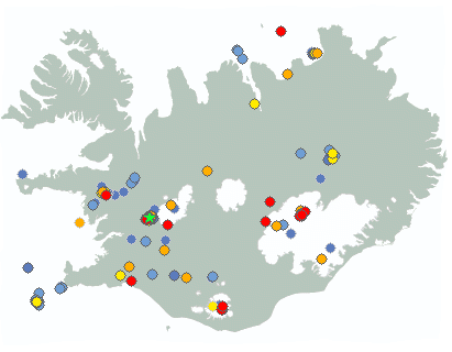
Weather forecast
Weather forecast for the next 24 hours
Westerly or variable wind 3-8 m/s, partly cloudy and some patches of rain. Temperature 8 to 15 deg. C.
Becoming southwesterly 5-13 m/s tomorrow. Rain or rainshowers and temperature 7 to 13 deg. C, but dry in East-Iceland until afternoon with temperature up to 18 deg. C.
Forecast made 24.06.2026 15:12
If the map and the text forecast differs, then the text forecast applies
Forecast for station - 1
Forecast for station - 2
Forecast for station - 3
Forecast for station - 4
Forecast for station - 5
Maximum wind in Iceland today
| Lowlands | |
|---|---|
| Highlands | |
|---|---|
Maximum and minimum temperature in Iceland today
| Lowlands | |
|---|---|
| Highlands | |
|---|---|
Maximum precipitation in Iceland today
| Lowlands | |
|---|---|
| Highlands | |
|---|---|
Maximum wind in Iceland during the last hour
| Lowlands | |
|---|---|
| Highlands | |
|---|---|
Maximum and minimum temperature in Iceland during the last hour
| Lowlands | |
|---|---|
| Highlands | |
|---|---|
Maximum precipitation in Iceland during the last hour
| Lowlands | |
|---|---|
| Highlands | |
|---|---|
Preliminary results
Earthquakes
Earthquakes during last 48 hours. at 24 Jun 15:20 GMT

Biggest earthquakes during the last 48 hours
| Size | Time | Quality | Location |
|---|---|---|---|
| 3.3 | 24 Jun 00:07:55 | Checked | 14.6 km SSE of Húsafell |
| 2.2 | 24 Jun 01:04:24 | Checked | 14.4 km SSE of Húsafell |
| 2.1 | 24 Jun 00:49:49 | Checked | 14.2 km SSE of Húsafell |
Specialist remark
An earthquake of magnitude 3.3 was measured just NW of Þórisjökull at 00:07 this night. About 30 earthquakes have been detected following the bigger earthquake. On June 3rd, two earthquakes of magnitude 3.9 and 3.3 occurred in this area. Seismic activity began to increase in early May of this year.
Written by a specialist at 24 Jun 05:53 GMT
Week overview -
Earthquake activity throughout the country is described in a weekly summary that is written by a Natural Hazard Specialist. The weekly summary is published on the web every Tuesday. It covers the activity of the previous week in all seismic areas and volcanic systems in the country. If earthquake swarms are ongoing or significant events such as larger earthquakes have occurred during the week, they are specifically discussed. More
Hydrology
Average flow and temperature last 24 hours
| River | Place | Flow | Water temperature |
|---|
Remarks of a specialist
Due to malfunction we have turned off the service publishing hydrological data on the map. Instead see the data using our Rauntímavöktunarkerfi.
Written by a specialist at 30 Apr 13:37 GMT
Avalanche forecasts are now published on Icelandic Met Office’s new website:
New avalanche pages on gottvedur.is/en
News from the Icelandic Met Office’s landslide monitoring service will continue to be published on vedur.is (in Icelandic)
News
Ground uplift and magma accumulation continue beneath Svartsengi
The Icelandic Met Office receives international grant to strengthen aviation safety in relation to volcanic hazards
In October 2025, the Icelandic Meteorological Office (IMO) received a grant of ISK 147 million from the International Civil Aviation Organization (ICAO) for four new development projects in the fields of volcanic hazards and aviation safety. The projects involve, among other things, the development of new measurement methods, automatic analysis of eruption plumes, coordination of responses among European volcano observatories, and research into the effects of sulphur dioxide (SO₂) on aviation.
Read more
IMO expert to lead international collaboration on geohazards

Nordic report on the impacts of a AMOC tipping urges stronger mitigation, monitoring and preparedness
The report A Nordic Perspective on AMOC Tipping reviews the current state of science on the impacts of potential Atlantic Meridional Overturning Circulation (AMOC) collapse and provides recommendations for policy actions.
Read moreThe weather in Iceland in 2025
The year 2025 was the warmest year in Iceland since measurements began. The national average temperature was 5.2 °C, which is 1.1 °C above the average for the years 1991–2020 and the highest ever recorded. Temperatures were well above average for almost every month of the year. The spring weather was exceptionally favourable; it was the warmest spring ever recorded nationwide, and May was by far the warmest May on record. In mid-May, a 10-day heatwave occurred across the entire country. It was the most significant heatwave known in Iceland for the month of May. Overall, the weather in 2025 was unusually calm, with few stormy days and generally favourable conditions. It was relatively wet at the beginning of the year but dry toward the end. Snow cover was light across the entire country.
Read more
SeisComP becomes the new primary earthquake monitoring system of the Icelandic Meteorological Office
The implementation of SeisComP represents a major step forward in the development of the IMO's earthquake monitoring capabilities. Preparations have been underway for several years, and the system transition involves both technical and procedural changes aimed at improving analytical capability, data dissemination, and providing a more modern working environment for specialists.
Read moreShort articles

Climatological data
Through links in this article, climatological information is available, i.e. monthly- and annual values of various weather components in Iceland since 1961. Averages provided are either monthly or annual averages. Temperature is given in degrees celsius, air pressure in hPa, humidity in percentages, precipitation in millimeters and windspeed in m/s.
Read moreNew publications and research
- Guðrún Nína Petersen (2025). Alviðruhamrar - Meteorological conditions
- Michelle Parks, Freysteinn Sigmundsson, Vincent Drouin, Ásta R. Hjartardóttir, Halldór Geirsson, Andrew Hooper, Kristín S. Vogfjörð, Benedikt G. Ófeigsson, Sigrún Hreinsdóttir, Esther H. Jensen, Páll Einarsson, Sara Barsotti & Hildur M. Friðriksdóttir. (2023).
- Sahar Rahpeyma, Benedikt Halldórsson, Birgir Hrafnkelsson & Atefe Darzi. (2023). Frequency-dependent site amplification functions for key geological units in Iceland from a Bayesian hierarchical model for earthquake strong-motions.
- Sara Klaasen, Solvi Thrastarson, Yesim Cubuk-Sabuncu, Kristín Jónsdóttir, Lars Gebraad, Patrick Paitz & Andreas Fichtner. Subclacial volvano monitoring with fiber-optic sensing: Grímsvötn, Iceland. (2023).
- Ismael Vera Rodriquez, Marius P. Isken, Torsten Dahm, Oliver D. Lamb, Sin-Mei Wu, Sigríður Kristjánsdóttir, Kristín Jónsdóttir, Pilar Sanchez-Pastor, John Clinton, Christopher Wollin, Alan F. Baird, Andreas Wuestefeld, Beat Booz, Eva P.S.Eibl, Sebastian Heimann, Bettina P. Goertz-Allmann, Philippe Jousset, Volker Qye, Vala Hjörleifsdóttir, Anne Obermann. (2002).
- Lamb, O.D., Gestrich, J.E., Barnie, T.D., Jónsdóttir, K., Ducrocq, C., Shore, M.J., Lees, J.M., Lee, S.J (2022). Acoustic observations of lava fountain activity during the 2021 Fagradalsfjall eruption, Iceland. Bull Volcanol 84, 96. doi.org/10.1007/s00445-022-01602-3
- Freysteinn Sigmundsson, Michelle Parks, Andrew Hooper, Halldór Geirsson, Kristín S. Vogfjörd, Vincent Drouin, Benedikt G. Ófeigsson, Sigrún Hreinsdóttir, Sigurlaug Hjaltadóttir, Kristín Jónsdóttir, Páll Einarsson, Sara Barsotti, Josef Horálek & Thorbjörg Ágústsdóttir (2022). Deformation and seismicity decline before the 2021 Fagradalsfjall eruption. Nature 609, 523–528. doi.org/10.1038/s41586-022-05083-4
Search
Contact IMO
© Veðurstofa Íslands | Bústaðavegi 7- 9 | 105 Reykjavík | Phone 522 6000 | Fax: 522 6001
Recording 902 0600 | SSN 630908-0350
Contact us | Employees | Terms and conditions | Sitemap


