
Weather warning - high winds and rain expected
Forecast for Tuesday and Wednesday
Tomorrow, Tuesday, a rather deep low is forecasted in the southwest and west of Iceland.
Southeast winds, 10-18 m/s are expected in the southwest and west with wind gusts up to 35 m/s. Heavy rain is expected, with the greatest amounts in the South tomorrow afternoon and evening.
On Wednesday the low is forecasted to move to the northeast over Iceland. Winds turn to northwest and west winds, 10-20 m/s, with the highest winds in the nortwest part. Precipitation will continue, with the highest accumulation in the nortwest and northern parts of the country.
Winds are expected to moderate on Thursday, but the precipitation is not expected to decrease in the north.
Water levels are expected to rise over the next few days (see Hydrology). Travelers are encouraged to monitor the weather closely, both forecasts and observations, over the next few days. Updated forecasts for wind and precipitation are given but the text forecasts are most reliable.
Forecasters on duty: Elín Björk Jónasdóttir and Haraldur Eiríksson
Warning due to flooding
Rising stream and river levels are expected on the Snæfellsnes peninsula, the Hvítá region (both west and south of Langjökull), around the Eyjafjallajökull and Mýrdalsjökull ice caps, and south of the Vatnajökull ice cap. Travellers are cautioned against fording rivers in these regions. Mudflows (lahars) could occur on the southern slopes of Eyjafjallajökull, for example on the Svaðbælisá river.
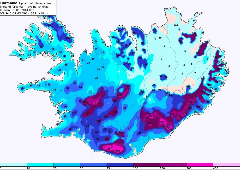
Heavy rainfall is forecast for west, south-west, south, and south-east Iceland, beginning late on Monday and lasting throughout Wednesday. In these regions, the heaviest rainfall is expected around mountains and ice caps. Cumulative rainfall amounts could exceed 150 mm over 24 hours and heavy melting of snow and ice is expected (see map).

Cumulative run-off (in millimetres) due to rainfall and meltwater from 07:00 on Monday 30 June to 06:00 on Wednesday 2 July 2014. Note that this forecast only covers 48 hours and rainfall and melting will continue on Wednesday. Click to enlarge.
According to the latest meteorological forecasts, the approaching low will produce enough rainfall to cause localised flooding. This must be taken into account when making travel plans. Travellers are strongly cautioned against fording rivers in the above mentioned regions.
Hydrologists on duty: Þorsteinn Þorsteinsson and Matthew J. Roberts


