Ground uplift and magma accumulation continue beneath Svartsengi
Updated 9 June 2026
- Uplift at Svartsengi continues at a steady rate
- Around 27.5 million cubic metres of magma have accumulated since around mid-July last year
- Seismic activity remains low
- The hazard assessment remains unchanged and is valid until 30 June
Deformation
Uplift and magma accumulation continue at Svartsengi, and the trend remains
stable. The latest model calculations indicate that around 27.5 million cubic
metres of magma have accumulated beneath Svartsengi since around mid-July last
year.
Model calculations indicate that the volume change beneath Svartsengi since
around mid-July last year now corresponds to approximately 27.5 million cubic
metres. The estimate is based on GNSS measurements and InSAR data, and the
black lines show the 95% uncertainty interval.
Seismic
activity
Seismic activity along the Sundhnúksgígar crater row and in the vicinity of
Grindavík remains low. No significant change in seismic activity has been
observed since the last update.
Hazard
assessment
The Icelandic Meteorological Office's hazard assessment remains unchanged and
is valid until 30 June, unless there are changes in activity. The IMO's 24-hour
monitoring team continues to follow developments closely.

Updated 26 May 2026
- Uplift at Svartsengi continues at a steady rate
- Approximately 26.6 million cubic metres of magma have accumulated since 16 July 2025
- Seismic activity remains low
- The hazard assessment is unchanged and remains valid until 30 June
Deformation
Land uplift at Svartsengi remains steady, with deformation continuing at a similar rate as in recent weeks. The latest model calculations indicate that approximately 26.6 million cubic metres of magma have accumulated beneath Svartsengi since the start of the most recent eruption on 16 July 2025. The average rate of magma accumulation over the past four weeks has been similar as in the past weeks.
Time series from the GPS station HS02 show horizontal and vertical displacement from summer 2024 to May 2026. The vertical component indicates continued magma accumulation beneath Svartsengi.
Seismic activity
Seismic activity along the Sundhnúkur crater row and in the vicinity of Grindavík remains low. No significant changes in seismicity have been observed since the previous update.
Hazard assessment
The Icelandic Meteorological Office hazard assessment remains unchanged and is valid until 30 June unless activity levels change. The IMO's 24/7 monitoring team continues to closely observe developments in the area.
Updated 12 May 2026
- A magmatic dike and an eruption on the Sundhnúks crater row remain the most likely scenario
- Nearly 26 million cubic metres of magma have accumulated beneath Svartsengi
- Seismic activity remains low in the area
- The hazard assessment is unchanged and remains valid until 30 June
Deformation
Clear signs of deformation are still observed at Svartsengi, and ground uplift is continuing. The deformation continues to measure around 2 cm per month and the trend remains stable. Ground uplift and magma accumulation beneath Svartsengi continue at a similar rate to recent weeks. According to model calculations, nearly 26 million cubic metres of magma have accumulated beneath Svartsengi since the last eruption began on 16 July last year.

The figure shows periods of magma accumulation along the Sundhnúksgígar crater row since October 2023. From March 2024 until the eruption in July 2025, the magma accumulation periods had been getting longer. A total of 280 days have now passed since the end of the eruption on 5 August 2025.
Comparison of the calculated volume of magma that has accumulated beneath Svartsengi between eruptions since November 2023. The red bar shows the current magma accumulation period, from 17 July 2025 to 10 May 2026.
Seismic activity
Minor activity is being detected near Grindavík and along the Sundhnúks crater row, as has been the case in recent months. The largest earthquake in recent weeks measured magnitude 1.2 on May 11, located between Þorbjörn and Grindavík.
Hazard assessment
The Icelandic Meteorological Office's hazard assessment remains unchanged and is valid until 30 June, unless there are changes in activity. The 24-hour monitoring team continues to follow developments closely.
Updated 28 April
- A magmatic dike and eruption along the Sundhnúkur crater row remain the most likely scenario
- Over 25 million cubic meters of magma have accumulated beneath Svartsengi
- Low seismic activity continues to be detected in the area
- Hazard assessment unchanged and valid until June 30
Deformation
Magma accumulation beneath Svartsengi is slow but steady, as it has been in recent weeks. According to model calculations, over 25 million cubic meters of magma have accumulated beneath Svartsengi since the last eruption in July, with deformation measuring up to 2 cm per month.
As magma continues to accumulate and pressure in the system increases, the most likely scenario is that a magmatic dike will propagate from Svartsengi toward the Sundhnúkur crater row, which could lead to an eruption. Short warning times must be expected, as before, ranging from 20 minutes up to just over four hours.
An interferogram (InSAR), which measures subtle surface changes by comparing satellite images taken at different times, was received recently. The image covers the entire Reykjanes Peninsula and continues to show clear uplift in the Svartsengi region. No signs of deformation are observed elsewhere on the peninsula.
Satellite image covering the period March 16 – April 18, 2026, showing uplift at Svartsengi. The white contours identify the emplaced lava fields from previous eruptions in Sundhnúks crater row.
Seismic activity
Low seismic activity continues to be measured near the dike region, though it appears to have increased slightly over the past two weeks. Most earthquakes are below magnitude 1.
Hazard assessment
The Icelandic Met Office hazard assessment remains unchanged and is valid until June 30. The IMO's 24/7 monitoring team continues to closely track developments, and the hazard assessment will be updated if there are changes in activity.
Updated 14 April
- Dike propagation and an eruption on the Sundhnúkur crater row remain the most likely scenario
- About 25 million cubic meters of magma have accumulated beneath Svartsengi
- Low seismic activity continues to be measured in the area
- Hazard assessment unchanged and valid until June 30
Deformation
Uplift and magma accumulation continues in a similar manner as in recent weeks, with magma inflow being slow but steady. According to model calculations, about 25 million cubic meters of magma have now accumulated beneath Svartsengi since the last eruption in July last year. This is the largest volume measured since the eruptions began on the Sundhnúkur crater row. 
As magma continues to accumulate and pressure in the system increases, the most likely scenario is that a magmatic dike will propagate from Svartsengi toward the Sundhnúkur crater row, which could lead to an eruption. Short warning times must be expected, as before, ranging from about 20 minutes up to just over four hours.
Seismic activity
Seismic activity has remained low in recent weeks along the dike region, averaging about two small earthquakes per day.
Yesterday, April 13, thirteen small earthquakes were recorded at around 10 km depth in Fagradalsfjall, whereas no more than three earthquakes per day have been recorded there in recent months.
Hazard assessment
The Icelandic Meteorological Office's hazard assessment remains unchanged and is valid until June 30. The IMO's 24/7 monitoring team continues to closely track developments, and the hazard assessment will be updated if there are changes in activity.
Updated 31 March
- A magma intrusion and eruption on the Sundhnúkur crater row remains the most likely scenario
- The greatest magma accumulation between eruptions since the beginning of the eruption sequence
- Slow magma accumulation and a long pause between eruptions do not mean that the eruption sequence is over
- The hazard assessment is unchanged and remains valid until 30 June
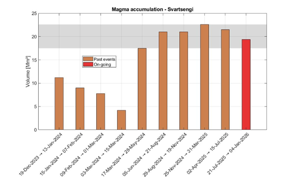
Just over 24 million cubic metres of magma have now accumulated beneath Svartsengi since the last eruption in July of last year. Model calculations indicate that the amount of magma in the magma reservoir beneath Svartsengi has never been higher since the eruption sequence began on the Sundhnúkur crater row in November 2023.
The results of model calculations, based in part on measurements of ground uplift, show the total volume for each magma accumulation period at Svartsengi since December 2023. The orange bars show the total volume that accumulated between magma intrusions or eruptions. The red bar indicates the volume that has accumulated from the eruption in July up to today.
As long as magma accumulation continues, a magma intrusion and eruption on the Sundhnúkur crater row remains the most likely scenario. Because the amount of magma beneath Svartsengi is now greater than before, it is possible that the next eruption could be larger than previous ones, if the magma reaches the surface in part or in full.
No signs that the eruption sequence is coming to an end
It is important to keep in mind that slow magma accumulation is not a clear indication that an eruption will not occur. The most immediate example of this is the Krafla Fires eruption sequence from 1975 to 1984.
Bjornsson and Eysteinnsson (1998), https://gogn.orkustofnun.is/Skyrslur/OS-1998/OS-98002.pdf
The graph shows the behaviour of the Krafla Fires and measurements of ground elevation in the Krafla caldera from 1974 to 1986. From 1975 to 1984, there were 12 magma intrusions (blue lines) and 9 magma intrusions that ended in eruptions (red stars). The magma inflow rate, which averaged about 0.75 m3/s, slowed considerably before the final, and also the largest, eruption in this eruption sequence in August 1984.
During the period from November 1981 to August 1984, the rate of magma inflow beneath Krafla decreased significantly. Despite the slow rate of magma accumulation for nearly three years, an eruption eventually occurred in August 1984, which was also the largest eruption of the Krafla Fires. Following the last eruption, continued ground uplift was measured until 1989, without culminating in an eruption.
Although there are fundamental differences between Krafla and the volcanic systems on the Reykjanes Peninsula, the comparison suggests that magma accumulation beneath Svartsengi could continue for several years and that the possibility of a new eruption remains.
No data indicate that the eruption sequence on the Sundhnúkur crater row is coming to an end, and the Reykjanes-Svartsengi volcanic system remains at Volcano Alert Level 2, “Heightened Unrest” (orange), as issued by the Icelandic Meteorological Office.
In order to state with confidence that an eruption sequence is over, clear signs must appear in monitoring data over a longer period showing the state of the volcanic system. This is reflected in the volcano alert level.
The Volcano Alert Level System (VALS) is a new system used by the Icelandic Meteorological Office. It is intended to communicate information in a simple way about activity in volcanic systems in Iceland.
Below, it is possible to see what signs must be observed in order to lower the alert level. When the volcanic system has been lowered to Alert Level 0, it can be said that the eruption sequence is over.
The graphic shows how the alert level is adjusted based on whether land inflation continues to be measured. If inflation continues, the alert level remains at 2, indicating significantly increased activity. If inflation is no longer detected for three months, the alert level is lowered to 1, indicating increased activity. If inflation is no longer detected for more than six months, the alert level is lowered to 0, indicating normal background activity.
It is important to bear in mind that even if magma accumulation stops for a few months, it may resume beneath Svartsengi.
Eruption sequences on the Reykjanes Peninsula can continue for decades or centuries, with pauses between events. A long pause between eruptions is therefore not an indication that the activity has ended.
Hazard assessment unchanged. The situation is marked by uncertainty
Model calculations, based in part on measurements of ground uplift, show that the rate of magma accumulation beneath Svartsengi has never been slower. The fact that magma accumulation has never been slower, while the amount of magma beneath Svartsengi has never been greater between eruptions, increases the uncertainty about developments in the area. It is not possible to say when a magma intrusion or eruption will occur, and the timeframe is measured in months.
The hazard assessment is unchanged and remains valid until 30 June unless there are changes in activity. The Icelandic Meteorological Office's 24/7 monitoring therefore continues to follow the area closely, and in light of the current situation, residents and others in the area need to be prepared for evacuations to be implemented at short notice.
Updated March 17
- Magma intrusion and an eruption along the Sundhnúkur crater row remain the most likely scenario
- Largest magma accumulation between eruptions since the onset of the eruption sequence
- A long pause between eruptions does not mean the eruption sequence has ended
- The Icelandic Meteorological Office is revising scenario assessments
- Hazard assessment unchanged and valid until March 31
Ground uplift and magma accumulation continue at a similar rate as in recent weeks, with magma inflow slow but steady. According to model calculations, more than 23 million cubic meters of magma have now accumulated beneath Svartsengi since the last eruption in July of last year. Magma accumulation beneath Svartsengi has never been greater since the beginning of this eruption sequence.
As magma accumulation continues and pressure in the system increases, the most likely scenario is a magma intrusion from Svartsengi toward the Sundhnúkur crater row, which could lead to an eruption. Since the volume of magma beneath Svartsengi is now greater than previously during this eruption sequence, it is possible that the next eruption could be larger than earlier ones, if the magma reaches the surface either partially or fully. The most likely location of a fissure or magma intrusion is in the area between Stóra-Skógfell and Sýlingarfell, where previous intrusions and eruptions along the Sundhnúkur crater row have occurred. The most likely location for a fissure eruption or dike intrusion is between Stóra-Skógfell and Sýlingarfell, where previous events have occurred within the Sundhnúkur crater row. However, the potential fissure opening area may be more extensive, extending from Grindavík in the south to areas northwest of Keilir.
The Icelandic Meteorological Office continues to work on further analysis of the possible evolution of the volcanic activity, and the results of that work will be presented at the end of March. It is important to note that a long pause between eruptions does not necessarily indicate that the eruption sequence at the Sundhnúkur crater row has ended.
Video of magma accumulation
A video showing model calculations of magma accumulation at a depth of 4 km beneath Svartsengi since July 17. The black dots show daily model estimates of cumulative magma volume from July 2025 to the present. The yellow area of the graph shows the lower bound of the modeled volume, reached in early October. The blue area shows the upper bound, reached around mid-February. The rate of magma accumulation has been variable, and therefore the timing of the upper and lower bounds has shifted. The calculations are based on a so-called Mogi model.
Seismic activity
Low seismic activity continues to be measured above the dike.
Hazard assessment
The Icelandic Meteorological Office hazard assessment remains unchanged and is valid until March 31. The IMO continues to closely monitor developments and will update the hazard assessment if changes in activity occur.
Updated 3 March
- A magma intrusion and eruption along the Sundhnúkur crater row remains the most likely scenario
- A prolonged pause in eruptions is not a clear indication that the eruptive episode has ended
- The Icelandic Meteorological Office is revising scenario assessments
- Hazard assessment unchanged and valid until 31 March
Land uplift and magma accumulation continue at a similar rate as in recent weeks; magma inflow is slow but steady. According to model calculations, approximately 22.5 million cubic meters of magma have now accumulated beneath Svartsengi since the last eruption in July last year.
Scenario assessments under review
Magma has been accumulating beneath Svartsengi for around 210 days, making this the longest continuous accumulation period since the eruptive episode along the Sundhnúkur crater row began in December 2023.
If magma accumulation continues at the same rate, it can be expected that by next week the total volume of magma accumulated since the last eruption will be the largest recorded between eruptions since the start of the eruptive episode.
The large volume of magma and the length of the accumulation period call for further analysis of the possible development of volcanic activity. The Icelandic Meteorological Office is currently revising its scenario assessments for possible developments, and these will be presented in the coming weeks.
It should be noted that a prolonged pause in eruptions is not a clear indication that the eruptive episode at the Sundhnúkur crater row has ended.
Seismic activity
Low seismic activity continues to be recorded above the magma intrusion. Seismic activity near Vík has decreased.
Hazard assessment
The Icelandic Meteorological Office's hazard assessment remains unchanged, and its validity has been extended until 31 March. The Office continues to monitor developments closely and will update the hazard assessment if there are changes in activity.
Updated 17 February
- Approximately 22 million cubic metres have accumulated since the last eruption
- This volume is approaching the higher end of what has been measured since the beginning of the ongoing events.
- A magma intrusion and eruption along the Sundhnúkur crater row is the most likely scenario
- Hazard assessment unchanged and valid until 3 March
Magma accumulation
Magma accumulation beneath Svartsengi is slow but steady, as it has been in recent weeks. According to model calculations, approximately 22 million cubic metres of magma have now accumulated beneath Svartsengi since the last eruption in July. This is among the largest volumes measured since the beginning of the ongoing events.
As magma continues to accumulate and pressure within the system increases, the most likely scenario in the coming weeks is a magma intrusion propagating from Svartsengi towards the Sundhnúkur crater row, which could culminate in an eruption. If an eruption occurs, it is most likely to be similar to the events that have taken place so far along the Sundhnúkur crater row.
Seismic activity on the Reykjanes Peninsula
Low seismic activity continues to be recorded in the Sundhnúkur area. Continued microseismic activity is measured in the Víkur area; this activity is interpreted as triggered earthquakes caused by stress changes in the area.
Hazard assessment
The hazard assessment remains unchanged and is valid until 3 March. The IMO continues to closely monitor developments and will update the hazard assessment should changes in activity occur.

Updated 4 February
- Around 21 million cubic metres have accumulated since the last eruption
- The maximum magma volume that has accumulated beneath Svartsengi is 22.6 million cubic metres
- Magma intrusion and volcanic eruption along the Sundhnúkur crater row are the most likely scenarios
- No signs of magma accumulation elsewhere on the Reykjanes peninsula
- The hazard assessment remains unchanged and has been extended until 3 March
Magma accumulation
The magma inflow rate beneath Svartsengi remains slow but steady, similar to recent weeks. According to model calculations, just under 21 million cubic meters of magma have now accumulated beneath Svartsengi since the last eruption in July 2025.
As magma accumulation continues and pressure within the system increases, the most likely scenario in the coming weeks is a magma intrusion from Svartsengi toward the Sundhnúkur crater row, which could culminate in an eruption. If an eruption occurs, it is most likely to be similar in character to previous events along the Sundhnúkur crater row.
Ground deformation and seismicity on the Reykjanes peninsula
Seismic activity in the Svartsengi area remains low.
On 28 January, a seismic swarm occurred near Lambafell, on the eastern part of the Reykjanes peninsula, with nearly 200 earthquakes recorded. In total, just over 260 earthquakes were detected in the area during the past week. The largest earthquake measured magnitude M3. This represents typical seismic activity for the area , with the last seismic swarm nearby Lambafell occurred in July 2024.
An interferometric synthetic aperture radar (InSAR) image, acquired by satellite and used to detect small surface deformations by comparing images taken at different times, was recently produced. The image covers the entire Reykjanes peninsula and shows that ground deformation is only detected at Svartsengi (uplift) and nowhere else on the peninsula.
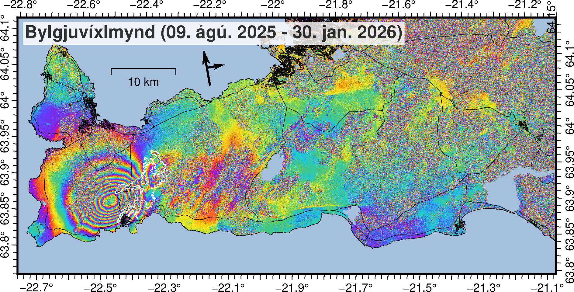
Satellite image (Bylgjuvíxlmynd; e. InSAR image) covering the period 9 August 2025–30 January 2026, showing ground uplift at Svartsengi.
Hazard assessment
The hazard assessment remains unchanged, and its validity has been extended until 3 March. IMO continues to closely monitor developments in the area and will update the hazard assessment if changes in the activity occur.
Updated 20 January
Magma accumulation continues beneath Svartsengi
Magma intrusion and volcanic eruption along the Sundhnúkur crater row are the most likely scenarios
Approximately 20 million cubic metres of magma have accumulated since the last eruption
Seismic activity remains low in the area
The hazard assessment remains unchanged until 3 February, unless activity changes
Magma accumulation
Magma accumulation beneath Svartsengi is slow but steady, similar to what has been observed in recent weeks. According to model calculations, nearly 20 million cubic metres of magma have now accumulated beneath Svartsengi since the last volcanic eruption in July.
As magma accumulation continues and pressure within the system increases, the most likely scenario in the coming weeks is a magma intrusion propagating from Svartsengi towards the Sundhnúkur crater row, which could end in a volcanic eruption. If an eruption occurs, it is most likely to be similar in character to the events that have occurred so far along the Sundhnúkur crater row.
Looking back to the onset of magma accumulation beneath Svartsengi in November 2023, total uplift amounts to just under 1 meter. The rate of uplift was highest at the beginning but has gradually decreased with each subsequent event.
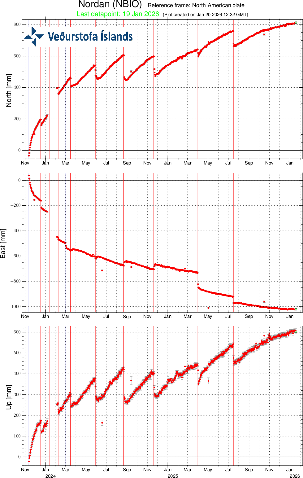
The graph shows measurements from the GNSS station NBJO since November
2023, illustrating the total ground uplift since the onset of activity
at Svartsengi.
Seismic activity
Seismic activity in recent weeks has been relatively stable, with earthquakes mainly located between Sýlingarfell and Stóra-Skógfell, south of Þorbjörn, and at Víkur. Most earthquakes are smaller than M1.5. Seismicity at Víkur is interpreted as triggered earthquakes caused by stress changes in the area. Seismic activity continues to decrease at Kleifarvatn.
Hazard assesment
The hazard assessment remains unchanged and is valid until 3 February. The IMO will continue to closely monitor developments and update the hazard assessment should changes in activity occur.

Updated 6 January 2026
Key points
- Magma accumulation continues beneath Svartsengi
- Continued increased likelihood of a magma intrusion and an eruption
- Earthquake activity remains low in the area
- Hazard assessment remains unchanged until 3 February, unless activity changes
- Magma accumulation
Land uplift and magma accumulation at Svartsengi continue at a steady rate, similar to recent weeks. According to modelling results, just over 19 million cubic metres of magma have now accumulated beneath Svartsengi since the last eruption in July. The likelihood of a magma intrusion and an eruption therefore continues to increase, but the timing of the next eruption remains uncertain and may range over several months.
Results of model calculations showing the total volume for each magma accumulation period at Svartsengi since December 2023. The orange bars show the total volume accumulated between magma intrusions or eruptions. The red bar represents the volume accumulated since the July eruption to the present day. The grey shaded area indicates the range of inflation volumes which accumulated beneath Svartsengi prior to triggering the last 5 events.
Earthquake activity
Earthquake activity in the area remains low.
Hazard assessment
The Icelandic Meteorological Office's hazard assessment remains unchanged and is valid until 3 February. The Office continues to closely monitor developments and will update the assessment if changes occur in the activity.
Updated 23 December 2025
Key points
Magma accumulation continues at a slow but steady rate
- As long as magma continues to accumulate, a new eruption must be expected
- Uncertainty regarding the timing of the next eruption is greater when magma accumulation is slow
- The hazard assessment remains unchanged until 6th of January unless activity changes
Adverse weather conditions in the coming days are likely to affect the sensitivity of monitoring instruments
Magma accumulation slow but steady
Magma accumulation beneath Svartsengi remains slow but steady, comparable to recent weeks. As long as magma accumulation continues, the likelihood of a magma intrusion and volcanic eruption remains elevated; however, uncertainty regarding the timing of the next eruption increases when magma accumulation is slow. Given the current rate of accumulation, the uncertainty in timing spans several months.
Measurements and modelling indicate that
since March 2024, the volume of magma required to trigger a magma intrusion or eruption has
increased. The amount of magma that has accumulated beneath Svartsengi between
eruptions since that time has ranged between 17 and 23 million cubic metres.
Since the last eruption in July, just over 18 million cubic metres of magma
has accumulated beneath Svartsengi.
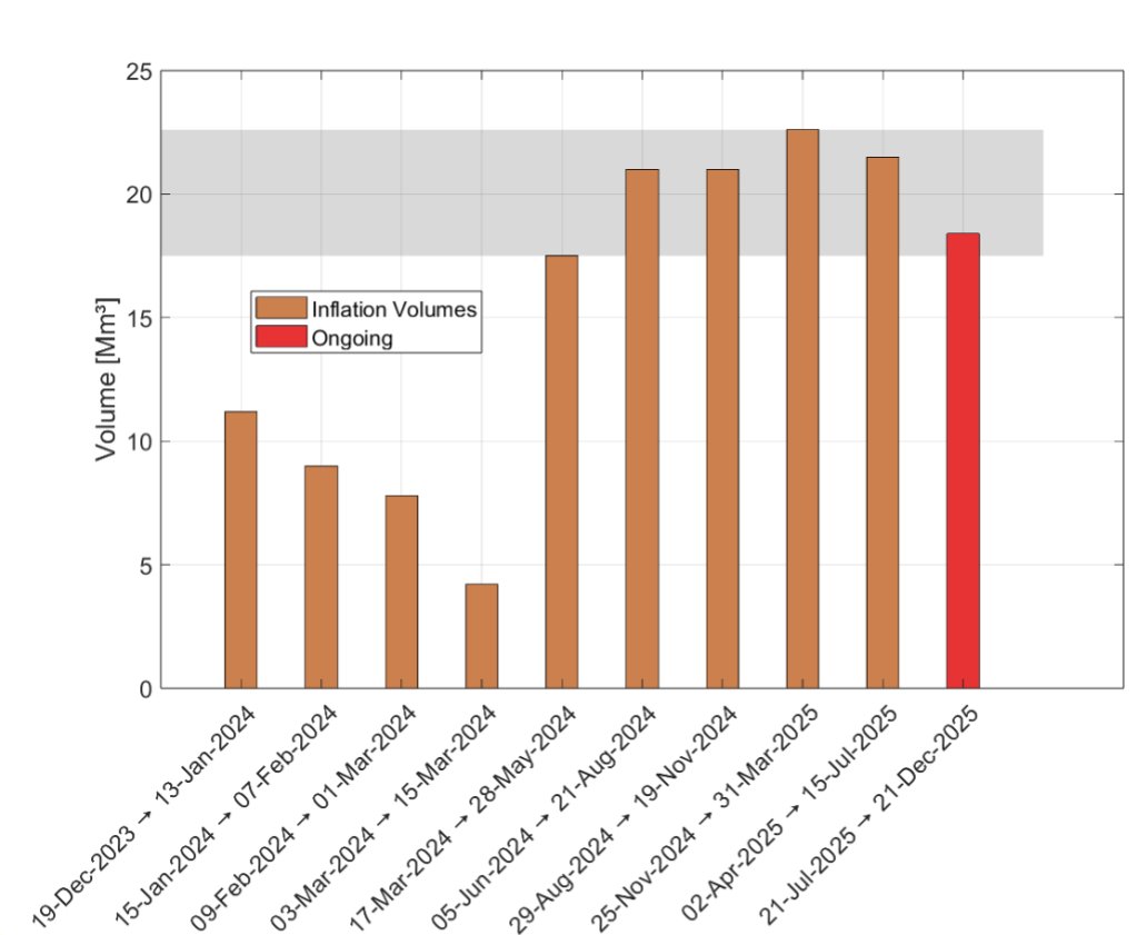
Results of model calculations showing the total volume for each magma accumulation period at Svartsengi since December 2023. The orange bars show the total volume accumulated between magma intrusions or eruptions. The red bar represents the volume accumulated since the July eruption to the present day. The grey shaded area indicates the range of inflation volumes required to accumulate beneath Svartsengi before triggering the next event.
Seismic activity remains low
Low seismic activity continues to be recorded in the Sundhnúkur area. Only five earthquakes have been detected over the past two weeks, the largest with a magnitude of 1.9, located between Þorbjörn and Hagafell on December 17th.
Hazard assessment unchanged
The Icelandic Met Office's hazard assessment remains unchanged and is valid until 6 January. The IMO continues to closely monitor developments and will update the assessment if activity changes.

Weather conditions may affect monitoring capability in the coming days
The weather forecast for the coming days predicts ongoing strong southerly winds on the Reykjanes Peninsula, accompanied by rain over the next three days. These conditions are likely to affect monitoring, particularly visibility and the sensitivity of fibre-optic cable, seismic, and real-time GPS observations. The Icelandic Met Office will continue to closely monitor developments around the clock.
Updated 11 December 2025
Key points
- Magma accumulation has been slow but steady in recent weeks
- As long as magma continues to accumulate, a new eruption must be expected
- Uncertainty regarding the timing of the next eruption is greater when magma accumulation is slow
- The amount of magma that has accumulated beneath Svartsengi since the last eruption is the fifth largest to date
- The hazard assessment remains unchanged until 6th of January unless activity changes
Magma Accumulation Slow but Steady in Recent Weeks
The magma accumulation process under Svartsengi is still ongoing . In the run-up to eruptions on the Sundhnúkur crater row, the rate of magma accumulation has varied. Looking at the past eruptions, model calculations show that the rate of inflow has gradually decreased with each eruption. Over the past two weeks, however, the rate has remained fairly steady.
As long as magma is accumulating, the likelihood of a dike propagation or an eruption remains elevated. The uncertainty regarding the timing of the next eruption is greater when accumulation is slow. Based on the current accumulation rate, the timing uncertainty spans months.
The Amount of Magma Accumulated Beneath Svartsengi Since the Last Eruption is the Fifth Largest to Date
Measurements and model calculations indicate that since March 2024, the volume of magma required to trigger a new diking event or eruption appears to have increased compared to earlier events. According to the models, the magma volume that has accumulated beneath Svartsengi between eruptions since March 2024 has varied between 17 and 23 million cubic meters. Model calculations now show that just over 17 million cubic meters of magma have been added to the accumulation area beneath Svartsengi since the last eruption in July. This is similar to the volume observed just before the May 2024 eruption.
Total modelled volumes for each inflation episode at Svartsengi since December 2023. The orange bars show the total volume that accumulated before the next intrusion or eruption began. The red bar represents the volume accumulated from the July eruption to the present day. The grey shaded area indicates the range of inflation volumes to re-accumulate beneath Svartsengi to trigger the next event.
Seismic Activity
Seismic activity in the area remains low. Twelve small earthquakes have been measured in the last two weeks, located between Stóra-Skógfell and Grindavík.
Hazard Assessment
The Icelandic Meteorological Office's hazard assessment remains unchanged and is valid until 6th of January. The IMO continues to closely monitor developments and will update the assessment if activity changes.
Weather Conditions in the Coming Days May Affect Instrument Sensitivity
The weather forecast for the area over the next few days predicts easterly winds of 15–23 m/s tomorrow morning with rain, followed by southeasterly winds of 10–18 m/s and showers in the afternoon. On Friday and through the weekend, windy conditions and intermittent showers will continue. These weather conditions may affect measurements, particularly visibility and the sensitivity of fibre-optic cable, seismic, and real-time GPS instruments. The Meteorological Office will continue to monitor the situation closely, but the public is encouraged to stay informed about weather warnings.
Updated 25 November 2025
Key Points
The rate of magma accumulation beneath Svartsengi has remained fairly stable over the past two weeks
The likelihood of a magma intrusion and an eruption remains elevated in the coming weeks
It is not possible to estimate the timing of the next eruption with greater accuracy than within a few months
The hazard assessment remains unchanged until 9 December
Assessment of the likelihood of a new magma intrusion and eruption based on modelling results
Uplift and magma accumulation beneath Svartsengi continues. The rate of magma inflow has remained relatively stable over the past two weeks. Modelling results indicate that approximately 16–17 million m³ of magma has accumulated beneath Svartsengi since the last eruption in July.
The amount of magma that intruded from Svartsengi into the Sundhnúksgígar crater row during the eruption that began on 16 July was estimated to be around 11–13 million m³. Based on previous eruptions along the Sundhnúkagígar crater row, the likelihood of a new magma intrusion and eruption is thought to increase once roughly the same volume of magma has reaccumulated beneath Svartsengi as was withdrawn during the preceding event.
In early October, modelling results indicated that about 11 million m³ of magma had reaccumulated beneath Svartsengi. At that time, a period began—still ongoing—during which the likelihood of a new magma intrusion and eruption is considered elevated.
Slower magma accumulation increases uncertainty in the timing of the next event
In the lead-up to eruptions along the Sundhnúksgígar crater row, the rate of magma accumulation has varied. The current magma inflow into the storage area beneath Svartsengi is estimated at around 1 m³/s. Modelling of geodetic data shows that the overall inflow rate has gradually decreased over time since the start of the activity in 2023. The slower the accumulation, the more difficult it becomes to estimate the timing of the next eruption. Based on current knowledge of the eruptions along the Sundhnúkagígar crater row, it is not possible to predict the timing of the next event with accuracy greater than a few months.
Experience from recent events has also shown that the accumulation rate does not need to change much for the timing of the next possible eruption to shift by several weeks. Uncertainty in the timing of the next event is therefore considerable, and the current magma accumulation period could continue for an extended time.
The magma volume recharged to the Svartsengi reservoir prior the past four events in Sundhnúks crater row has been assessed to have an upper bound of 23 millions m3. If a similar volume needs to be recharged before the next dike or eruption is triggered, and assuming the current accumulation rate remains unchanged, then this upper bound volume would be reached by early February 2026. The following graph illustrates the magma accumulation beneath Svartsengi since the most recent eruption along the Sundhnúkagígar crater row.
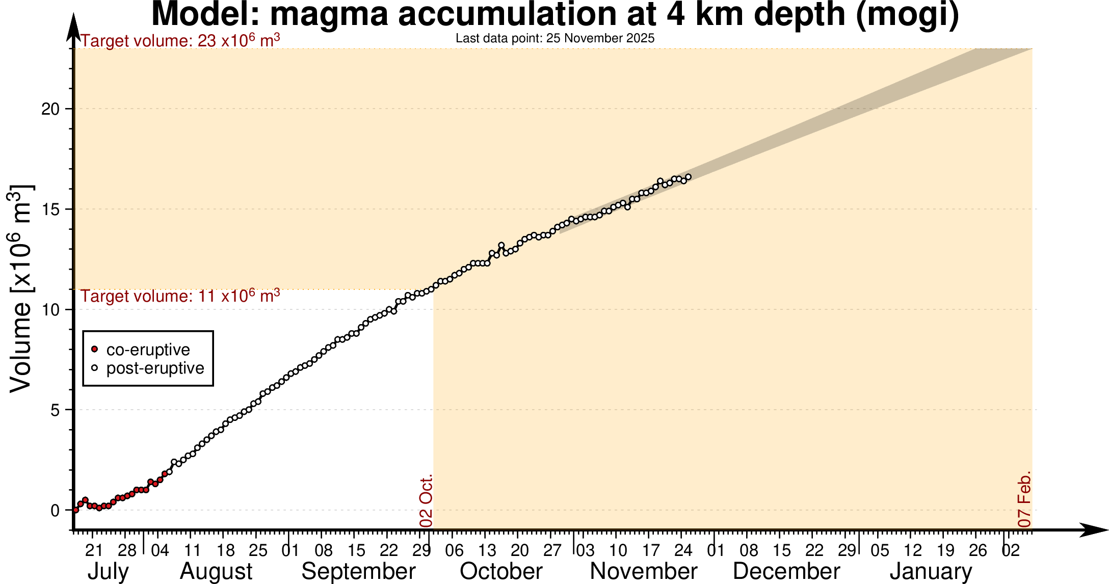
Model of magma accumulation at 4 km depth beneath Svartsengi since 17th July. The black circles show daily measurements of magma volume from July 2025 to the present day. The shaded area represents a forecast of magma accumulation at a constant inflow rate, while the red dashed line indicates a likely trend if the inflow rate continues to decrease. The volume thresholds of 11 and 23 million cubic meters are estimated model bounds for a potential magma intrusion and eruption.
Seismic activity at Svartsengi and krýsuvík
Seismic activity continues to be low at Svartsengi and Grindavík. Seismicity at Krýsuvík continues to decrease, and deformation measurements indicate that land subsidence at Krýsuvík has ceased.
Hazard assessment
The hazard map remains unchanged until 9 December. The Icelandic Meteorological Office will continue to monitor developments closely and update the assessment if changes occur in activity.
Updated 11 November 2025
Key Points
Deformation beneath Svartsengi continues, although at a slower pace than before.
There is still uncertainty regarding the timing of the next event.
The hazard assessment has been updated and remains unchanged until November 25, unless changes occur.
Seismic activity in Krýsuvík has significantly decreased in recent weeks.
Deformation Measurements
Deformation measurements indicate ongoing uplift and magma accumulation beneath Svartsengi, although the rate of magma inflow is gradually decreasing.
Based on previous events on the Sundhnúkur crater row, the likelihood of a new magma intrusion and eruption increases when a comparable amount of magma has accumulated beneath Svartsengi as before the last eruption. The amount of magma that has drained from Svartsengi during eruptive episodes since March 2024 has varied, ranging from 12–31 million cubic meters. According to model calculations, about 15 million cubic meters of magma have now accumulated beneath Svartsengi since the last eruption in July. Therefore, there is still considerable uncertainty about when the next event will occur.
As inflow decreases, the timeframe for a possible next event has lengthened. The accompanying graph shows that the lower volume threshold was reached in early October, while the upper threshold is projected to be reached in early February, assuming inflow remains unchanged. The upper threshold is set at 23 million cubic meters of magma, which is the average amount that has drained from Svartsengi during the last five eruptions.
Model of magma accumulation at 4 km depth beneath Svartsengi since 17th July. The black circles show daily measurements of magma volume from July 2025 to the present day. The shaded area represents a forecast of magma accumulation at a constant inflow rate, while the red dashed line indicates a likely trend if the inflow rate continues to decrease. The volume thresholds of 11 and 23 million cubic meters are estimated model bounds for a potential magma intrusion and eruption.
Seismic Activity
Earthquakes near Grindavík and along the Sundhnúkur crater row are few and small; most days only a handful of microearthquakes are detected, around or just above magnitude M1.
Activity near Krýsuvík
Deformation measurements show that the subsidence that began in Krýsuvík this summer has slowed significantly, and deformation is now minimal in the area. Earthquakes in Krýsuvík still occur a few times per day, but activity has decreased substantially. The total number of earthquakes has dropped from 250 down to 100–150 per week. This is the first time since summer that the earthquake pattern shows a continuous decline.
Hazard Assessment
The hazard map has been updated and remains unchanged until November 25. The Icelandic Meteorological Office continues to monitor developments closely and will update information if changes occur.

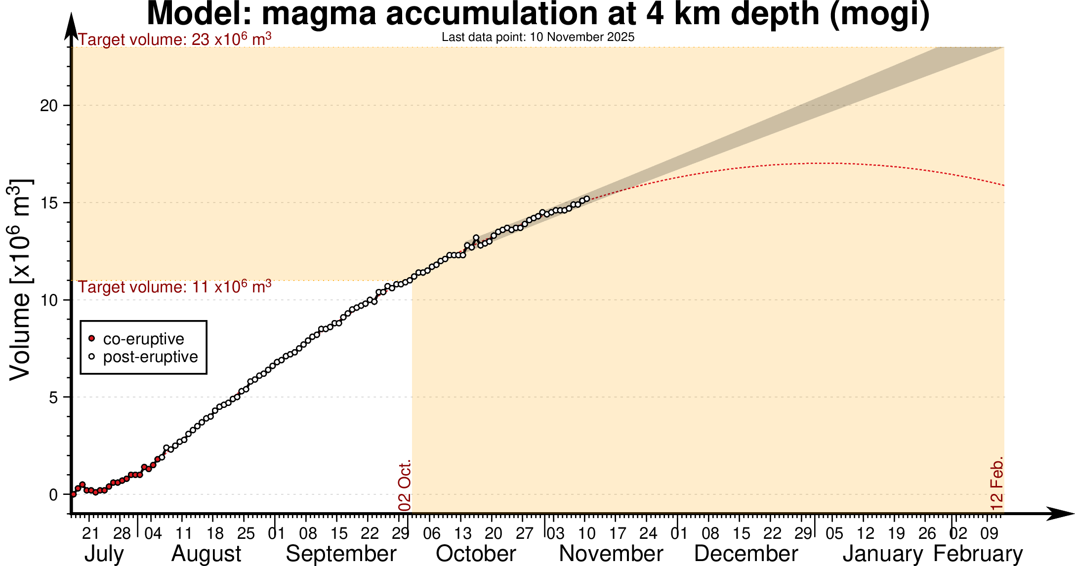
Updated 28 October 2025
Around 14 million
cubic meters of magma has accumulated
beneath Svartsengi since the last eruption
Key points
- Uplift and magma accumulation beneath Svartsengi continues.
- The volume of magma that has left Svartsengi during each magma intrusion event has ranged between 12 and 31 million cubic meters.
- There is still considerable uncertainty regarding the timing of the next event.
- The hazard assessment remains unchanged and is valid until November 11.
- Ground subsidence continues near Krýsuvík, though it has slowed in recent weeks.
Deformation
About 14 million cubic meters of magma have accumulated beneath Svartsengi since the last eruption. Based on previous events in the Sundhnúkur crater row, the likelihood of a new magma intrusion and eruption increases once a similar volume of magma has recharged beneath Svartsengi as was released during the last event. Looking at eruptions in the Sundhnúkur crater row since March 2024, the amount of magma that was released from Svartsengi each time has varied considerably — from 12 million to 31 million cubic meters. Therefore, there is still considerable uncertainty about the exact timing of the next event.
Earthquake activity
Seismic activity near Grindavík and the Sundhnúkur crater row remains rather low, with only occasional small earthquakes of around or just above magnitude 1.0 being recorded. Most of these are located between Hagafell and Grindavík. A short swarm of small earthquakes occurred along the Sundhnúkur crater row on October 11th, when just over 20 earthquakes were detected, however since then, the number has mostly been five earthquakes per day.
Activity near Krýsuvík
Earthquake activity near Krýsuvík continues, with numerous small earthquakes recorded daily. On October 22, two earthquakes larger than magnitude 3 occurred west of Kleifarvatn, measuring M3.1 and M3.6. On that day, over 120 earthquakes were recorded in the area. Subsidence, observed since the summer, also continues in the region — amounting to about 55 mm at the Móhálsadalur GPS station west of Kleifarvatn since early June. However, the rate of subsidence has decreased in recent weeks.
Hazard assessment
The Icelandic Meteorological Office's hazard assessment has been updated and will remain unchanged until November 11, unless activity changes.

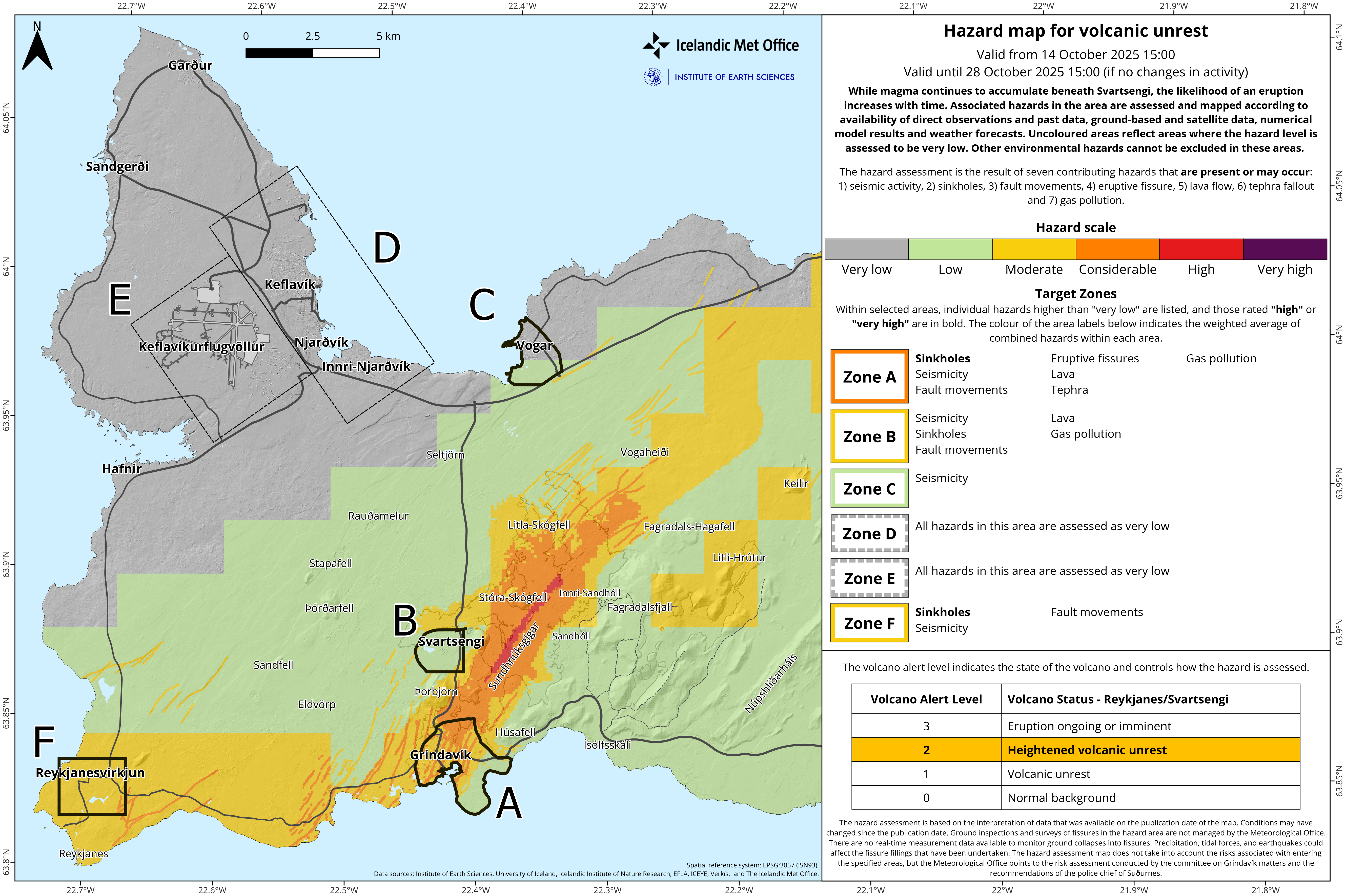
Updated 14 October 2025
Key points
A brief micro-earthquake swarm occurred east of Sýlingarfell on Saturday evening.
Deformation measurements over recent weeks indicate that uplift and magma accumulation continue beneath Svartsengi.
There remains considerable uncertainty about the timing of the next event.
The current hazard assessment remains unchanged and is valid for two weeks, unless activity increases.
Current situation
A short-lived micro-earthquake swarm was recorded east of Sýlingarfell on Saturday evening. The activity lasted about one hour before subsiding. No significant changes were observed in GPS measurements, fibre-optic strain data, or borehole pressure in Svartsengi during the swarm.
Similar micro-earthquake swarms have been observed a few weeks before previous eruptions along the Sundhnúkur crater row, such as those in May and November 2024. Increased seismic activity of this type indicates rising pressure in the magma accumulation zone, though the exact timing of the next event remains uncertain.
Deformation measurements
Deformation measurements in recent weeks show that uplift and magma accumulation continue beneath Svartsengi.
When looking at the rate of uplift over several weeks, there are indications that the rate has slowed slightly.
Since the last eruption, which began on 16 July, between 12 and 13 million cubic metres of magma are estimated to have re-accumulated beneath the Svartsengi magma storage area.
Based on previous events along the Sundhnúkur crater row, the likelihood of a new magma intrusion or eruption increases once a similar amount of magma has accumulated as was released in the last event. The volume of magma that left the system during that eruption is estimated at 11–13 million cubic metres, and the lower limit of that range was reached around the turn of the month.
Analysis of previous events has enabled the Icelandic Meteorological Office to estimate the range of accumulated magma volumes that could trigger the next intrusion or eruption.
The upper limit of that range is estimated at about 23 million cubic metres, which, according to model calculations, would be reached by late December, assuming the current accumulation rate remains steady.
There is therefore still considerable uncertainty regarding the timing of the next event.
Seismic activity and subsidence near Krýsuvík
Seismic activity continues near Krýsuvík, with numerous small earthquakes detected daily.
Ground subsidence also continues in the area, amounting to approximately 50 mm at the Móhálsadalur GPS station since early June.
Hazard map
The hazard map for the Reykjanes–Svartsengi area has been reviewed and remains unchanged until 28 October, unless new activity warrants an update.
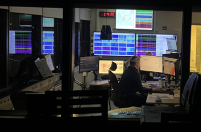
Continuous monitoring
The Icelandic Meteorological Office maintains 24-hour monitoring of all natural hazards in Iceland.
-
Real-time surveillance of seismic, deformation, and gas data
-
Warnings issued when necessary
-
Information on activity published in news updates on vedur.is
-
Situation reports shared daily with key stakeholders and response agencies
-
Weekly summaries on the status of volcanic systems distributed to relevant partners
More detailed information on Iceland's volcanic systems can be found on the Icelandic Volcano Web Portal: islenskeldfjoll.is
Updated 25 september
Entering new period of increased likelihood of an eruption
Increased likelihood of an eruption from 27 September
The volcano alert level for Reykjanes/Svartsengi is elevated from 1 to 2
A new hazard map is issued
Past behaviour of the Svartsengi volcanic system (since December 2023), has shown variability in magma volumes recharged to the Svartsengi reservoir prior to diking/eruption onset.
Analysis of past events has enabled an estimate of the likely volume range required to trigger the next diking event/eruption.
By using a geodetic model, it is possible to calculate the time needed to recharge these specific volumes, including their associated uncertainties. As of today, it is assessed that the lower bound of 11 million m3 will be reached on 27 September and the upper bound of 23 million m3 on 18 December, provided.
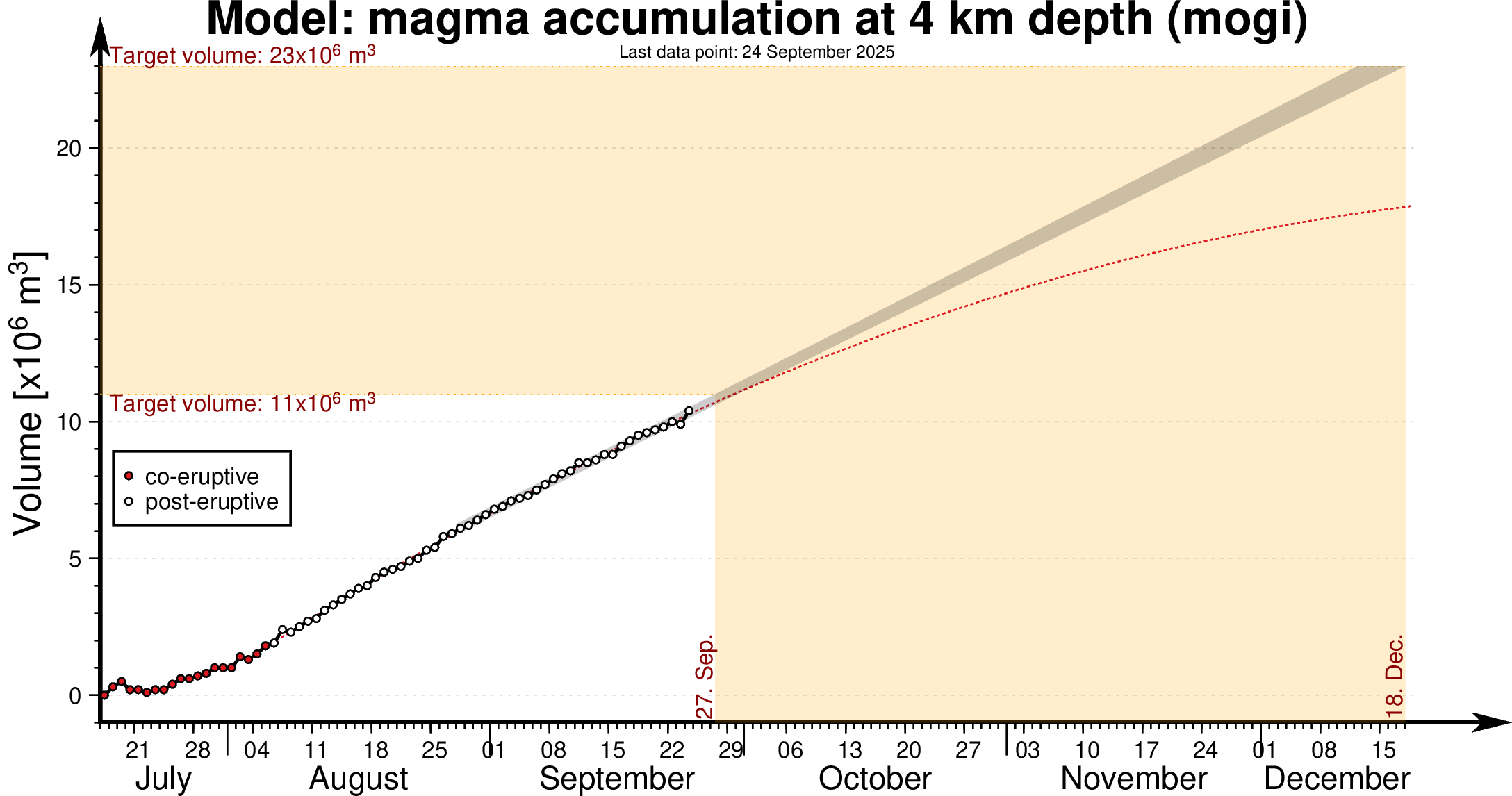 The graph shows magma
accumulation at a depth of 4 km beneath Svartsengi from July to 18
December 2025. The black dots indicate the measured magma volume after
the last eruption, while the red dots show magma accumulation during the
eruption.
The graph shows magma
accumulation at a depth of 4 km beneath Svartsengi from July to 18
December 2025. The black dots indicate the measured magma volume after
the last eruption, while the red dots show magma accumulation during the
eruption.
The magma inflow rate remains unchanged.
Once the lower volume is reached it is considered that we have entered a period with increased likelihood of a new diking event and eruption. An eruption may occur any time after this lower bound is reached. This time period from 27 September to 18 December represents the medium-term forecast. This forecast will change based on variations in the magma inflow rate and will be updated accordingly. As in previous events the short-term forecast will be issued as soon as the real-time IMO monitoring network detects new activity indicative of a dike propagation.
For these reasons the IMO decided to increase the volcano alert level for Reykjanes-Svartsengi from VALS=1 to VALS=2 and, accordingly, the hazard assessment for the area has been re-evaluated and elevated.
A new hazard assessment map has been issued

A new hazard assessment map has been issued and is valid from 25
September to 14 October, unless activity changes require an update
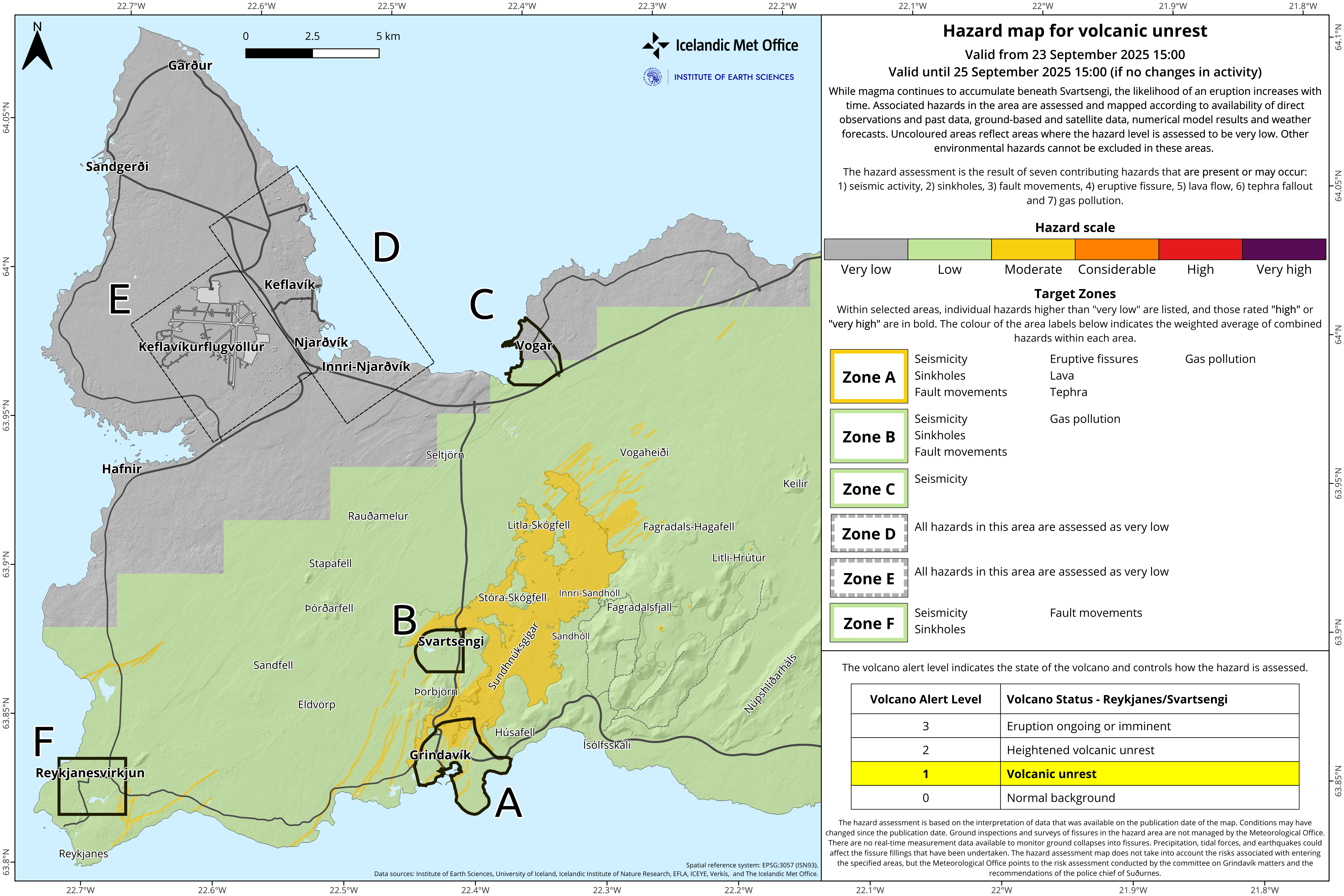
Updated 23 September
Magma accumulation under Svartsengi continues
The volume is approaching the amount that flowed out during the last event
- Around 10 million cubic meters of magma have accumulated under Svartsengi since the last eruption.
- The volume that flowed from Svartsengi during the last eruption was estimated at about 11–13 million cubic meters.The lower threshold of this volume is expected to be reached over the weekend.
- The hazard assessment remains unchanged but will be reassessed on Thursday.
Land uplift and magma accumulation continue under Svartsengi and have been at a steady rate in recent weeks. Since the last eruption, which began on 16 July, about 10 million cubic meters of magma have reaccumulated in the magma storage area beneath Svartsengi.
Based on previous events on the Sundhnúkur crater row, the likelihood of a new magma outflow and eruption increases once an amount of magma equal to the last event has accumulated beneath Svartsengi. The volume that flowed from the magma storage area during that eruption is estimated at about 11–13 million cubic meters. If the accumulation rate remains unchanged, the lower threshold of this volume is expected to be reached over the weekend.
Therefore, the hazard assessment will remain unchanged until this lower threshold is reached and will next be updated on Thursday, 25 September.
Experience shows, however, that the thresholds for when an event begins vary between eruptions. The uncertainty in the timing of the next event is therefore considerable, and the current period of magma accumulation could be prolonged.
Ongoing seismic activity and subsidence west of Kleifarvatn
Seismic activity around the Sundhnúkur crater row remains very low, with only occasional small earthquakes below magnitude 1.0.
Seismic activity near Kleifarvatn and to the west of it continues, with several tens of earthquakes measured there on most days. The majority of these earthquakes are small, below magnitude 2.0. Subsidence measured west of Kleifarvatn continues at a steady rate.
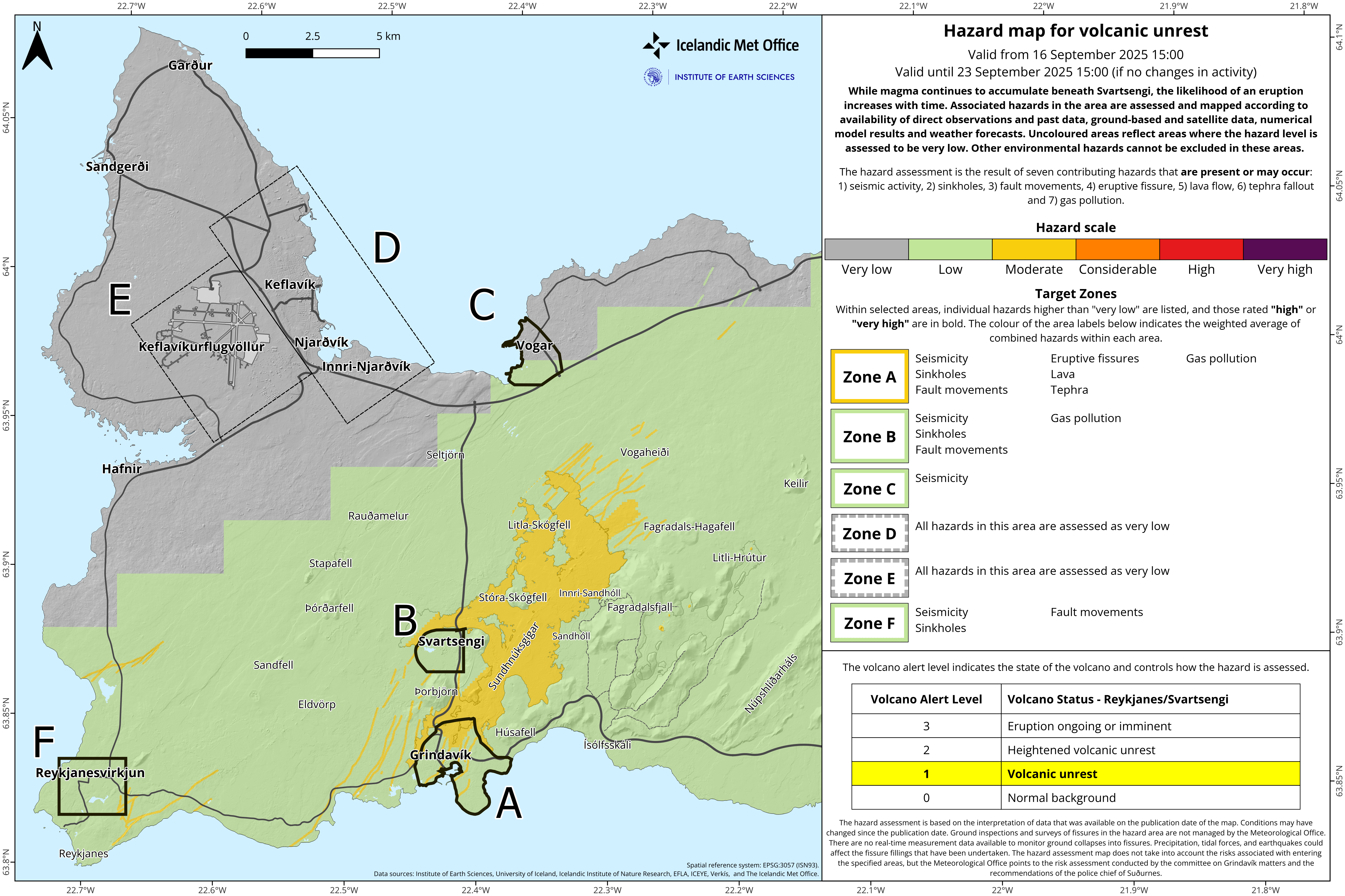
Updated 16 September
Hazard assessment unchanged but will be reassessed in one week
-
Uplift and magma accumulation beneath Svartsengi continues.
-
Approximately 8–9 million cubic meters of magma have accumulated beneath Svartsengi since the last eruption.
-
The likelihood of a new event increases when around 11 million cubic meters have accumulated, expected towards the end of September. However, there remains considerable uncertainty.
-
The hazard map remains unchanged but will be reassessed next week.
Uplift and magma accumulation
Measurements show that magma accumulation beneath Svartsengi continues at a similar rate as in recent weeks. Model calculations estimate that about 8–9 million cubic meters of magma have accumulated since the last eruption, which began on 16 July. The volume that drained from the accumulation area in that eruption was estimated at around 12 million cubic meters.
Likelihood of a new eruption
Based on previous events in the Sundhnúkur crater row, the likelihood of a new dike intrusion and eruption increases once a similar volume of magma has accumulated beneath Svartsengi as drained during the last event. If the accumulation rate remains unchanged, this volume will be reached in the latter part of September, as noted in the last hazard map update. However, experience shows that the thresholds for when an eruption begins vary between events. In some cases, eruptions have started at a lower volume, while in others a higher volume has been required.
Hazard assessment
The hazard map remains unchanged at this time. Given that the same volume of magma as drained in the last eruption is expected to be reached by the end of September, the hazard map will be reassessed next week. It will therefore remain in effect from 16 September to 23 September.
Updated 4 september
Considerable uncertainty about the timing of the next possible eruption on the Sundhnúkur crater row
- Uplift and magma accumulation under Svartsengi continues
- Around 6 to 7 million cubic meters of magma have accumulated beneath Svartsengi since the last eruption.
- It is assumed that when about 12 million cubic meters have accumulated, the likelihood of a new event increases.
- If the current rate of magma accumulation remains steady, the likelihood of a new event will increase in the latter half of September.
- A new hazard assessment is valid until 16 September.
- There is still some hazard on and around the new lava field.
Uplift and magma accumulation beneath Svartsengi continues and the rate of accumulation has been steady in recent weeks. Model calculations estimate that around 6 to 7 million cubic meters of magma have accumulated beneath Svartsengi since the eruption that began on 16 July. The volume of magma released from the storage area beneath Svartsengi during that eruption is estimated at around 12 million cubic meters.
Based on experience from eruptions on the Sundhnúkur crater row, it is expected that the probability of a new dike intrusion and eruption increases once approximately the same volume of magma has accumulated beneath Svartsengi as was released in the previous event. Looking at the most recent eruption, this suggests that once 12 million cubic meters have built up again, the probability of a new event will rise. At the current rate of accumulation, this volume will be reached in the latter half of September.
An eruption should be expected, but its timing remains highly uncertain
It is important to note that the volume of magma released from Svartsengi in each eruption since March 2024 has varied considerably, ranging from 12 to 31 million cubic meters. It is therefore unwise to assume that the next event will behave exactly like the last one. The previous event may have been unusual in terms of how much magma had to accumulate beneath Svartsengi to trigger an eruption. Experience from recent events also shows that even small changes in the accumulation rate can shift the timing of the next possible eruption by several weeks. The uncertainty in timing is therefore considerable, and the current accumulation period could last longer than expected.
The figure shows the magma accumulation periods on the Sundhnúkur crater row since October 2023. From March 2024 up until the eruption in July 2025, the accumulation periods had been lengthening.
Monitoring and preparedness assume an eruption could begin at any time
IMO's model calculations provide indications of when the likelihood of the next event may increase, but monitoring and preparedness plans are based on the assumption that an eruption could start at any time.
If an eruption does occur, the most likely source area is between Sundhnúkur and Stóra-Skógfell. Signs of an imminent eruption include microseismic activity and sharp deformation changes detected by fiber-optic and GPS instruments, as well as pressure changes in boreholes. The expected warning time before an eruption is short, as in previous events, ranging from 20 minutes up to just over 4 hours.
Continued hazard on and around the new lava field
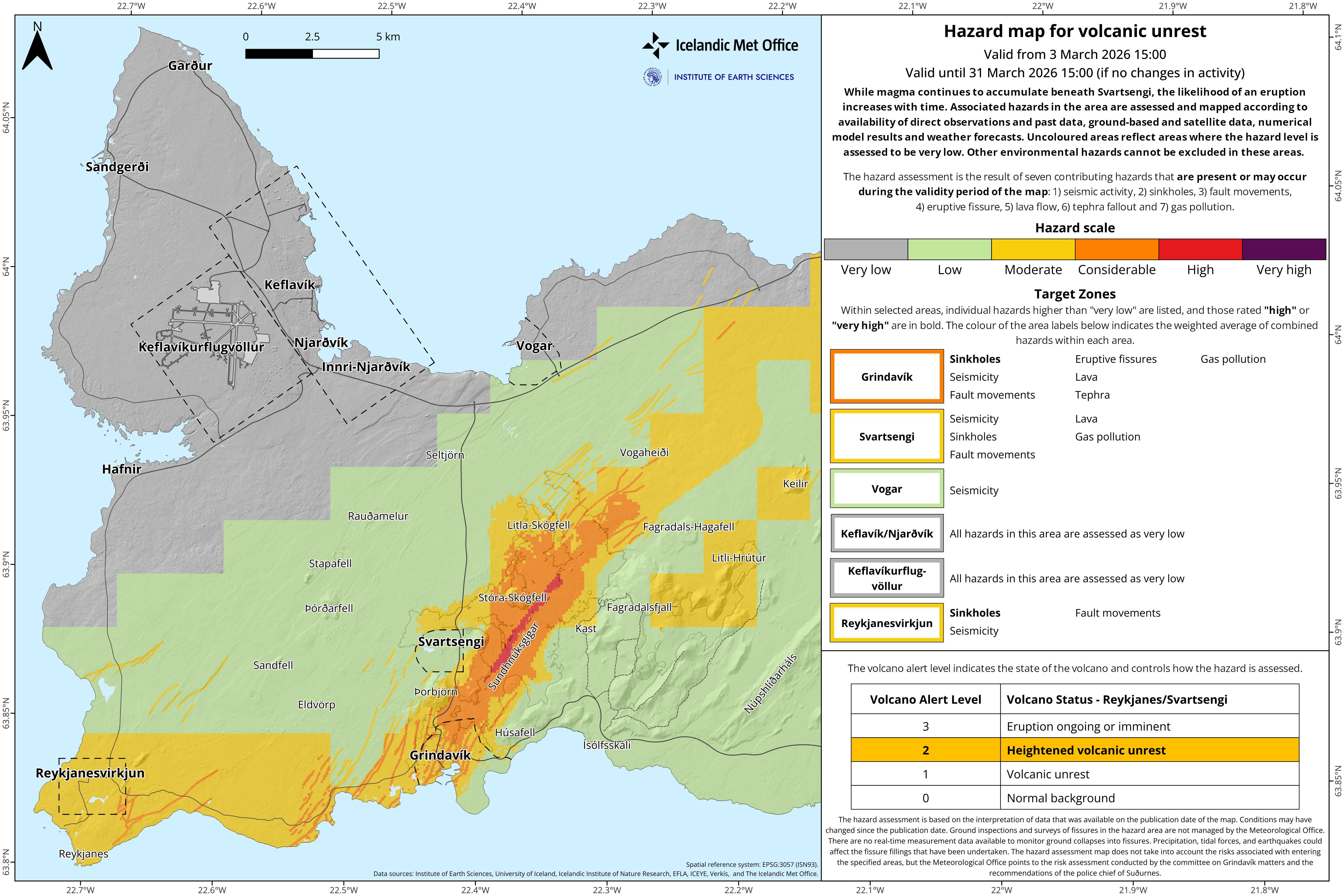
The hazard assessment has been updated and is valid until 16 September unless activity changes.
The main change from the previous hazard assessment is that the size of zone C (Vogar) has been revised. As a result, the hazard of ground collapse into fissures is no longer specified for this area. The new lava field remains in the category “some hazard” (yellow color).

Ongoing analysis and interpretation of activity in Krýsuvík
Seismic activity continues west of Lake Kleifarvatn. Krýsuvík and nearby areas are historically known for seismic activity, but recent unrest is mainly related to triggered earthquakes from magma intrusions beneath Fagradalsfjall and Sundhnúkur. In Krýsuvík, land subsidence is now being measured. The area has previously shown fluctuations of uplift and subsidence related to the geothermal system and possibly magma movements underground, but since eruptions began near Svartsengi in July 2023 the subsidence rate has increased compared to earlier. Further analysis of the activity is underway, but there are no indications that magma is moving closer to the surface in Krýsuvík.
Previous update – 19 August 2025
Earthquake in Brennisteinsfjöll – Faster Subsidence in Krýsuvík and Continued Magma Accumulation at Svartsengi
Potential for larger earthquakes in Brennisteinsfjöll
-
Deformation detected in the Krýsuvík area
-
Ongoing uplift at Svartsengi
-
Hazard map updated
An earthquake measuring magnitude 3.2 struck southwest Iceland shortly after 18:00 yesterday and was felt in the capital area. The quake was located in Brennisteinsfjöll, an active seismic zone. Since the onset of activity on the Reykjanes Peninsula in 2020, seismicity in this area has increased, reflecting growing stress accumulation in the crust.
It should be noted that strong earthquakes recur in this region, although at long intervals, and it is uncertain when the next might occur. The last major events were M6.4 in 1929 and M6.1 in 1968. Since then, building standards have steadily improved with stricter requirements for earthquake-resistant design. While earthquakes of this size can trigger rockfalls in steep slopes and cause household items to shift, injuries in Iceland are rare and most often result from unsecured objects falling during shaking.
In earthquake-prone areas it is advisable to take preventive measures to reduce the risk of damage, such as securing heavy objects so they are not placed above beds, and reviewing guidelines on how to respond during earthquakes.
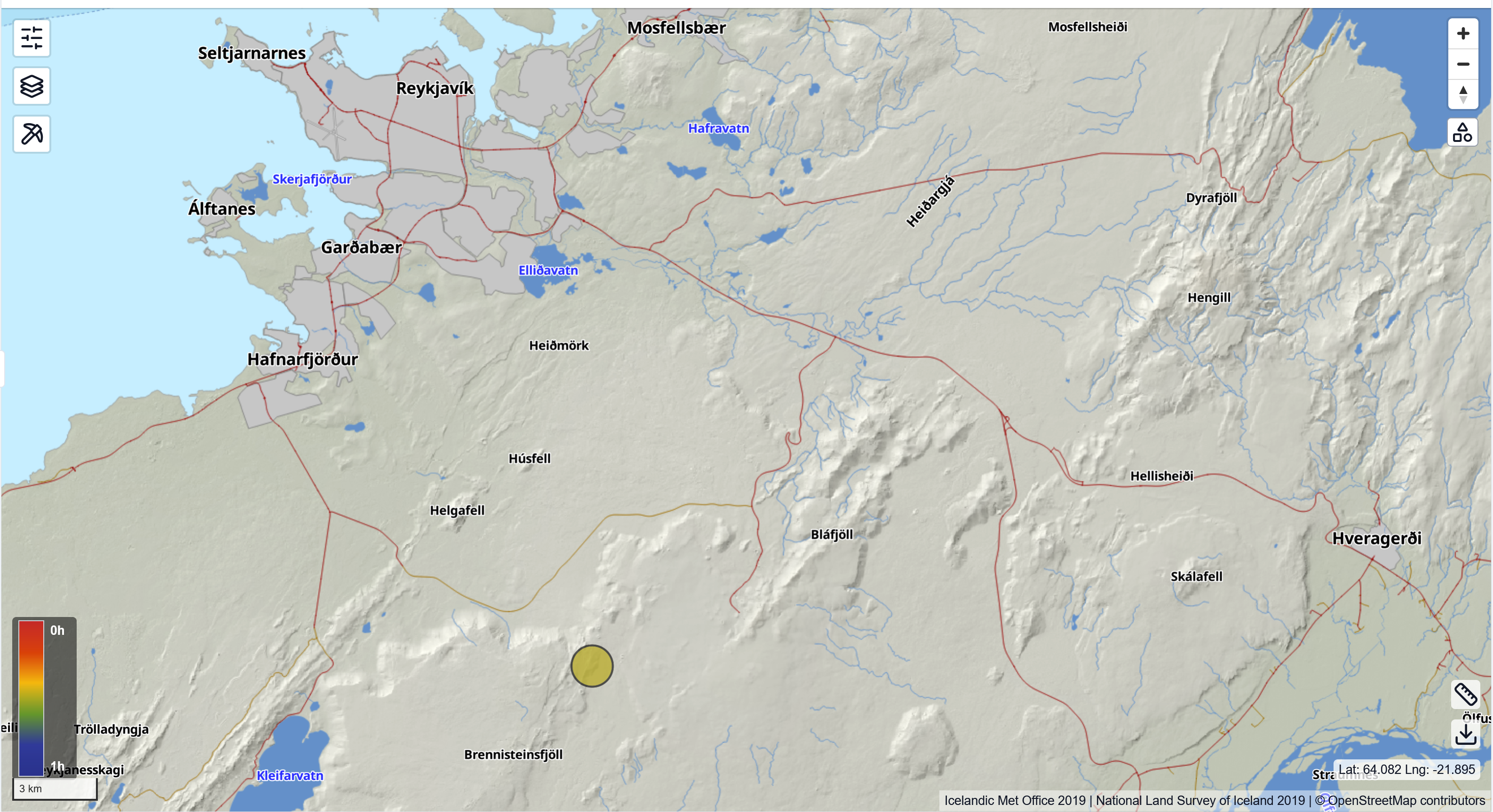
The epicenter of yesterday's earthquake in Brennisteinsfjöll. It measured M3.2 and was widely felt in the capital area.
Some seismic activity has also been recorded west of Kleifarvatn. Krýsuvík and nearby areas are historically known for earthquakes, but recent activity is mainly linked to intrusion-related quakes beneath Fagradalsfjall and Sundhnúkur. At Krýsuvík, both uplift and subsidence have been measured. The area has shown such fluctuations before, but the current deformation appears faster than previously observed. Further analysis is underway.
Experts are closely monitoring the situation, assessing data daily and communicating findings as needed.
Magma accumulation continues beneath Svartsengi at a rate similar to that before the last eruption. No seismic activity has been detected in the area since the eruption began.
Ground deformation
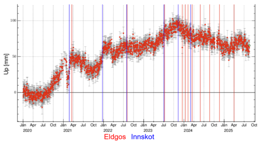
The figure shows vertical ground motion in Krýsuvík measured by the KRIV GPS station since 2020. In the first years, the land rose steadily, but since autumn 2023 it has been subsiding. Following the eruption at Svartsengi in July 2023, the subsidence has accelerated.
The record also shows regular fluctuations linked to magma movement underground. Since last summer, the subsidence has coincided with increased seismicity in the area, which is a normal response when magma shifts in the crust and redistributes stress.
For comparison, InSAR satellite images are used to measure small surface changes by comparing images taken at different times. These confirm the same pattern as the GPS measurements.
The hazard map for the area has been updated and is valid until 2 September unless conditions change. The main update is that the new lava field has been downgraded to the “some hazard” category (yellow), the same as older lava fields.