
News
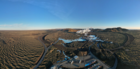
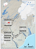
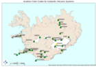
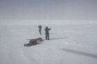
Continued Uplift in Svartsengi
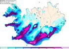
Update 1. July
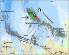
Uplift and earthquake activity are ongoing in the Svartsengi area, with stable activity levels in recent weeks. On average, about 10 micro-earthquakes are detected per day, most of them located north of Grindavík.
No substantial changes have been detected in measurements that would prompt a reassessment of the hazard level. However, continued magma accumulation could increase the likelihood of a magma intrusion or volcanic eruption in the coming autumn.
Read more
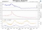
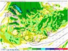
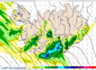
Analysis: Climate change made the May heatwave more likely and more intense
In May 2025, an unusually intense heatwave struck Iceland and eastern Greenland, breaking numerous temperature records. On 15 May, Iceland's national May temperature record was set at 26.6°C at Egilsstaðir Airport, with several locations recording temperatures up to 13°C above the monthly average.
A new international analysis by the World Weather Attribution group shows that human-induced climate change made this heatwave around 40 times more likely and, on average, three degrees Celsius hotter than it would have been without global warming. The study also suggests that if global temperatures rise by 2.6°C, such heatwaves could become at least twice as frequent and two degrees hotter.
Read more
The most significant May heatwave ever recorded in Iceland
Temperatures
reached or exceeded 20°C at several weather stations for 10 consecutive
days.
May temperature records were repeatedly broken at weather stations across the country.
A new national May temperature record of 26.6°C was set at Egilsstaðir Airport on May 15th.
Read more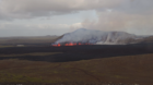
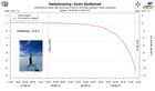
Uplift continues beneath Svartsengi
Updated April 8, at 16:15 UTC
Deformation measurements clearly show that uplift beneath Svartsengi is ongoing. The current uplift rate is faster than that observed following previous eruptions. This may be explained by the large volume of magma — around 30 million cubic meters — that was released from the system during the most recent event.
However, it is still too early to predict how the rate of magma accumulation will develop. Past events have shown that accumulation rates typically decline as more time passes between eruptions. At least a week, and possibly several weeks, will need to pass before we can evaluate if — and how — the rate of accumulation will change.
Read more
Eruption at the Sundhnúkur crater row remains likely
Updated 25. March at 15:00 UTC
GPS deformation data shows that magma continues to accumulate beneath Svartsengi, although the pace of land uplift has slightly decreased in recent weeks. Despite the slower uplift, experts still consider it likely that a magma intrusion and/or eruption will occur along the Sundhnúkur crater row.
Read more
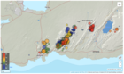
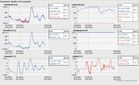
Earthquake swarm ongoing offshore Reykjanestá
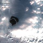
At around 14:30 yesterday (12 March 2025), a rather intense earthquake swarm began offshore Reykjanestá. The swarm was most intense at the beginning when about 50 – 60 earthquakes were recorded in the first few hours. As the day progressed, the activity decreased but then increased again shortly before midnight when an earthquake of magnitude 3.5 occurred. When the activity increased again in the evening, it shifted slightly westward as the image shows (blue circles indicate the location of earthquakes that occurred at the beginning of the swarm yesterday, while yellow and red ones show earthquakes from late last evening and night).
Read more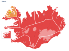
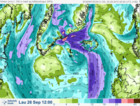
Red weather warnings in effect today – no travel recommended
A southerly storm or violent storm is expected later today and tomorrow, with very strong wind gusts, widely 35 – 45 m/s and especially near mountains, but locally exceeding 50 m/s. Considerable or heavy rain is expected in the south and the west regions of the country. More details can be found here.
Read moreThe weather in Iceland in 2024
The year 2024 was remarkably cold compared to temperatures of this century. The national average temperature was 0.8 degrees below the 1991 to 2020 mean, and it was the coldest year since 1998. Lowest relative temperature was inland in the North, while it was warmer along the southern coast. The summer was wet across the entire country, but other months of the year were relatively dry. Overall, the year was drier than average in the eastern, southern, and southwestern parts of the country, but wetter than average in the North and West, which experienced heavy rain during summer. The sea level pressure was unusually low from June through August, and the summer was characterized by frequent low-pressure system passage and unfavourable weather. During other seasons, the weather was relatively calm, and annual mean seal level pressure and wind speed were around average.
Read more
New weather forecast website launched
The first phase of the Icelandic Meteorological Office's (IMO) new website was launched today. This marks the beginning of a major project aimed at renewing both the website and its entire technical infrastructure.
The new weather forecast website is available at https://gottvedur.is/en/. While the site is still in development, once the renewal of the current website is complete, the new weather pages will be moved to the domain vedur.is.
Read more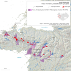
Earthquakes continue to be recorded at great depths near Grjótárvatn
Updated 17. January 14:00 UTC
Seismic activity continues to increase near Grjótárvatn. So far in January, nearly 100 earthquakes above M1.0 have been recorded. This is comparable to the total number of earthquakes in December 2024, which was the highest monthly count ever recorded in the area.
Read more
Strong earthquake swarm in Bárðarbunga. Largest earthquake magnitude 5.1
A strong earthquake swarm began shortly after 6:00 UTC today in the
northwestern part of the Bárðarbunga caldera. Approximately 130 earthquakes
have been recorded since the swarm began, with the largest reaching magnitude
5.1 at 8:05 UTC.
Additionally, 17 other earthquakes with a magnitude of 3 or higher were detected, including at least two measuring magnitude 4 or above. These estimates may change as analysis of the events is ongoing.
Read more
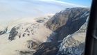
Glacial outburst flood from Grímsvötn likely in progress
In recent days, a gradual increase in seismic tremor has been recorded on the Grímsfjall seismometer, suggesting that a glacial outburst flood has begun from Grímsvötn. These floods emerge from the base of Skeiðarárjökull glacier, flowing into the Gígjukvísl river. Typically, these glacial outburst floods increase gradually, and it can take a few days for the first signs of floodwater to be detected at the hydrological station in Gígjukvísl river and an additional few days before peak discharge is reached. With precipitation in southeast Iceland in the past days, and more expected in the coming days, the identification of the initial signs of the flood In Gígjukvísl could prove to be challenging.
Read more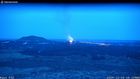
Ground uplift under Svartsengi area continues at a stable rate
A photogrammetric survey was conducted by Icelandic Institute of Natural History and Landmælingar Íslands in a flight over the eruption site 13 December. The data reveals that the lava field that was formed during the last eruption (20 November to 9 December) had a total volume of 49,3 million cubic meters erupted and covered an area of 9,0 square kilometers. The thickest part of the lava field was around the craters and close to the barriers by the Blue Lagoon but the average thickness of the lava was 5,5 meters.
Read more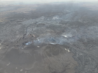
Ground Uplift and Magma Accumulation Continue Beneath Svartsengi
Updated 19. November at 14:45 UTC
Seismic activity in the Sundhnúkar crater row remains relatively low. A few earthquakes have been recorded daily, most of them located between Stóra-Skógfell and Sýlingarfell. On some days in the past week, bad weather has affected the sensitivity of the seismic monitoring system, potentially obstructing the detection of the smallest earthquakes.
Read more
Continued greenhouse gas emissions could trigger a regional cooling around the North Atlantic
Continued greenhouse gas emissions increase global warming, but could trigger a regional cooling around the North Atlantic. In an open letter released today at the Arctic Circle conference in Reykjavík, Iceland, 44 leading experts on ocean circulation and tipping points from 15 countries appeal to the Nordic Council of Ministers to take this risk seriously, initiate a risk assessment and take steps to minimize this risk as much as possible.
Read more
New Icelandic Met Office weather and climate supercomputer, becomes operational
The National Meteorological Institutes of Iceland, Denmark, Ireland and the Netherlands have joined forces to respond to climate change with more timely weather forecasting on a new, now operational, common supercomputer. This helps prepare each nation for the impacts of weather patterns, which are expected to become more extreme and more challenging to forecast.
Read more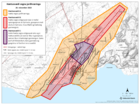
Important to continue developing volcanic hazard assessment methodology
The Icelandic Meteorological Office is legally responsible for real-time natural hazard monitoring and to provide warnings and forecasts of impending hazards from e.g. earthquakes, volcanoes and glacial outburst floods. The Met Office also has the role of advising authorities about the prevention of and response to natural hazards. Part of this responsibility is to regularly assess and provide information about volcanic hazards such as he recent unrest on the Reykjanes Peninsula.
Read more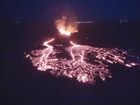
One month since the start of the eruption at the Sundhnúkur crater row
Today marks one month since the beginning of the eruption that is ongoing at the Sundhnúkur crater row. The eruption, which began on the evening of March 16, is the fourth in a series of eruptions that started when magma began accumulating beneath Svartsengi in late October 2023.
Read more
Seismic swarm in the northwest past of the caldera in Askja yesterday
Yesterday (25 March) a seismic swarm occurred in the NW part of the Askja caldera. About 30 earthquakes were detected between 08.00UTC and midday. The largest earthquake detected had a magnitude M3,5 at a depth of about 5 km. Three earthquakes with magnitudes between M2 and M2,5 were also detected, the rest of the activity was characterized by smaller events. Overall, the seismic activity in the Askja has been quite stable between months and unchanged until yesterday. Looking back, we can see that earthquakes with magnitude above M3 were detected in January 2022 and October 2021.
Read moreThe weather in Iceland in 2023
The weather in 2023 was mostly favorable. It was calm, dry, relatively little snow and stormy days were quite uncommon. However, the year was cooler compared to the most recent years. The average nationwide temperature was 0.1°C colder than the average temperature between 1991 and 2020, and 0.4°C colder than the average temperature of the last ten years. It was relatively coldest in the North, while the Southwest and Southern coast were relatively warmer. The weather was particularly cold in the beginning of the year and again in March. June, on the other hand was exceptionally warm in the North and East. It was the warmest June on record in many places in those regions. The year was relatively dry, with precipitation below average across most of the country. There were several dry periods during the year, such as in March and July, but there were also periods of heavy rain in between. May and June were particularly wet and gloomy in the southern and western regions.
Read more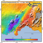
New understanding of ultra-rapid formation of magma filled cracks in the Earth
On 10 November 2023 the town of Grindavík in Iceland was evacuated as massive amounts of magma suddenly flowed into a magma filled crack that propagated underneath the town. Magma was emplaced in a 'vertical sheet' type intrusion in the Earth's crust. An international team of scientists explains the formation of the intrusion, and conditions for ultra-rapid flow into cracks, in a new publication in the prestigious scientific journal Science.
Read more
Conclusion of Grímsvötn Glacial Outburst Flood
Updated 23 January at 9:00 UTC
Since the glacial flood reached its peak in the river Gígjukvísl approximately a week ago, the water level has been decreasing and is now comparable to what it was before the flood. The seismic tremor measured on the seismometer at Grímsfjall has also declined, with seismic noise now back to normal levels. Since last week Monday, 21 earthquakes have been recorded in Grímsvötn, including two earthquakes exceeding magnitude two.
Read more
The uplift in Askja has slowed down
There is evidence of recent changes in the deformation data (cGNSS) around Askja. The deformation rate has decreased since the beginning of August and the signal has flattened at several stations within or around the caldera. At this stage it is uncertain what process is causing this pressure reduction, possibly the source of the inflation has been shut off or it could be related to an outflow of magmatic fluids.
Read more
Flood in Skaftá
Updated on 29 August, at 17:00
Hydrological measurements in Skaftá at Sveinstindur show that the increase in discharge has slowed down.The discharge is estimated 620 m3/s at 15:00 compared to 600 m3/s at 9:00 this morning.
Read more
No visible changes in geothermal activity around Askja and Víti
The field trip conducted by a team from IMO last week has been completed succesfully.
Preliminary results indicate no
changes in the gases or waters compared to previous years while
further sample and data analyses are ongoing. Visual inspections
and temperature and pH measurements do not point to
any clear changes in geothermal activity around Askja including
in Víti. The observation on 12 August at the edge of
Bátnshraun which was reported as a possible steam plume is now recognized
as dust caused by a minor rock fall on a steep slope of the
caldera wall.
The situation at Askja remains unchanged
The latest deformation data indicates that the inflation continues at Askja with the position and depth of the inferred magma source unchanged since September 2021. The magma is accumulating at a depth of about 3 km, and there are currently no indications from geodetic observations that the magma has shallowed further. Ten days have passed since last activity was seen in the crater close to Litli-Hrútur and since volcanic tremor reached its background level. No deformation is detected in the area and the seismic activity has decreased significantly.
Read more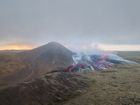
The activity in the Reykjanes Peninsula has entered a new phase
Updated 10 August 2023
The Icelandic Met Office has updated the hazard map for the eruption site. The vicinity of the eruption area is still dangerous. High temperatures characterize the lava field. The solidified crust can be very thin in places with very hot and molten lava underneath. The edges of the new lava field are unstable and large chunks of lava can fall sudden. As a result of past activity there are fractures in the area that pose danger. The new lava continues degassing and hazardous gases can collect in depressions
Read more
Earthquakes in Mýrdalsjökull
There has been increased earthquake activity around Katla the past few days. An earthquake sequence started shortly after midnight 30. June. By 6:30 in the morning, 95 earthquakes had been detected, 8 over M3 and the largest was M4.4. The earthquake activity in Mýrdalsjökull the past weeks has been the most that has been measured there since fall 2016. Unusually high electrical conductivity for this time of year has been measured in Múlakvísl. Gases associated with geothermal waters have been measured at Láguhvolar. The measurements suggest elevated geothermal activity as the cause of the observed changes but it is not possible to exclude the possibility of magma movements.
Read moreNo changes in activity seen at Grímsvötn
Since the beginning of the year around 10 to 30 earthquakes (> M1.0) have been detected each month in Grímsvötn.
The end of April – the beginning of May were the most active periods
with the largest earthquake of this year so far was a M3.3 on the 23.
April. Since the middle of May the seismic activity has decreased.
Askja volcano continues to inflate at a steady rate and there is currently no indication of an escalation in activity
No clear signs of an increase in activity at Askja
Seismic activity around Askja increased in August 2021 as uplift, most likely caused by a magmatic intrusion, began. The seismic activity was more elevated in November and December 2021 and has since the start of 2022 remained steady. At the same time, the uplift has continued at a very stable rate since the beginning of the unrest.
Read moreThe weather in Iceland in 2022
The ice covering the lake in Askja is melting
Recent
satellite images show that the ice covering Askja lake has been retreating
significantly in the past week. Thisis quite unusual so early
in the year, normally it occurs in the summer time between June and July. A similar
event was recorded in 2012 when the ice in Askja lake started to melt in March. The reason why the ice covering the Askja lake has retreated
so much in the past days is still uncertain and no direct measurements are
currently available to fully understand the causes. However, few causes have been considered.
New project on effects of climate change induced ice-retreat on seismic and volcanic activity
Retreating ice caps
have a large influence on the crust of the Earth and cause ground uplift – a
rebound effect resulting from unloading of the glaciers due to ice loss. Dr. Michelle Maree Parks, a specialist
in volcano deformation studies at the Icelandic Meteorological Office, together
with Freysteinn Sigmundsson, a geophysicist at the Nordic Volcanological Center
at the Institute of Earth Sciences, University of Iceland, lead a project that
received a grant-of-excellent from the Icelandic Research Fund that addresses
these questions. They will together form a large international team of
scientists to carry out research on glacial isostatic adjustment due to present
day glacier change and its effect on the Earth‘s crust, in particular at four
volcanic systems and two seismic zones in Iceland.
Minor jökulhlaup in Grímsvötn
Updated 13.10.
The glacial flood from Grímsvötn is still ongoing and maximum discharge of about 500 m3/s from Grímsvötn sub-glacial lake is expected to be reached later today or tonight. The ice-shelf on top of the sub-glacial lake has now subsided approximately 12 m since 5th of October. Since yesterday morning signals of floodwater have been detected in Gígjukvísl river by water level measurements and on images from a web camera
Read more
Fagradalsfjall eruption unusual in many ways compared to other eruptions
The precursors to the eruption at Fagradalsfjall last year were unusual compared to many other eruptions across the world and the composition of the lava changed as the eruption continued. These are among the findings of two papers published in the latest issue of Nature by scientists at the University of Iceland and the Icelandic Meteorological Office along with a large number of colleagues.
Read more
„We need to control our footprint on mother Earth“
The president of Iceland, Guðni Th. Jóhannesson, opened the science symposium Cryosphere 2022 in Harpa concert hall this morning. The Icelandic Meteorological Office (IMO) is organizing the conference focusing on ice and snow in a warming world. About 330 scientists participate in the symposium from 33 countries of 6 continents.
Read more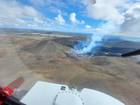
Latest news on the eruption at Reykjanes peninsula
Updated 23.8.2022
The eruption in Meradalir, which commenced on the 3rd of August, ceased to issue lava on the 21 of August. Volcanic tremor started to decrease steadily from the 18th and stopped completely during the night of 21st. The activity at the crater ceased at the same time, with no visible extrusion of fresh lava.
Read more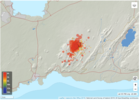
Status of unrest in Reykjanes
Preliminary deformation modelling results suggest the top depth of the new dike intrusion beneath Fagradalsfjall is very shallow - about 1 km. The magma inflow rate is rapid, almost double that observed during the first dike intrusion in february-march 2021.
Read more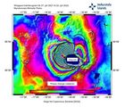
Status of unrest in Askja
A meeting was held with scientists from the Icelandic Met Office, Institute of Earth Science and the Department of Civil Protection and Emergency Management to follow up on the status of unrest in Askja. Since august 2021 an uplift of 35 cm centered west of the Askja lake has been measured.
Read moreEarthquakes on the Reykjanes peninsula
More than 3000 earthquakes have been automatically detected nearby Eldvörp in the Reykjanes/Svartsengi volcanic system in the past week. Since yesterday (15.05), nine earthquakes had magnitude above M3 and two above M4. The largest event had a magnitude of M4.3 occurred on 15.05 at 17:38 UTC. The seismicity is located at a depth between 4 and 6 km.
Read moreThe weather in Iceland in 2021
The weather in 2021 was mainly favorable, wind speed was below average and stormy days were relatively uncommon. The annual mean temperature was slightly above the 1991 to 2020 mean at most stations, and it was considerably dry in all parts of the country. Snow conditions were remarkably light in the Southwest during the year. The number of snow-covered days in Reykjavík were only 17 and only once been fewer. The summer was exceptionally warm, sunny, and dry in the North and East, the warmest on record in many places in these regions and many maximum temperature records were broken. The monthly mean temperature reached 14 °C at several stations this summer. It is the first time that the monthly mean temperature reaches 14°C at any station since the beginning of observations. The year was sunny in Akureyri and the total number of sunshine hours in Akureyri has only once been more.
Read more
Update on the earthquake swarm in Geldingadalir
Please view this page for the latest information on seismic activity.
Update on 29.12. at 11:53
Since midnight around 90 earthquakes have been detected. Yesterday there were around 1300 earthquakes detected in the Reykjanes peninsula as a whole. This is a lot less than the day before when around 2300 earthquakes were detected.
The scientific
Advisory board for the civil protection services met on the 27th of December to
go over the situation near Fagradalsfjall. GPS instruments and satellite
interferograms show that the magmatic intrusion is limited to a dike intrusion
by Fagradalsfjall, similarly as in February and March 2021 before the eruption
onset on the 19th of March.
Flood in Grímsvötn
Update 8.12. at 12:30
The Icelandic Meteorological Office elevated the aviation color code from yellow to orange on the 6th of December for Grímsvötn volcano when the seismic actvity increased above normal level in the aftermath of the glacial outburst (which peaked on 05.12). On that day a M3,6 earthquake occurred at 6:16 UTC and 15 more earthquakes occured within the day. However, yesterday (07.12) very few earthquakes were identified in the area and the geophysical parameters all showed normal values. Based on these current observations, IMO moved the aviation color code from orange back to yellow as there were no clear indications for an imminent eruption.
Read more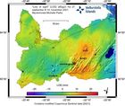
Update on Fagradalsfjall
Since 18th of September no eruptive activity has
been observed at Fagradalsfjall, but there are still small quantities of gas
measured in the atmosphere. During the eruption a deflation signal was detected around Fagradalsfjall, most likely due to magma
withdrawal from a deep reservoir which was feeding the eruption.

Joining forces in weather forecasting and climate research
The National Weather Services of Denmark, Iceland, Ireland and The Netherlands are joining forces to jointly operate a new supercomputer and to bring significant advancements to short-term weather forecasting services.
Read more
The Civil protection crisis level lowered from alert to uncertainty phase
During the past month (18th September - 18th October) no lava flow from the crater has been detected at Fagradalsfjall volcano. Out gassing is still ongoing with very low concentrations of eruptive gases. Similarly, thermal anomalies continue to be detected at lower values and greater intervals between detection's.
Read more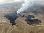
“The small eruption” in Fagradalsfjall celebrates six months
Yesterday, 19th of September marks 6 months since the beginning of the eruption. The lava flow from this eruption is thought to be relatively small compared to other eruptions in Iceland. However, due to its location and easy access for scientists and the public it has had a bigger impact and made more challenges then other eruptions.
Read more
Flood from Skaftá
The flood in Skaftá is still ongoing but the discharge has lowered significantly.
The water level in Tungulækur, which is a groundwater stream from Eldhraun, continues to rise slightly, indicating that floodwater is still spreading through the lava. Gas pollution close to the edge of the Skaftá river remains a possibility.
Read more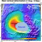
Uncertainty level declared for the ongoing uplift at Askja volcano
The National commissioner in agreement with the Police Department of the North-East Iceland declared the uncertainty level because of the ongoing uplift at Askja volcano. In the last weeks fast deformation changes have been measured in Askja, both from GPS stations and processed satellite images. The uplift has reached about 7 centimeter and that is a significant change over this temporal period.
Read more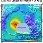
Uplift signal detected in Askja volcano
GPS observations and ground deformation maps derived from Sentinel-1 satellite data reveal that Askja volcano began inflating at the beginning of August 2021. The uplift signal is centered on the western edge of Öskjuvatn, close to Ólafsgígar. The cause of such inflation is uncertain, but most likely it is due to the inflow of new magma. Active volcanoes in Iceland, like Askja, are often characterized by periods of inactivity, lasting years to decades, with intervals of enhanced seismicity, geothermal activity, and inflation. In most cases, magmatic intrusions do not culminate into an eruption.
Read more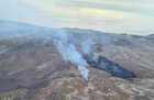
Re-evaluation needed of the size of the hazard area
Updated 03.05 12:15
The eruption in Fagradalsfjall continues
through one main crater. The active crater is the fifth fissure opening that opened in the area on the 13th of April. Since the 27th of April, the volcanic activity was characterized by continuous lava fountains, while the activity changed at around midnight on the 2nd of May, and has since been showing pulsating behaviour.
Considering these changes in activity, the size of the hazard area at the eruption site is being re-evaluated.
Read more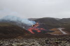
A minor eruption underway
Uptdated 29.3 at 09:30
The Civil Protection and Emergency Management's Science Board held a meeting Friday (Mars 26.) to discuss the volcanic eruption in Geldingadalir on the Reykjanes Peninsula.
A lot of data has been collected including on-site and remote measurements along with modeling work forecasting the event's possible behavior over the coming days. A report detailing the event's general status and proposals for regular monitoring will be released shortly.
Read moreThe weather in Iceland in 2020
The year 2020 was stormy. The average wind speed was remarkably high and number of windy days was unusually high.
The annual mean temperature at all stations was higher than the 1961 to 1990 mean, but below the average of the last ten years. It was relatively warmer in the East and Northeast but colder in the Southwest and West.
The year was wet in the North and East. The annual precipitation in Akureyri has never been higher since the beginning of registration in 1928.
Read more
The landslide in Seyðisfjörður is the largest landslide to have damaged an urban area in Iceland
From 15 to 18 December 2020, several landslides hit the town of Seyðisfjörður, destroying or damaging more than 10 buildings. Thankfully, there were no injuries. The largest landslide occurred on 15 December, and it ranks as the most damaging landslide to have affected an urban area in Iceland.
Read more
New article on glacier changes in Iceland over the past 130 years
An article recently published in the journal Frontiers in Earth Science on glacier changes in Iceland describes changes in the volume and mass of the Icelandic glaciers since they reached historical maximum extent at the end of the so-called Little Ice Age shortly before 1900. The results of a number of studies covering about 99% of the glacier area are summarized in the article, which is a collaborative effort of many glaciologists at several institutes that conduct measurements and research on glaciers in Iceland.
Read more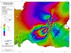
Significant ground deformation detected associated with recent earthquakes
Last week a series of earthquakes occurred on the Reykjanes Peninsula, between Fagradalsfjall and Kleifarvatn - the largest of which was a magnitude 5.6 earthquake in the vicinity of Núpshíðarháls, which occurred at 13:43 on 20th October. The maps displayed here show ground deformation associated with movement on faults during the period 16th-22nd October.
Read more
M5.6 at the Reykjanes peninsula
Seismic
activity has decreased significantly in recent days. About 180 earthquakes of
magnitude 2.2 or less were detected the last two days, for comparison, during
the first 24 hours following the 5.6 earthquake in Núpshlíðarháls, about 1700
earthquakes were detected in the area.
The Aviation Color Code for Grímsvötn changed from green to yellow
The Icelandic Met Office has changed the aviation color code for Grímsvötn volcano from green to yellow. Volcanic activity at Grímsvötn has been gradually increasing over time as indicated by several regularly monitored geophysical and geochemical parameters that are now above the known background level.
Read more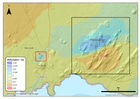
Update on the activity in the Reykjanes peninsula
Since the intense seismic swarm started in Fagradalsfjall on the 18th of July, the activity has been slowly decreasing over time. The acquisition of recent satellite images enabled mapping of new surface deformation in the area associated with the sequence of large earthquakes which occurred between the 18th and 20th of July. The satellite data processing clearly shows a deformation signal corresponding to approximately 3 centimeters of movement along a NE-SW oriented fault in the region of Fagradalsfjall.
Read more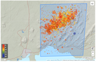
An earthquake swarm in Fagradalsfjall
On 19th July at approximately 01:30 a.m. a seismic swarm commenced in Fagradalsfjall. Over 1700 earthquakes have occurred in this region since. The largest event occurred at 23:36 yesterday evening with a magnitude (M) of 5. Two other events greater than M4 occurred early this morning at 05:46 (M4.6) and 06:23 (M4.3), respectively. In addition, 22 earthquakes greater than M3 have occurred since midnight. Felt earthquakes have been reported by local residents as far Akranes in the west and Vík in the east. The seismic swarm is still ongoing with similar intensity.
Read more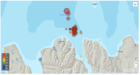
A strong earthquake swarm offshore North Iceland
A strong earthquake swarm started on 19th of June offshore North Iceland, NE of Siglufjörður. Three earthquakes above M5.0 have occurred since the swarm started. On 20th of June a M5.4 earthquake occurred at 15:05 and a M5.6 at 19:26. Both these earthquakes were located around 20 km NE of Siglufjörður. The largest earthquake of the swarm occurred on 21st of June at 19:07 and was M5.8.
Read more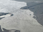
The Civil Protection Scientific Advisory Board meets to discuss the status of Grímsvötn
The meeting reviewed activity in Grímsvötn in the past months and discussed measurements made in and around Grímsvötn in early June. While seismic activity has been increasing over the past year, in June it was still lower than in the months leading up to the most recent eruptions in 2004 and 2011. Measurements of land deformation show that land continues to rise since the previous eruption with no significant changes in the last year. The biggest measurable change was that sulfur dioxide (SO2) was detected close to the last eruption site. SO2 emissions give a strong indication of magma degassing.
Read more
Evidences that Grímsvötn volcano is getting ready for the next eruption
During its active period, as it is since the eruption in 1996, Grímsvötn erupts on average each 5-10 years. The last eruption occurred in 2011 and it was a fairly large and powerful event. Between eruptions, the deformation data indicate the gradual accumulation of new magma at depth and the increased pressure in the system. In the last weeks scientists from the IMO measured SO2 in the southwest corner of the caldera in Grímsvötn, close to where the last eruptions in 2004 and 2011 took place.
Read more
Seismic activity around Mt. Þorbjörn has decreasing significantly
In the beginning of April the uplift in Þorbjörn decreased and, in the second part of the month, it stopped. The area around Þorbjörn is now most likely recovering after the large induced stress, and the injected magma is cooling down and contracting. Along with reduced deformation, seismic activity has decreasing significantly. These data indicate that the injection of magma beneath Þorbjörn has stopped and this second phase of uplift due to magma intrusion can be considered closed. This data was presented during a Scientific Advisory Board, which met on 30th of April to discuss and review the current activity in Reykjanes Peninsula.
Read more
More research is needed to decipher the on-going activity at the Reykjanes Peninsula as a whole
On Thursday the 26th of March an on-line Scientific Advisory Board meeting was held to discuss the ongoing unrest in the Reykjanes peninsula. Scientists from IMO, University of Iceland, ISOR and representatives from Civil Protection, HS-Orka, ISAVIA-ANS, and the Environment Agency of Iceland attended the meeting.
Read more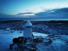
Continued inflation around Mt. Þorbjörn
From the most recent crustal deformation measurements, it is now clear that the inflation that occurred in Þorbjörn in January-February has started again. This is confirmed by both GPS and satellite data Scientists from the Icelandic Met Office, University of Iceland and ISOR met Wednesday (18.03) to review the latest data. The deformation is occurring in the same location as before, but at a slower rate. The uplift started in January and halted temporarily at the end of February. The most recent data show that since the beginning of March the uplift is about 20 mm.
Read more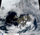
The weather in Iceland in 2019
The year 2019 was warm and the weather was mainly favorable. It was relatively warmer in the South and West but cooler in the North and East. April was exceptionally warm all over the country. It was the warmest April on record in Reykjavík, Stykkishólmur, Bolungarvík, Grímsey, Akureyri and Hveravellir.
The year was rather dry and particularly sunny in the southwestern and western part of the country. The year 2019 was the third sunniest year in Reykjavík on record. It was gloomier and wetter in the North and East. The year was one of the wettest years on record in Akureyri.
Read more
The Scientific Advisory Board meets to discuss the unrest at Mt. Thorbjörn in the Reykjanes peninsula
The data collected over the past week (including those measured by the recently installed stations) were reviewed. The new results suggest that the magma body is located at a depth of 3-5km, whereas it was previously estimated to be at 3-9km. There are indications of changing patterns in the crustal movements. The earthquake activity has decreased over the past two days, but there are still signs of a continuing inflation. Until now, the maximum deformation observed from the GPS stations is about 5 centimeters. Similar volcanic crises in the country suggest that this might be a long-term event, for which changes can occur week after week without the possibility to anticipate with certainty if the activity is resolved. During the meeting, possible scenarios that could be triggered in the event of an eruption have been also considered.
Read more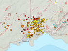
Possible magma accumulation beneath Mt. Thorbjorn on Reykjanes peninsula
An inflation has been detected since January 21st and is centred just west of Mt. Thorbjorn on Reykjanes peninsula. The inflation is unusually rapid, around 3-4 mm per day and has accumulated to 2 cm to date. It has been detected both on continuous GPS stations and in InSAR images. The inflation is most likely a sign of magma accumulation at a depth of just a few km. If magma accumulation is causing the inflation, the accumulation is very small, with the first volume estimate is around 1 million cubic meters (0,001 km3). This is the conclusion of a meeting held with the Scientific council of the Civil Protection at the IMO this morning.
Read more
Glaciologists meet in Iceland
The Icelandic Meteorological Office, the Institute of Earth Sciences, University of Iceland, and the International Glaciological Society (IGS) hosted the third IGS Nordic Branch Meeting held in Iceland in Reykholt last week. Scientists and students in glaciology and related topics presented their research results.. Most presentations were about glacier mapping, glacier geomorphology and glacier dynamics but outreach efforts about glaciers and discussions about glacier changes in a wider societal context were also on the agenda.
Read more
30th International Day for Disaster Reduction
The International Day for Disaster Risk Reduction was held the 13th of October as every year since 1989. The day was designated by the United Nations General Assembly, with the aim to promote a global culture of risk-awareness and disaster reduction, including disaster prevention, mitigation and preparedness. The day is an opportunity to create global awareness about disaster risk reduction, the progress made and to encourage further efforts to build disaster resilient communities and nations.
Read more
Glacier change sessions at this year's Arctic Circle Assembly
Changes in the area and volume of ice and snow are strong indicators of global warming and nowhere are such changes more visible than in the Arctic, where the warming rate is presently twice as high as the global average. At this year's Arctic Circle Assembly, scientists from the Icelandic Meteorological Office (IMO) led sessions and workshops on melting glaciers in the Arctic region. This is one of four topics that will be highlighted during Iceland's chairmanship of the Arctic Council in 2019–2021.
Read more
The weather in Iceland in 2018
The year 2018 was wet and relatively warm. The precipitation was well above average in most parts of the country and the number of precipitation days was considerably higher than normal both in the South and in the North. The summer months were relatively cold in the southwestern part of the country compared to the last ten years while it was warm in the northeastern part. There was exceptionally little sunshine in the southwestern part of the country during the year. The number of bright sunshine hours in Reykjavík have not been as few since 1992. June and July were particularly gloomy in the South West. The last two months of the year were warm. Wind speed was close to average
Read more
EUROVOLC is bringing the European volcanological community closer together
The European Network of Observatories and Research Infrastructures for Volcanology EUROVOLC is a H2020 Research and Innovation Project of the European Commission. It will construct an integrated and harmonized European volcanological community able to fully support, exploit and build-upon existing and emerging national and pan-European research infrastructures, including e-Infrastructures of the European Supersite volcanoes. The harmonization includes linking scientists and stakeholders and connecting still isolated volcanological infrastructures located at in situ volcano observatories (VO) and volcanological research institutions (VRIs).
Read more
100 years since Katla erupted
Today, 12 October, is the 100-year anniversary of the 1918 eruption of Katla. The volcano is considered one of the most hazardous of Iceland's 32 active volcanic systems. During the last 1100 years, Katla has erupted at least 21 times, with an average repose interval of around 50 years. The current one-hundred-year repose marks the longest period since a Katla eruption. The Katla volcanic system is located in the eastern volcanic zone. It is characterized by an 80-km-long fissure swarm and an ice-clad central volcano. The central volcano is covered by the Mýrdalsjökull ice-cap and it includes a 9 by 14 km caldera, with ice-thickness up to 700 m.
Read more
Cooperation is a must for adaptation to and mitigation of climate change
The consequences of this summer's weather have included droughts, heatwaves and wildfires, straining the society's capacity to cope with such perils. Most of the Nordic and Baltic countries have experienced the hottest summer on record, while the number of days with rain in parts of Iceland was exceptionally high. Was this summer just an exceptional freak event or is this due to climate change? And if this is due to climate change – what can be done?
Read more
Hazardous weather expected later this week
The first hazardous weather of this autumn is expected later this week which is unusually early this year. Strong northern winds are forecast from Wednesday until early Saturday morning. Precipitation associated with this weather will mostly fall on the northern part of the country in the form of rain, sleet or snow. At any point during this bad weather sleet or snowfall can be expected down to sea level.
Read more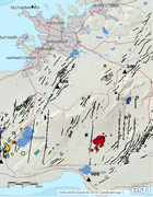
Earthquakes shake Bláfjöll ski-area
On the 13th of September at 20:17, two earthquakes of magnitude around M4 occurred, only 5 seconds apart, 6 km south of Bláfjöll mountains. Several smaller aftershocks were recorded. The earthquakes were felt widely in the capital area, and also in Ölfus and Akranes. The earthquakes are located on the tectonic plate boundary that lies eastwards along the Reykjanes peninsula where earthquakes of magnitude around M6 can occur.
Read more
The August glacial outburst - one of the larger jökulhlaups to have affected Skaftá in recent decades
The jökulhlaup peaked at Sveinstindur at around 00:00 UTC on 5 August, having reached a discharge of approximately 2,000 cubic metres per second. In terms of discharge, the August jökulhlaup is one of the larger floods to have affected Skaftá in recent decades. However, with a maximum discharge of 3,000 cubic metres per second, the October 2015 jökulhlaup remains the largest and most damaging flood to have affected Skaftá since the mid-1950s.
Read more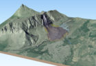
Displacements in Fagraskógarfjall for some time before the landslide fell
Sentinel-1 satellite radar images show displacement in the starting area before July 7th, when the landslide occurred according to InSAR analysis by Vincent Drouin at the University of Iceland and the National Land Survey of Iceland. The mountainside in the starting area of the landslide is different from the surrounding slopes according to an interferometric analysis of the radar images. The displacement in the last days before the landslide was at least a few centimetres. The starting area also appears to have been moving in 2017, 2016, and 2015 but at a slower rate.
Read more
Status of Öræfajökull volcano
After a series of meetings with scientists from The Icelandic Meteorological Office, The University of Iceland and Iceland Geosurvey, The Department of Civil Protection has issued the following statement.
Read more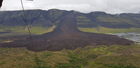
A large landslide falls in Hítardalur valley
A large landslide fell in Fagraskógarfjall mountain in Hítardalur valley, W-Iceland, in the morning of July 7th. The landslide crossed the river Hítará, damming the river and causing a lake to form above the debris tongue. The water found a new channel the next day into Tálmi, a riverbed that reconnects with Hítará a few km farther downstream.
The landslide fell from an area that showed evidence of earlier ground displacements and might be an old landslide deposit. The displaced material is a mixture of e.g. rock debris, scree from the lower part of the hillside, swamp soil and sediments from ancient lakes on the valley bottom. A preliminary estimate of the volume of the slide is 10–20 million m3. The area of the debris tongue is ca. 1,5 km2 and the debris is up to 20–30 m thick.
Read more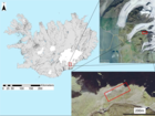
Fractures in Svínafellsheiði and a potential rockslide on Svínafellsjökull
Civil Protection advises against travel on Svínafellsjökull due to landslide danger. In particular, guided tours on the glacier are discouraged. Travellers are advised to stop only for a short while at viewpoints by the glacier tongue.
Read more
IMO and The Icelandic Civile Protection Agency reassess the status for Öræfajökull
It is close to nine months since an unrest in Öræfajökull was detected. The unrest was apparent from elevated seismicity, the development of a depression in the ice-surface (cauldron) within the caldera, and the presence of geothermal gases from a glacial river. At this time, the geothermal activity beneath Öræfajökull was assessed to be high relative to previous decades.
Read more
Glaciers in Iceland continue to retreat
The mass balance of the Icelandic glaciers has been negative since 1995 with the exception of the year 2015 when it became positive for the first time in 20 years. The mass balance in 2016 was again negative by a similar magnitude as in recent years. The mass balance of Langjökull and Hofsjökull
was again negative in 2017 whereas Vatnajökull was almost in balance. The glaciers have lost approximately 250 km3 of ice since 1995, which corresponds to ca. 7% of their total volume. Glaciers in Iceland have retreated rapidly for more than two decades and glacier downwasting is one
of the most obvious consequences of a warming climate in the country.
Read more
EUROVOLC – a networking project kick-off meeting
A group of more than 70 Earth and atmospheric scientists from 9 European countries met earlier this month in Keflavik to start their collaboration on the Horizon2020 Infrastructure project EUROVOLC. The group represents 18 partners comprising volcano research and monitoring institutions, civil protection and companies from the IT and geothermal industry.
Read more
The weather in Iceland in 2017
The year 2017 was warm in Iceland and the weather was mainly favourable. February, May, September and October were particularly warm. The East had unusually much precipitation. Heavy rainfall in the East and Southeast at the end of September resulted in extensive flooding from major rivers in the area. The last two months of the year were considerably cooler than the previous months. November was cold and the last days of December were the coldest days of the year. Wind speed was slighly lower than average.
Read more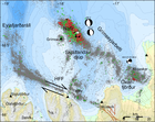
Seismic swarm east of Grímsey on the decline
The seismic swarm east of Grímsey has been on the decline for the last days. Substantial seismic activity is however still ongoing with small swarms occurring, including up to magnitude M3 earthquakes. This night, February 23, two magnitude M2.8 earthquakes where detected about 13 km north of Grímsey.
Read more
Gas concentrations in the Hofsjökull ice cave
Seismic swarm near Grímsey: update 15:00, 19 February
At 05:38 UTC this morning an earthquake of magnitude M5.2 occurred 14 km ENE of Grímsey. It was felt widely in the Northern part of the country. Five more earthquakes were detected. The earthquakes originate from the so-called Grímsey oblique rift zone in the northern Skálfandadjúp basin within the Tjörnes fracture zone.
Read more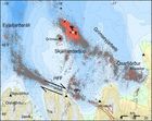
Grímsey earthquake swarm
Earthquake swarms are happening frequently in the vicinity of Grímsey. An earthquake swarm about 10-12 km North-East of Grímsey started on February 14. As of noon on February 16, over 1000 earthquakes have been detected
Read more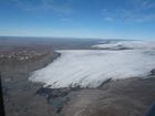
Ice cave in Hofsjökull – a warning
Ice caves are often found at glacier edges in Iceland, formed either by meltwater flow beneath the ice or by geothermal activity. News has recently been shared about a newly discovered ice cave in Blágnípujökull, where a child has collapsed due to breathing in toxic gases. The cave should not be entered without gas monitoring instruments.
Read more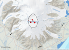
Earthquake 3.6 in the caldera of Öræfajökull
On the 9th February 2018 at 05:07, an earthquake of magnitude 3.6 occurred within the caldera of Öræfajökull volcano. Around 10 aftershocks have been recorded. The earthquake was felt by few people in the area, however most people slept through it.
Read more
IMO's Involvement in WMO's Global Cryosphere Watch
Three years ago, the World Meteorological Organization approved the implementation of the Global Cryosphere Watch as a cross-cutting mechanism to bring together international observations and research of the world's cryosphere. Its data products and services are intended to support scientific progress and environmental policy developments related to the cryosphere, including snow cover, glaciers, ice caps, permafrost, sea ice, freshwater ice and icebergs around the globe.
Read more
Final estimates of the emissions from the Holuhraun eruption based on ground-based measurements
Monitoring Öræfajökull – update 22. Dec. 2017
Real-time surveillance around Öræfajökull has been improved in the last month to better monitor the seismicity and the release of geothermal water from the caldera.
Read more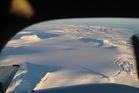
Monitoring Öræfajökull
Scientists from IMO, the Earth Sciences Institute of the University of Iceland and a representative of the Icelandic Civil Protection Authority flew over Öræfajökull Saturday 18 November to assess ice-surface changes in the volcano's caldera. They have been meeting over the weekend to analyse recent measurements and assess the situation.
Read more
A new ice-cauldron in Öræfajökull volcano
New satellite images of Öræfajökull volcano shows that a new ice-cauldron has formed within the caldera in the last week. It seems that geothermal water has been slowly released from underneath the cauldron to the glacial river of the Kvíárjökull outlet-glacier.
Read more
New seismic stations installed around Öræfajökull
Due to the recent increase in seismic activity around Öræfajökull, the monitoring level of the volcano has been potentiated. Since the end of October, three new seismic stations are streaming data into the monitoring system at IMO headquarter improving IMO's capability to detect and locate earthquakes in the area. This additional installation results in a much larger number of earthquakes of small size detected on a daily basis, and also improves the estimate of earthquakes spatial locations and their magnitudes.
Read more
IMO: Impact based color-coded warnings on web
The Meteorological Office is launching a new, color-coded warning system, thereby advancing service to the public and to stakeholders. The main changes are that the new system will be impact based and replaces an older system where only climatological thresholds were used as markers for warnings.
Read more
IMO at the Arctic Circle Assembly 2017
The Fifth Arctic Circle Assembly was held in the Harpa Conference Center in Reykjavík on October 13-15. The symposium was attended by 2000 delegates from more than 50 countries.
IMO scientists presented research and collaborative projects on climate change, Arctic hydrology and glaciology at the symposium.
Read more
International Day for Disaster Reduction – 13th of October 2017 – Home Safe Home
The flood in Múlakvísl has subsided
The glacial outburst flood in Múlakvísl has subsided. Conductivity measurements have slowly reached normal levels. Travelers are advised to show caution by the source of the river due to possible gas emissions.
Read more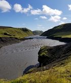
Glacial outburst flood in Múlakvísl
Glacial outburst flood in Múlakvísl river is ongoing. People are advised to stay away from the river due to gas pollution; the river is showing a dark colour and smells of sulphur.
Read more
Delivery of scientific data
IMO has received a shipment of scientific data from Dr. Richard S. Williams, Jr., geologist, which will benefit research in various fields of natural sciences in Iceland. Dr. Oddur Sigurðsson geologist was there to receive the documents, which arrived on four pallets.
Read more
Funded MS student opportunity. Dust and ash re-suspension sources
This student opportunity is a part of a collaborative research project, called “Changes in the health effects impact of aerosol particles and natural source material following volcanic eruptions”, between the University of Iceland, the Icelandic Met Office (IMO), and the UK MetOffice.
Read more
How do you view volcanoes?
The Icelandic Met Office and King's College London are carrying out a survey on views toward volcanoes. It has two aims: to investigate Icelanders' and tourists' views about the 2014–15 eruptions at Holuhraun, and to assess the role of volcanoes and volcanic activity in Iceland more generally.
Read more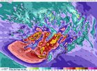
Bad weather is expected
The Icelandic Meteorological Office wants to emphasize the extremely bad weather which is expected tomorrow Friday 24th of February. Windspeed is expected to be 20 - 28 m/s (45 - 62 miles/hour) in the south and western part after noon tomorrow with strong gusts up to 40 m/s (90 miles/hour).
Read more
The Icelandic glaciers weighed from space
Mass balance measurements carried out by the Institute of Earth Sciences at the University of Iceland and the Icelandic Meteorological Office have shown that glaciers in Iceland have retreated and thinned steadily since 1995. The volume of the glaciers has been reduced by approximately 10 km³ per year on average. The mass loss of the glaciers causes perturbations in the Earth's gravity field near Iceland that are detected by sensitive instruments on board of German/American GRACE satellites.
Read more
The weather in Iceland in 2016
The year 2016 was very warm in Iceland. It was the warmest year on record in all stations in North-West part of Iceland and one of the warmest in other parts of the country. During the first two months of the year temperature were close to long-term means, but the last three months of the year were particularly warm. Wind speed was slightly lower than average. During late winter to mid-summer conditions were rather dry, but the autumn was very wet, especially in the southern part of Iceland
Read more
Reporting floods well appreciated
With the foreword that safety is most important, reporting on flood events is welcome. Apologies; the web form is still only available in Icelandic but fairly self-explanatory. Please have a go and comment in English, that would be well appreciated.
Read more
Severe gale or storm
South and southeast severe gale or storm has been forecast in most of Iceland until Thursday morning. Northern Snæfellsnes has had the strongest winds. This evening, winds are increasing again. Storm or gale from the southeast and then the south, is forecast for the West and the North with wind gusts over 40 m/s. Winds will decrease in the West during the night but in the North not until morning. Rising stream- and river levels are likely in many regions. Travellers are cautioned against fording. After safe arrival, please report on observed flooding.
Update on the weather forecast and flood conditions
Following heavy rainfall overnight, stream and river levels remain high in the south.
Streams and rivers around Eyjafjallajökull, Mýrdalsjökull, and southern parts of Vatnajökull are very high. Further heavy rainfall is forecast for this region, so river levels will increase further until Thursday evening. In Selfoss, the river Ölfusá will continue to increase until late on Friday or early on Saturday.
Read more
On the weather forecast and the flood conditions
Flooding is occurring on Barðaströnd, Snæfellsness, and at the Mýrdalsjökull ice-cap. Note that river levels around Mýrdalsjökull will increase further overnight and on Thursday.
Flood conditions are expected in streams and rivers from Mýrdalsjökull to Hornafjörður. Travellers are urged to avoid all watercourses in the above-mentioned regions in the coming days.
Warning due to heavy rainfall and increased river levels
47th Nordic Seismology Seminar held in Reykjavík
The 47th Nordic Seismology Seminar takes place 11 - 13 October 2016. The seminar covers a wide range of topics related to seismological research, such as automatic detection of earthquakes, improving methodology in data analysis, hazard assessment and engineering seismology, as well as structural studies of the earth's crust and upper mantle. As this year's seminar takes place in Iceland, a special focus will also be on volcano seismology, magma tracking in the crust and eruption early warning.
Read more
Seismic swarm at Katla
An intense seismic swarm is ongoing since yesterday morning 29 September at Katla volcano. An intense pulse started today at 12:02 (30 September) with several earthquakes around magnitude 3 or larger. No seismic tremor has been detected. Due to the unusually high level of unrest at the Katla volcano we rise the aviation colour code from green to yellow. The volcano continues to be monitored closely.
Read more
Dyngjujökull station
In June 2016 a weather station was established on the upper reaches of Dyngjujökull, about 10 km north of the Grimsvötn caldera, at 1689 m above sea level.
A seismometer has been in operation by the IMO at the site since the
autumn of 2014 and the main purpose of the new weather station is to monitor conditions at this important location in the network, amongst the
volcanoes of Vatnajökull.
Heavy rain is forecast
Heavy rainfall in the East fjords and heavy rain is forecast for the North. River levels are elevated due to rain, with the possibility of mud flows.
Heavy rain and discharge is forecast for Northern Iceland. Flash flows cannot be excluded.
Checking on drainage near buildings is encouraged. Read more
Minor jökulhlaup in Skaftá
8.9.2016: The level of Skaftá river has risen significantly. This suggests that a glacial outburst flood is in progress.
Hydrogen sulphide is released from the floodwater as it drains from the ice-cap and H2S is particularly potent at the ice margin (poisonous levels). Travellers must stay away from the edges of Skaftárjökull and Tungnaárjökull while the flood occurs.
Crevasses will develop rapidly around the ice cauldron, so travellers on Vatnajökull should stay away from the region.
Read more
Katla and Mýrdalsjökull
Since mid-June, there has been heightened earthquake activity in the Katla caldera. Summertime increases in caldera seismicity are an almost annual occurrence at Katla, often associated with the drainage of geothermal meltwater in the form of minor floods in glacial rivers from Mýrdalsjökull
These are not necessarily precursors to an imminent volcanic eruption.
Similar unrest has taken place at Katla several times since the 1950s
without culminating in an explosive eruption.
Travellers are urged to not spend time close to Múlakvísl, especially the upper reaches of the river, as measurements near to the source show unhealthy levels of hydrogen sulphide, signifying high concentrations of geothermal fluids.
Read more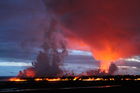
Nordic Seismology Seminar in Iceland
The 47th Nordic Seismology Seminar will be held in Reykjavík, 11-13 October 2016.
The meeting will commence on Tuesday in the early afternoon and last until Thursday evening.
Those who are interested in attending, are encouraged to apply for participation.
On the Bárðarbunga gradual caldera collapse
The eruption in Holuhraun in central Iceland in 2014 - 2015 was the largest seen in Iceland since 1783. The ice-filled caldera of Bárðarbunga central volcano collapsed during the eruption as 1.9 km³ of magma flowed laterally from a magma reservoir under the volcano. Eruptions of this type are not common. This caldera collapse is the first where it has been possible to carry out detailed observations during the events. Unique data was obtained that threw new light on the mechanism of caldera collapses and their interaction with the associated eruptions. A large team of scientists has analyzed the data from Bárðarbunga and published the results in the journal Science.
Read more
On the micro-earthquake activity at Mýrdalsjökull
Seismic activity in the Katla caldera has increased in recent weeks, but this is not unusual during the summertime. The activity is associated with drainage of meltwater from several known ice-cauldrons due to hydrothermal activity. Four small floods have been detected and a smell of sulfur has been reported from several locations; these events combined with higher conductivity indicate presence of geothermal water. Measurements around Katla are not detecting signs of increased ground deformation or seismic tremor, both of which would be indicators of magma movement. Experts at IMO assess that an eruption is not imminent, however, a hazardous flood cannot be ruled out.
Read more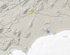
Warning to travellers on the Laugavegur trek
Travellers on “Laugavegur” in South Iceland, the popular highland trek from Landmannalaugar to Þórsmörk, are warned that water levels have risen in river Bláfjallakvísl, north of Mýrdalsjökull.
Hikers are advised not to attempt to cross the river, as waist-high water levels have been reported. The water discharge is expected to continue increasing over the week-end due to warm weather.
Read more
Monitoring of Hekla
Of the thirty active volcanic systems in Iceland, Hekla is one of the most active and potentially dangerous. In this summary we outline the types of hazards that might occur during the next Hekla eruption, and how the Icelandic Meteorological Office is monitoring the region.
Read more
Activity in the Bárðarbunga system since the end of the eruption
The Civil Protection Scientific Advisory Board met June 23rd, in order to review new data on the volcano Bárðarbunga.
The most probable explanation for ground deformation and earthquake activity in the area, is inflow of magma at about 10 to 15 km of depth below Bárðarbunga. There are no indications of magma collecting at shallower depths. This process is common in the aftermath of volcanic eruptions.
Probably meltwater will start collecting under the cauldrons along the caldera rim or within the caldera itself. Therefore it is imperative to monitor the evolution of the cauldrons, the seismic activity, ground deformation, geothermal activity and gas emissions in Bárðarbunga.
Read more
A minor glacial outburst flood in Skaftá
Within recent days, the level of the Skaftá river at Sveinstindur has risen slowly. Additionally electrical conductivity readings from the same location have increased. These observations suggest that a glacial outburst flood (jökulhlaup) is in progress.
The flood is not expected to cause any downstream disruption. However, precaution is needed at the ice margin and around the ice cauldron.
Read more
Supercomputer in Iceland
In order to fulfill environmental requirements, the DMI approached the IMO for a cooperation on a supercomputer. In 2014 a contract was signed and now the supercomputer is in full operation at IMO's premises. The cooperation is based on a long term, consistent relationship. DMI owns and runs the supercomputer while IMO operates the site infrastructure and costs are shared. This article gives the basic facts of the project and provides links to photos from the inauguration as well as a recording of the lectures.
Read more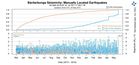
On the Bárðarbunga earthquakes
Seismic measurements around the Bárðarbunga volcano show that the seismic moment release on the caldera ring fault has been gradually increasing since mid September 2015. This means that stronger earthquakes than before are detected in the last months. Despite of the increasing activity, there are currently no signs of volcanic tremor.
Read more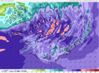
Warning - storm in Iceland
Icelandic Met. Office issues warning for bad weather conditions in Iceland tomorrow, Saturday 12th of March.
Read more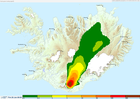
A FUTUREVOLC exercise
Over three days at the end of January 2016 all 26 FutureVolc partners, together with additional Stakeholders, were involved in responding to an evolving eruption scenario. The exercise was a great test of the new instrumentation and procedures introduced by FutureVolc.
Read more
Storm in Iceland
Strong gale or storm with moderate or extreme precipitation first in the southern part. Moderating in the southwestern parts by evening, in the southeast parts early morning, in the north and east tomorrow morning, but not until tomorrow afternoon in the northwest.
Read more
The weather in Iceland 2015
The weather in 2015 was considered unfavourable, except the autumn. The winter was dominated by a series of heavy windstorms, often with snow and rain. In late April, cold and northerly winds set in and persisted until the end of August, often with heavy precipitation in the Northeast and East, but in the Southwest the weather was slightly more favourable. The autumn (September to November) was the most favourable part of the year. The year 2015 was the coldest in Iceland since 2000, but this period has generally been abnormally warm so the average temperature was close to the 1961-1990 mean. In most parts of the country, the precipitation was well above normal.
Read more
Safetravel in winter
Increasingly, tourists come in winter to enjoy the beauty of the northern lights. Safety while travelling is always crucial, especially in winter conditions.
The web-site Safetravel is run by ICE-SAR in order to minimize the risk of accidents in travelling and tourism in Iceland.
Thorough information on safe travelling can be found there. The 112 Iceland app can be downloaded and your travel plan can be left in safe hands before you go. Additionally, a personal location beacon can be rented at two pick-up places.
Read more
Storm in the North and calmer in the East
The low is now north of Iceland and wind has started to decrease in the east. Storm in the North at noon or after noon.
Southwest 18 - 28 and wintry showers by noon, strongest wind in the north. Decreasing winds late afternoon. Mostly dry in the northeast tonight. South and southeast 8 - 15 m/s tonight and tomorrow, snow or snow showers but mostly dry in the north. Temperature 0 to 5 °C today but colder tomorrow.
Read more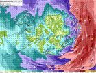
Warning due to violent storm
Violent storms, or even hurricane force winds, are forecast in the eastern parts of the country tonight and during the morning, first in the southeastern parts.
A low pressure of 958 mb is rapidly deepening far to the south of Iceland, moving fast in a northerly direction. Air pressure of 934 mb is forecast soon after midnight and 933 mb in the northeast at 7:00 UTC tomorrow morning.
Boat owners should secure their boats due to high tides after midnight in the East. Also, the public is advised to fasten loose objects outside.
Floods in the Southeast and East fjords
Due to precipitation and melting, increased water levels are prevalent in the Southeast and in the Eastfjords. Rivers Geithellnaá and Fossá in the fjord Berufjörður are flooding. Their discharge has grown by a factor of ten within 24 hours. River discharge will continue to rise in the Southeast and towns may experience flooding streets. Snow avalanches with high water content have occurred and mudflows may occur.
Read more
Weather warning – hurricane force winds
Violent storm or hurricane-force winds are expected throughout most of the country tomorrow afternoon and tomorrow evening. The magnitude of the approaching storm is so great that such conditions occur only every 10 to 20 years.
Significant snowfall will accompany the beginning of the storm, resulting in blowing snow and little or no visibility. According to the latest forecast, the oncoming violent storm tomorrow, Monday, will be far more severe than the storms in recent days.
Read more
Weather warning - violent storm
A strong gale warning is in effect in Iceland this afternoon and tomorrow. Violent storm is expected in the southernmost part and in the southeast between 15:00 and 20:00 this afternoon.
Travelling conditions in the south and southeast are expected to be extremely poor.
Southwest Iceland, including the capital area, will have near gale wind and blowing snow along with intermittent light snow.
Overnight and tomorrow the risk of avalanches will increase in the Westfjords and in North-Iceland.
Read more
Violent storm expected in the South
A strong gale warning (average windspeed above 20 m/s) is effect in Iceland today, Friday 4th December, and a violent storm (average wind speed, above 28 m/s) is expected in the southern most part as well as in the southeast.
Travelling conditions in the south and southeast are extremely poor on Friday.
On Saturday a strong gale with snow and decreased visibility is expected in the northern part.
Read more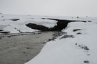
Hofsjökull ice cap gains mass
All ice caps in Iceland have been retreating rapidly and losing volume since 1995, but in 2015 the Hofsjökull ice cap in the central highlands displayed positive mass balance.
A positive mass balance on Hofsjökull in this year did not come as a surprise, given the high levels of snowfall in Iceland during the winter and low melting rates due to a cool summer.
It would be premature to assume that this signals a reversal of climate conditions in Iceland, because single cool years sometimes occur within warm periods. The year 2015 is very likely to become the warmest year recorded on Earth since the start of instrumental observations.
Read more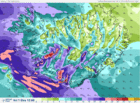
Warning due to a strong gale
Increasing easterly winds tonight in the southwest, including the capital area.
Early tomorrow morning, decreased visibility due to blowing snow, both in the capital region as well as en route to the KEF airport. Before noon, winds increase with large amounts of snowfall.
Increasing winds and precipitation are expected in Eastern Iceland tomorrow afternoon, with deteriorating travel conditions.
Read more
The weather app improved
Weather forecasts and the current weather condition can be checked through an improved weather app provided by IMO.
Forecasts are now provided for each hour and the meteograms are available again.
Location is detected if GPS on; alerts issued by the Met Office appear automatically during the day and a personal weather watch can be arranged.
An interactive weather map shows weather observations at any station in the country.
Read more
The outflow of the jökulhlaup at the terminus of Skaftárjökull
A field expedition to Skaftárjökull on Thursday 1 October revealed that the jökulhlaup had burst through the glacier at several locations, see photos and a video in another article.
Dark bands of debris extended down where the jökulhlaup had flowed. Ice fragments were scattered over the surface of the glacier.
The flood waters appear to have flowed through the glacier for some time and concentrated in one or more circular channels that the flow melted through the glacier.
Jökulhlaup in Skaftá - progress
The measured discharge at Sveinstindur peaked around 2:00 this morning, showing almost 2100 m³/s. True discharge may have been considerably greater.
The discharge at Eldvatn near Ásar peaked around 13:00 showing discharge of approximately 2200 m³/s. The area outside the main water channel will be flooded for coming days.
Three gas sensors have been installed, in order to monitor the gas released from the glacial outburst occurring along the Skaftá river.
Read more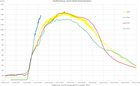
Possibly the largest jökulhlaup
The rate of discharge increase at Sveinstindur is the highest observed since the station was established in 1971. From initial observations, the ongoing jökulhlaup could be the largest to have occurred from the Skaftá cauldrons. The jökulhlaup will likely reach maximum discharge in the lower reaches of Skaftárdalur during the early hours of Saturday, 3 October.
Localised flooding should be expected. Gas will reach poisonous levels at the edges of Skaftárjökull, Tungnaárjökull and Síðujökull. Crevasses will develop rapidly around the ice cauldron, including the lower part of Skaftárjökull and Tungnárjökull.
Ice surface lowering - striking graph
Floodwater continues to drain from the eastern Skaftá ice-cauldron. The latest GPS measurements show that the rate of ice-surface lowering continues to increase. This can now be observed on the web on a graph that updates every five minutes.
Localised flooding should be expected on the lower part of Skaftá late on Thursday, lasting through the weekend, and possibly at Hverfisfljót bridge. Gas will reach poisonous levels at the edges of Skaftárjökull, Tungnaárjökull and Síðujökull. Crevasses will develop rapidly around the ice cauldron, including the lower part of Skaftárjökull and Tungnárjökull.
Glacial outburst flood probably in progress
Various observations signify that a glacial outburst flood (jökulhlaup) is in progress in Skaftá river; including the water level at Sveinstindur and electrical conductivity readings. Data from the GPS-station in the Eastern Skaftá cauldron in Vatnajökull is also being closely monitored, the last jökulhlaup from there having occurred in 2010. Further information will be given later this afternoon.
Read more
Articles on Bárðarbunga and Holuhraun
In early April 2015 the natural hazards banner was removed from the header of IMO‘s website. The short-cuts can now be found in an overview article which contains all the links on these issues provided by IMO since August 2014.
Gas emission from the lava field is still being monitored by continuous measurements around Holuhraun. The gas dispersion model is still operational but text forecasts are no longer made.
Seismic monitoring is as thorough as before and on any significant increase, the natural hazards banner will be presented in the header of all IMO‘s web-pages again.
Heavy rainfall and increased river discharge
A low is approaching Iceland Saturday morning and high precipitation levels are forecast until early Sunday morning for much of S- and W-Iceland. Heavy rainfall is expected in the southeastern part of the country, leading to increased discharge in rivers and creeks in lowland and highland regions, which can trigger landslides. Special caution is required when attempting to cross unbridged rivers under these conditions.
Read more
Web downtime due to maintenance
Due to the renovation of our electricity systems, IMO's web will be inaccessible this afternoon and until evening. Expected downtime is from 3:30 PM to 8:00 PM.
We apologize for any inconvenience this may cause. Warning and notes will be published at our Facebook page if necessary.
Warning due to intense rainfall
Intense rainfall is expected in south-east Iceland and the Snæfellsnes peninsula with rising river levels from Eyjafjallajökull to Djúpivogur in the East Fjords. In mountainous coastal regions, intense rainfall could trigger hazardous landslides and mudflows without warning.
All travel plans should be made considering the latest weather warnings. Travellers are advised to stay away from all watercourses and strongly advised against crossing streams and rivers in the above-mentioned regions.
Read more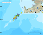
Earthquake swarm diminished and AVCC code lowered
IMO has lowered the aviation colour code at Eldey volcano from yellow to green. The seismic swarm on the Reykjanes ridge has significantly diminished in intensity and there are no direct signs of magma movements in the shallow crust. Water samples collected on 1 July do not show any spatial anomalies in pH or electric conductivity around the area of the seismic swarm.

Slight web hitch possible
Because of maintenance work, some slight hitch in our web services is possible today and tomorrow. The users of vedur.is and en.vedur.is might experience hectic appearance of web pages and the downloading of data will be slower than usually. This maintenance is part of a project which will improve IMO's services in the future.
Read more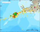
The earthquake swarm on Reykjanes ridge
As said earlier, an intense earthquake swarm started on 30 June near Geirfuglasker on the Reykjanes Ridge. The first burst of activity calmed down around midnight and activity is since occurring in pulses. Similar swarms have been recorded in previous years and have generally lasted up to a couple of days without resulting in an observable eruption. Based on the evidence that the current seismicity is well above the normal background condition, it has been decided to raise the aviation color code for Eldey volcano from green to yellow.
Read more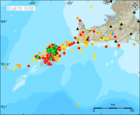
Earthquake swarm on the Reykjanes ridge
An earthquake swarm started yesterday at 21:00 on the Reykjanes ridge, about 30 km southwest of the tip of Reykjanes peninsula. The strongest earthquake so far is an M5.0 at 02:25 and it was well felt on the peninsula and in the capital area, as well as on a ship around 10 km away from the epicenter. The first burst of activity lasted until midnight. Since then, activity has occurred in pulses with two to three hours in between.
Read more
Warning – strong wind and sharp gusts in the South
Strong wind and sharp gusts are expected by Eyjafjöll, in Mýrdalur and in Öræfi by late evening tonight (Thursday) and tomorrow. Wind will not decrease until late tomorrow evening (Friday). In these conditions, trailers, house trailers etc. might cause trouble on the road. Travellers with such equipment are advised not to drive through these areas until winds have calmed down (Friday night or Saturday morning).
Read more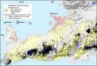
Increased seismic activity between Krýsuvík and Ölfus
In recent weeks, increased seismic activity has been detected on the Reykjanes peninsula. Historic recordings show that earthquakes in that region can be up to M6.5. The last earthquakes of M>6 were in 1929 and 1968. Both of these events caused no major damage in the capital area. In modern times, however, urban settlements have spread closer to historically active earthquake faults.
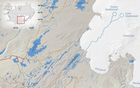
Warning - glacial outburst flood at Skaftá
Flood conditions are expected in Skaftá over the next two to three days. Some flooding of unpaved roads close to Skaftá is possible. Hydrogen sulphide is released from the floodwater as it drains from the Vatnajökull ice-cap. The gas is particularly potent at the ice margin, where concentrations will reach poisonous levels. Travellers must stay away from the edges of Skaftárjökull, Tungnaárjökull and Síðujökull while the flood occurs. Crevasses will develop rapidly around the ice cauldron, so travellers on Vatnajökull should stay away from the region, including the lower part of Skaftárjökull and Tungnaárjökull, where floodwater could burst through the surface.
Read more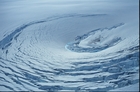
Final Conference of the SVALI project
The Final Conference of the Nordic Center of Excellence SVALI was held 4-5 June at the Ilulissat Climate Days in Greenland, focusing on the topics of changes of the Arctic and North-Atlantic land ice as well as glacier and ice cap changes, process understanding and impacts on sea level.
The Ilulissat Climate Days especially address recent, ongoing and future changes in the ice in and around Greenland, with a special focus on the effects for the Greenland society.
Read more
Mains transformer upgraded
Wednesday 3 June 2015, Reykjavík Energy will upgrade the transformer of the mains for Bústaðavegur 7, Bústaðavegur 9 and Útskálar buildings, which will run on diesel generators‘ electricity meanwhile. This upgrade will start at 8 o'clock and the work can take up to 10 hours. An effort will be made to prevent any disruption to IMO‘s services.
Read more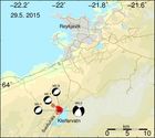
Earthquake sequence at Kleifarvatn
On 29 May at 13:10 an earthquake of magnitude 4.0 occurred under the northern part of Sveifluháls, close to lake Kleifarvatn on the Reykjanes peninsula. It was widely felt in the capital area and in Akranes.
Another magnitude 3.1 event was measured earlier the same day at 11:58 at the same location. Hypocenter depths of the earthquakes were around 3-4 km.
Read more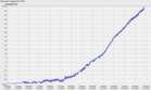
A minor jökulhlaup in river Gígjukvísl
A minor glacial outburst flood (jökulhlaup) is occurring in the river Gígjukvísl on Skeiðarársandur. The flood, which originates from subglacial lake Grímsvötn, became apparent on 6 May when the level of Gígjukvísl began to rise steadily.
Potentially hazardous levels of hydrogen sulphide gas could be present at the location where floodwater bursts from Skeiðarárjökull. In the immediate vicinity of the outlet, gas concentrations could be high enough to cause respiratory problems and even damage to eyesight. For travellers on Skeiðarársandur, the ongoing flood poses no hazards.
Read more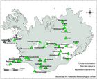
Bárðarbunga AVCC now green
IMO has changed the Aviation Colour Code for Bárðarbunga volcano from yellow to GREEN, as from 24 April 2015.
This decision has been taken in light of recent seismic and geodetic data from around the volcano, in addition to other measurements such as satellite-based thermal observations and radar-profiling flights.
Bárðarbunga continues to be monitored closely and any significant change in the volcano's state will be reported immediately.
Read more
The weather in Iceland 2014
The year 2014 was very warm, precipitation was abundant and the sunshine duration during most of the summer was considerably below average.
In spite of the high temperatures the weather was changeable and often dull.
The first months of the year were especially wet in the North and East and the weather was difficult. In the west it was very dry at the same time with favourable weather conditions.
The summer was warm and considered fine in the North and East but in the south it was very wet and dull.
The autumn was fine, November extraordinarily warm, but the year ended with an unruly and rather cold December.
Read more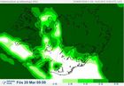
The solar eclipse 20 March
Friday 20 March 2015, an almost total solar eclipse will be seen from Iceland, such as has not been seen for 61 years. And it so happens, that this time, it will occur on equinox.
Clouds may impede the view. Check IMO's cloud cover forecasts, where white means clear skies, and adjust the scale underneath the map for correct timing (roughly between 08:30 and 10:40). The tabs above the map will show more selective forecasts for low, high or middle clouds.
People are strongly advised against looking at the sun without proper precaution. Even a glimpse towards the sun might cause irretrievable damage to the eyes.
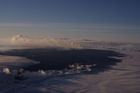
The eruption has come to an end
The volcanic eruption in Holuhraun has come to an END. For the first time, no glow was seen in a flight 27 Feb.
Volcanic gas can still get dispersed all over the country; emission has not ended.
The lava field is now 85 km². The average thickness is at least 10 - 14 m (max 40 m) and the volume is about 1.4 km³.
The maximum subsidence of the caldera is at least 61 m and the rate was only 5 cm/day last week, compared to tens of centimetres earlier. The volume of the subsidence is 1.7 - 1.8 km³.
Conditions on the eruptive site are still dangerous. Gas emissions at the eruption site and from the lava field are still life threatening.
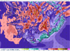
Severe weather, Saturday 14 March
A violent storm with hurricane-force wind gusts will occur tomorrow, Saturday 14 March. Intense rain and snow-melt is expected in the south- and southeast. Rising river levels are expected.
National warnings for wind, rain, hazardous flash floods, wet snow avalanches, slush flows and landslides are in effect.
The same weather warnings apply to Reykjavík and the surrounding area. Travel is exceptionally hazardous and people are advised to remain indoors; non-essential travel should be avoided.
Intense rainfall - possible floods and flows
Intense rainfall is expected in the south and south-east of the country, especially around Mýrdalsjökull and south of Vatnajökull, as well as nearby mountainous areas. A warning was issued yesterday.
Rapid melting of recently fallen snow could result in river and stream floods, slush flows, and, possibly, mud flows. Such extreme conditions occur every few years, so special care must be taken to avoid possible hazards.
Read more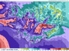
Gale increasing
A strong gale or severe gale warning (average wind velocity 20 to 28 m/s) is in effect for all parts of Iceland today.
Bad weather is expected late noon until night. Visibility will be poor because of snow and drifting snow. Bad travelling weather in mountain roads and even closed roads. The weather passes over the South and West parts in the evening, but near midnight in the east part.
Read more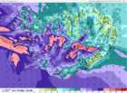
Warning - strong or severe gale
Bad weather is expected from noon tomorrow until late tomorrow evening and night. Visibility will be greatly diminished due to snow and blowing snow and travelling across mountain roads will be challenging, perhaps impossible. The weather will pass in the southwest between 19 and 21 UTC, but after midnight in the North and East.
Read more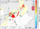
Comparison of displacement velocities for different time periods
The Bárðarbunga seismic- and volcanic events provide multitude of data, supporting various research.
Now, displacement velocities of GPS stations in the vicinity of Bárðarbunga over the past month, are compared with their displacement velocities from 21 September until today.
The date 21 September is chosen because by then, displacement velocities related to the propagation of the dyke have become negligible and large displacement signals around Bárðarbunga are solely due to the subsidence of the caldera.
Read more
Warning - severe gale today
Bad weather is expected with poor travel conditions today and in the West tomorrow.
Increasing east wind with snow in the south- and west parts, but later sleet or rain by the coast, 18 to 28 m/s in the afternoon, strongest by the south coast. Lighter wind and light precipitation in the north and east parts at first, then 18 to 23 there and snow or blowing snow.
Considerably decreasing wind and precipitation by evening and tonight, but still strong gale in Vestfirðir. North 20 to 30 m/s and snow or snow showers in the western part tomorrow, strongest wind in Vestfirðir.
Read more
Warning - high winds
Bad weather is expected with poor travel conditions Wednesday 25 Feb., first in the south and west.
Northeast wind, 5 to 13 m/s and snow showers or some snow in most parts. Temperatures from 0 to minus 8 °C, coldest in the north. Becoming southeast and east 20 to 28 m/s in the south and west with snow or sleet, but later rain in the southernmost part. Lighter and mostly dry in the north and east, but increasing wind there in the afternoon with snow.
Temperatures slightly below zero, temperature near zero degrees in the south in the afternoon. Decreasing wind and precipitation tomorrow evening and night, least though in Vestfirðir, the West fjords.
Read more
Warning - severe storm in the South on Sunday
Strong wind gusts (over 40 m/s) are expected near mountains in the south and southwest tonight and tomorrow. The worst weather will be in the South.
Strong winds with snow and snowdrift means that visibility will be little to none, and travelling is discouraged.
Even though there will be less precipitation in other parts, the wind will be enough to to move loose snow which is there already and form snowdrift and delay or inhibit travel.
On Monday it looks like strong northerly wind, and it does not look like the wind will moderate until Tuesday.
Read more
Warning against heavy rainfall
Heavy rainfall and mild conditions are forecast for west, south-west, south, and south-east Iceland on Saturday 14 February, lasting until late afternoon on Sunday.
It is advised to check drainage and keep it clear of leaves, rubbish, ice etc. in order to prevent water damage.
The southerlies that cause these changes may reach storm conditions (over 20 m/s) in West- and Northwest Iceland when rushing down from the mountains. They may also give rise to very sharp gusts of wind.
Rising stream- and river levels are expected on the Snæfellsnes peninsula, around the Eyjafjallajökull and Mýrdalsjökull ice caps, and south of the Vatnajökull ice-cap. Travellers are cautioned against fording rivers in these regions.
New equipment at Holuhraun
A MultiGAS gas measuring instrument and a weather station were installed near the Holuhraun eruption 22 January 2015.
Both instruments transmit data to IMO which will be used for monitoring the eruption. The data base which builds up, will help with forecasts of future eruptive activity.
The MultiGAS instrument is part of a collaboration with the University of Palermo, thanks to the FutureVolc project. The weather station is part of a collaboration with the British Geological Survey.
Read more
An ice surge at Jökulsá á Fjöllum
An ice surge is occurring on Jökulsá á Fjöllum at Grímsstaðir. The ice that had formed on the banks and the surface of the river has broken into many fragments, creating an icy, slow moving mixture. Water is beginning to seep over the main road, west of the bridge.
In addition to this news article, see a photo gallery from the bridge including updated satellite images and aerial photos from a surveillance flight.
As the break-up of snow and ice continues, it is possible that water could continue to leak across the road. If the discharge of Jökulsá á Fjöllum increases due to snow-melt or rainfall, then the level of flooding could be greater.
Read more
Monitoring device rescued from the lava
One of IMO's SO2 monitoring devices, which had been trapped by the Holuhraun lava flow since last year, was rescued on Saturday 10 January by staff from the Institute of Earth Sciences and Reykjavik Helicopters.
This instrument is part of the FutureVolc collaboration with IMO's partners at Chalmers University of Technology and the University of Applied Sciences in Dusseldorf.
Read more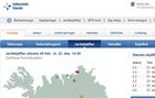
Warning banners removed
With enhanced SO2 monitoring capabilities and regular dispersal forecasts IMO has decided to remove the yellow warning ribbon from the header of IMO's web.
The gas dispersal forecasts will still be available and monitoring of the SO2 release and dispersal will not decrease. The warning ribbon will be used if the values of SO2 are forecasted or measured to exceed the public safety limits for longer periods of time.
IMO has also decided to remove the warning for an eruption in Holuhraun, as there have not been any significant changes. The eruption is still as closely monitored as ever. Should there be any significant changes new warnings will be issued.
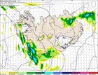
Festive forecast
Fine weather is forecast on New Year's Eve and New Year‘s Day in all of Iceland.
Tomorrow morning, winds will be southerly in most of the country, 8-13 m/s with sleet or intermittent rain, but in the afternoon lighter winds are forecast in northern and eastern Iceland with brighter skies.
At midnight, winds will be calm everywhere although light snow showers are expected in the south and the west. Temperatures will be close to zero.
New Year‘s Day has also a fine weather forecast; slow wind, scattered hail and 0°C. Some snow is, however, expected at the northern coast part of the day.
Snow avalanche stopped by a catching dam
A snow avalanche released from the mountain slope above the village of Siglufjörður in N-Iceland was stopped by a protective dam, most likely on 12 December.
The avalanche started in a gully below a shelf in the middle of the mountainside at approximately 340 m a.s.l.
The avalanche hit the dam along a more than 50 m distance and left rocks and branches that it picked up on its way on the damside. It was approximately 2 m short of reaching the top of the dam and threw some snow clods over the dam crown.
It is likely that the avalanche would have reached close to or hit the uppermost houses if it had not been stopped by the dam.
Read more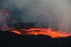
The segmented dyke intrusion explained
Advanced online publication in Nature reports research by an international team of geoscientists on the formation of the intrusive dyke which extends 45 km in the subsurface from the Bárðarbunga central volcano to the eruptive site in Holuhraun. There, the eruption has been ongoing for more than 100 days.
The paper in Nature reports how the dyke formed mostly over two weeks prior to the onset of main eruptive activity. A model for the dyke also explains unusual and varying direction of dyke segments, that relate to interaction of topography and stresses in the ground caused by divergent plate movements in Iceland.
The team includes 37 scientists from the University of Iceland, the Icelandic Meteorological Office and eight universities in other countries. This is part of the research project FUTUREVOLC funded by the European Union.
Read more
What is Bárðarbunga?
There are about 30 known central volcanoes, or volcanic systems, in Iceland. Bárðarbunga, the second highest mountain of Iceland. A caldera in the volcano's crown is covered with approximately 850 m thick glacial ice. Eruptions can occur in the caldera, on the sides or in the fissure swarms. Because of the current seismic activity in northwestern Vatnajökull, IMO has been allowed to publish the chapter Bárðarbunga System, an extract from a much larger work in progress.
Read more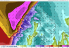
Gale force wind in Westfjords
Very high northeasterly winds (25-35 m/s) are forecasted in the northern Westfjords this afternoon, 9 December.
At Hornstrandir and by Ísafjarðardjúp, including habited areas, the weather will worsen considerably between 2 – 3 PM with these high winds and snow.
This evening and tonight northeasterly winds 20-28 m/s are forecasted with snow and hail in all the Westfjords. Tomorrow morning, 10 December, winds will calm down.
See also warning of high tide.
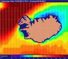
Warning - high tides in the Westfjords
High seas are expected off the shores of the Westfjords on Tuesday evening 9 Dec. and Wednesday morning (10 Dec.).
Because of the tide, a warning is issued; waves and surf on the relevant coasts might become unsually strong. Waves over 12 m from the north and northeast are forecasted.
Warning for Sunday and Monday
IMO draws attention to the weather forecast of strong or whole gale for this coming Sunday and Monday. Flooding may occur.
Westerly and southwesterly winds, 20-30 m/s, can be expected; in the southern part of Iceland on Sunday evening but in the northern part early on Monday morning. Cooler air will follow the westerly winds, with precipitation changing from rain to snow showers at sea level. Average wind speeds may be expected to exceed 28 m/s, which is whole gale according to the Beaufort wind scale. Wind gusts can be expected to reach 50 m/s, especially to the north and east of mountains (the leeside). This results in very poor travelling conditions.
A warning due to flooding has also been issued. There will be heavy rain and fording rivers may become dangerous in certain areas.
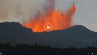
The FutureVolc project and the eruption on National Geographic
National Geographic published a web article recently on the eruption in Iceland, how its timing contributes to the FutureVolc project and how, thanks to new instruments deployed by FutureVolc, this is one of the best monitored eruptions in history.
There is a video from the field and interviews with the scientists. The reasons why Iceland was chosen to lead the international project are given. The importance of open data is discussed and two data products developed at the Icelandic Met Office are shown.
Read more
Warning – the first real snow of autumn in northern Iceland
The Icelandic Met Office warns against the first real snow of autumn in northern Iceland. Northerly wind, strong gale force, is expected with snowfall in the northern part. In the North travelling is not recommended, neither on Monday nor Tuesday, especially not in cars which have not been prepared for winter driving.
Read more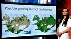
The weather in Iceland in 2050
The United Nations' Climate Week NYC was held in New York. It is the collaborative space for all related events in support of the UN Climate Summit. Iceland's representative on the climate week was Birta Líf Kristinsdóttir, Icelandic Met Office, one of eleven TV meteorologists who were asked to make a weather forecast for their own country in 2050 based on the visions of the newest IPCC report. These weather forecasts of the future are presented as a set of videos, published one per day until the summit. The Icelandic video consist of a weather forecast with English subtitles and an account in English of the major effects of global warming in the country. Every video is concluded by UN Secretary-General's call for action on climate change.
Read more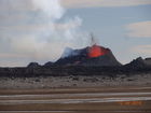
A glimpse into the field
In this news article, a report of three days in the field is presented with portraits of the key players in this show of nature‘s dangerous forces: Suðri, Baugur and Baugur‘s babies, while Norðri, active some days ago, doesn‘t deserve a mention anymore. Fate turns quickly in the field.
Given the dangerous gas levels at the eruptive site which get carried, albeit dispersed, from the highlands down into the deep firths of the Eastfjords and their farming grounds and fishing villages; the Icelandic Met Office has begun to issue warnings when necessary. They are found in a yellow ribbon in the header of every web page of en.vedur.is when relevant. When no warnings are being issued, the yellow ribbon disappears.
Read more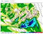
Bad weather expected on Sunday
A deep and sharp low will approach Iceland from the southwest 31st August. Southerly and southeasterly winds are expected, 25-25 m/s, and very strong gusts near mountains. Considerable rain will probably follow in all of the country, especially in the Southeast and there is a risk of mudslides in Southeast. People are advised to check on their property and fasten loose objects. This low is the remains of "Cristobal" which caused damage in the Caribbean last week-end. Travellers are advised against fording rivers in South Iceland.
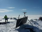
Hard work in harsh circumstances
Since the first day of the seismic activity, technical and scientific staff have worked hard under tough circumstances. Long distances have been traversed in specialised vehicles or staff have been transported by the Coast Guard‘s helicopter. They report to headquarters twice a day and their positioning is monitored continually. The equipment which is being mounted must endure harsh environment. This significant enhancement of monitoring was made possible by, Future Volc, and by the University of Cambridge.

A reconnaissance flight with TF-SIF
A flight was made to Bárðarbunga and along the glacial river, with the aircraft TF-SIF from the Icelandic Coast Guard. The onboard SAR-radar was used to image the glacier and the river.
If the present seismic activity in Bárðarbunga leads to an eruption and consequently a glacial outburst flood (jökulhlaup), these images will become an important dataset for estimating the changes which may occur on the glacier and on the flooded area.
Read more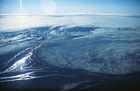
Seismic activity still great
07:04 Seismic activity in Bárðarbunga and vicinity is still great. As yesterday, the main activity stems from the intrusive event under Dyngjujökull. A few earthquakes, shallower than those described above, have occurred in Bárðarbunga, where the activity started. This is the same pattern as during previous days.
Additional web-material in English is now available through links in the header.
Updated summary from Bárðarbunga
12:56 Around 1.000 small earthquakes were detected in the Bárðarbunga region from midnight (18/19) until Tuesday evening 19th August at 20:00. All of them were smaller than magnitude 3 and most were located in the cluster east of Bárðarbunga. Events are still located at around 5-12 km depths, no signs of upwards migration has been seen so far.
Read more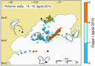
Summary of activity in Bárðarbunga
09:43 Since the onset of the earthquake swarm at Bárðarbunga on Saturday morning, around 2.600 earthquakes have been detected with the earthquake monitoring network of the Icelandic Meteorological Office (IMO). Throughout the whole sequence the majority of events has been at 5-10km depth. No signs of migration towards the surface or any other signs of imminent or ongoing volcanic activity have been detected. IMO is monitoring the area closely and will update in case of any changes.
Read more
Seismic activity at Bárðarbunga persists
11:35 The intense seismic activity that started 16 August at Bárðarbunga persists. Very strong indications of ongoing magma movement, in connection with dyke intrusion, is corroborated by GPS measurements. Presently there are no signs of eruption, but it cannot be excluded that the current activity will result in an explosive subglacial eruption, leading to an outburst flood (jökulhlaup) and ash emission. The situation is monitored closely.
Read moreSearch
Contact IMO
© Veðurstofa Íslands | Bústaðavegi 7- 9 | 105 Reykjavík | Phone 522 6000 | Fax: 522 6001
Recording 902 0600 | SSN 630908-0350
Contact us | Employees | Terms and conditions | Sitemap


